Elizaville, Kentucky facts for kids
Quick facts for kids
Elizaville, Kentucky
|
|
|---|---|

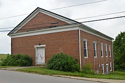
The former Elizaville Presbyterian Church
|
|
| Country | United States |
| State | Kentucky |
| County | Fleming |
| Area | |
| • Total | 1.03 sq mi (2.66 km2) |
| • Land | 1.03 sq mi (2.66 km2) |
| • Water | 0.00 sq mi (0.01 km2) |
| Elevation | 922 ft (281 m) |
| Population
(2020)
|
|
| • Total | 190 |
| • Density | 185.19/sq mi (71.49/km2) |
| Time zone | UTC-5 (Eastern (EST)) |
| • Summer (DST) | UTC-4 (EDT) |
| ZIP code |
41037
|
| Area code(s) | 606 |
| GNIS feature ID | 2629608 |
Elizaville is a small community in Fleming County, Kentucky, United States. It is known as a census-designated place, which means it's an area identified by the U.S. Census Bureau for statistical purposes. It is also an unincorporated community, meaning it does not have its own local government like a city or town.
In 2020, about 190 people lived in Elizaville. You can find Elizaville where Kentucky Route 32 and Kentucky Route 170 meet. It's about 5 miles (8 km) west of Flemingsburg. Elizaville has its own post office with the ZIP code 41037.
Contents
History of Elizaville
Elizaville has a long history. A post office was first opened here in 1819. The community was named after the daughter of one of its first important citizens.
Historic Places in Elizaville
There are a few historic spots in Elizaville that are important to its past. These include the old Elizaville Presbyterian Church and the Elizaville Cemetery. These places help tell the story of the community over the years.
Understanding Elizaville's Population
When we talk about demographics, we are looking at facts about the people who live in a place. This includes things like how many people there are.
Population Changes Over Time
According to the 2020 United States Census, Elizaville had a population of 190 people. This number helps us understand how the community has grown or changed over time.
See also
In Spanish: Elizaville (Kentucky) para niños
 | Emma Amos |
 | Edward Mitchell Bannister |
 | Larry D. Alexander |
 | Ernie Barnes |


