Emiliano Zapata Municipality, Veracruz facts for kids
Quick facts for kids
Emiliano Zapata, Veracruz
|
||
|---|---|---|
|
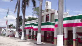
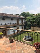
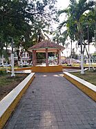
Top: Emiliano Zapata Municipal Palace; Middle: El Lencero gardens, Rinconada main plaza; Bottom: El Lencero Airport, El Lencero old buildings
|
||
|
||
| Country | ||
| State | Veracruz | |
| Region | Capital Region | |
| Municipal seat | Dos Ríos, Veracruz | |
| Largest town | Jacarandas | |
| Area | ||
| • Total | 415.7 km2 (160.5 sq mi) | |
| Elevation
(of seat)
|
827 m (2,713 ft) | |
| Population
(2020)
|
||
| • Total | 85,489 | |
| • Density | 415.7/km2 (1,077/sq mi) | |
| • Seat | 1,698 | |
| Time zone | UTC-6 (Central (US Central)) | |
| Postal code (of seat) |
55697
|
|
| Website | https://www.emilianozapata.gob.mx/ | |
| Historical population | ||
|---|---|---|
| Year | Pop. | ±% |
| 1995 | 40,411 | — |
| 2000 | 44,580 | +10.3% |
| 2005 | 49,476 | +11.0% |
| 2010 | 61,718 | +24.7% |
| 2015 | 78,336 | +26.9% |
| 2020 | 85,489 | +9.1% |
Emiliano Zapata is a special area in the Mexican state of Veracruz. It is called a municipality. This area is named after Emiliano Zapata, a famous hero from the Mexican Revolution.
The main town where the local government is located is called Dos Ríos. Emiliano Zapata is about 2 kilometers from Jalapa-Enríquez. You can reach it by using Federal Highways 180 and 190.
Contents
Where is Emiliano Zapata?
Neighboring Areas
Emiliano Zapata shares its borders with several other municipalities. These are like its neighbors.
- To the northwest, it borders Xalapa.
- To the northeast, you'll find Actopan.
- To the south, it's next to Puente Nacional and Apazapan.
- Also to the south, it borders Jalcomulco.
- To the west, it's next to Coatepec.
People Living in Emiliano Zapata
Population Facts
In 2020, about 85,489 people lived in the Emiliano Zapata municipality. These people live in 141 different towns and villages.
Only a small part of the population, about 1,698 people, lives in Dos Ríos. Remember, Dos Ríos is the main government town.
Biggest Towns
Most people in Emiliano Zapata live in larger towns. Here are some of the biggest ones:
- Jacarandas has about 11,864 people.
- Rinconada is home to about 8,005 people.
- La Pradera has around 7,500 residents.
- La Estanzuela has about 4,951 people.
- El Carrizal is home to about 4,714 people.
Roads and Travel
Main Roads in the Area
Two important roads help people travel through Emiliano Zapata. These are:
See Also
 In Spanish: Municipio de Emiliano Zapata (Veracruz) para niños
 | Emma Amos |
 | Edward Mitchell Bannister |
 | Larry D. Alexander |
 | Ernie Barnes |


