
Enchastrayes facts for kids
Quick facts for kids
Enchastrayes
|
|
|---|---|

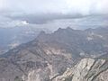
The summit of the Chapeau de Gendarme (Gendarme Hat) south-west of Enchastrayes
|
|

Enchastrayes
Location in France

Enchastrayes
Location in Provence-Alpes-Côte d'Azur
|
|
| Country | France |
| Region | Provence-Alpes-Côte d'Azur |
| Department | Alpes-de-Haute-Provence |
| Arrondissement | Barcelonnette |
| Canton | Barcelonnette |
| Intercommunality | Vallée de l'Ubaye |
| Area
1
|
44.19 km2 (17.06 sq mi) |
| Population
(Jan. 2019)
|
388 |
| • Density | 8.780/km2 (22.74/sq mi) |
| Time zone | UTC+01:00 (CET) |
| • Summer (DST) | UTC+02:00 (CEST) |
| INSEE/Postal code |
04073 /04400
|
| Elevation | 1,151–2,775 m (3,776–9,104 ft) (avg. 1,450 m or 4,760 ft) |
| 1 French Land Register data, which excludes lakes, ponds, glaciers > 1 km2 (0.386 sq mi or 247 acres) and river estuaries. | |
Enchastrayes is a small and charming commune located in the Alpes-de-Haute-Provence department. This area is in the beautiful southeastern part of France. A commune is like a small town or village with its own local government.
Discover Enchastrayes
Enchastrayes is known for its stunning natural beauty. It is nestled among mountains, making it a great place for outdoor adventures. The famous Enciastraia mountain is actually located within this commune.
Location and Landscape
Enchastrayes is found in the Alpes-de-Haute-Provence department. This region is part of the larger Provence-Alpes-Côte d'Azur area in southeastern France. The commune is part of the Barcelonnette arrondissement and canton.
The landscape around Enchastrayes is very mountainous. The elevation of the commune ranges quite a bit. The lowest point is about 1,151 meters (around 3,776 feet) above sea level. The highest point reaches an impressive 2,775 meters (about 9,104 feet). The main village sits at an elevation of 1,450 meters (around 4,757 feet).
People and Community
As of January 2019, Enchastrayes was home to about 388 people. This makes it a small and close-knit community. The total area of the commune is 44.19 square kilometers (about 17.06 square miles).
The people of Enchastrayes are part of the larger "Vallée de l'Ubaye" intercommunality. This means they work together with nearby communes on shared projects and services.
Images for kids
-
The summit of the Chapeau de Gendarme (Gendarme Hat) south-west of Enchastrayes
See also
 In Spanish: Enchastrayes para niños
