Englehart River facts for kids
Quick facts for kids Englehart River |
|
|---|---|

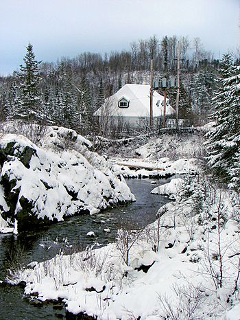
Englehart River at Charlton in winter
|
|
|
Location of the mouth of the Englehart River in Ontario
|
|
| Country | Canada |
| Province | Ontario |
| Region | Northeastern Ontario |
| District | Timiskaming |
| Physical characteristics | |
| Main source | Fallduck Lakes Terry Township 324 m (1,063 ft) 48°11′39″N 80°27′03″W / 48.19417°N 80.45083°W |
| River mouth | Blanche River Marter Township 180 m (590 ft) 47°50′48″N 79°50′22″W / 47.84667°N 79.83944°W |
| Length | 105 km (65 mi) |
| Basin features | |
| River system | Saint Lawrence River drainage basin |
| Basin size | 1,110 km2 (430 sq mi) |
The Englehart River is a cool river in northeastern Ontario, Canada. It flows through the Timiskaming District. This river is part of the huge Saint Lawrence River system. It eventually joins the Blanche River.
Contents
The River's Journey
The Englehart River starts its journey at Fallduck Lakes. These lakes are located in Terry Township. From there, the river flows towards the southeast.
It goes under Ontario Highway 66 and then reaches Long Lake. After Long Lake, the river turns east. It flows over a dam and under Ontario Highway 573. This happens near the community of Charlton.
The river continues its path under Ontario Highway 560. Along its way, it passes several exciting waterfalls and rapids. These include Sunday Creek Falls, Horseshoe Falls, Hell's Gate, High Falls, and Nuisance Rapids.
After these exciting spots, the river turns north. It flows under Ontario Highway 11 and the Ontario Northland Railway mainline. This is near the town of Englehart. Finally, the Englehart River reaches its end. It flows into the Blanche River in Marter Township. The Blanche River then flows into the Ottawa River, which eventually joins the Saint Lawrence River.
River Size and Area
The Englehart River is about 105 kilometers (65 miles) long. The area of land that drains into the river is called its watershed. The Englehart River's watershed is quite large. It covers about 1,110 square kilometers (429 square miles).
Parks Along the River
You can find two cool provincial parks along the Englehart River.
Kap-Kig-Iwan Provincial Park
Kap-Kig-Iwan Provincial Park is located right on the river. It's found between the communities of Charlton and Englehart. This park is a great place to explore nature.
Englehart River Fine Sand Plain and Waterway Provincial Park
Another park is the Englehart River Fine Sand Plain and Waterway Provincial Park. This park includes parts of the river. One section is between Ontario Highway 66 and the northwestern part of Long Lake. Other parts are found on the southeastern side of Long Lake.
River Branches
Many smaller streams and creeks flow into the Englehart River. These are called tributaries. They add water to the main river as it flows.
- Crocodile Creek (from the left side)
- St. Jean Baptiste Creek (from the right side)
- Sunday Creek (from the right side)
- Long Lake has its own tributaries:
- Tamarac Creek (from the right side)
- Aidie Creek (from the left side)
- Driftwood Creek (from the right side)
- Teepee Creek (from the right side)
- Flavelle Creek (from the right side)
- Middleton Creek (from the right side)
- Burt Creek (from the left side)
- Kenaja Creek (from the right side)
- Rib Creek (from the left side)
 | Frances Mary Albrier |
 | Whitney Young |
 | Muhammad Ali |


