Erin, Tennessee facts for kids
Quick facts for kids
Erin, Tennessee
|
|
|---|---|

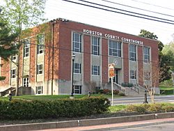
Houston County Courthouse
|
|
| Nickname(s):
Irish Town Tennessee, The Shamrock City
|
|

Location of Erin in Houston County, Tennessee.
|
|
| Country | United States |
| State | Tennessee |
| County | Houston |
| Settled | approx. 1780 |
| Area | |
| • Total | 3.90 sq mi (10.10 km2) |
| • Land | 3.90 sq mi (10.09 km2) |
| • Water | 0.00 sq mi (0.01 km2) |
| Elevation | 480 ft (146 m) |
| Population
(2020)
|
|
| • Total | 1,224 |
| • Density | 314.17/sq mi (121.29/km2) |
| Time zone | UTC-6 (CST) |
| • Summer (DST) | UTC-5 (CDT) |
| ZIP code |
37061
|
| Area code(s) | 931 |
| FIPS code | 47-24320 |
| GNIS feature ID | 1283839 |
Erin is a small city in Houston County, Tennessee. It is the main town, also known as the county seat. In 2020, about 1,224 people lived there. In 2010, the population was 1,324.
Contents
History of Erin
The city of Erin might have been named after Erin, which is a poetic way to refer to Ireland.
Every year in March, the town hosts a special Irish festival. This tradition started in 1962. It's a week-long event and is considered one of the top ten Irish celebrations in the U.S. The festival includes a parade, banquets, pageants, and displays of arts and crafts. It celebrates Erin's Irish heritage and honors the hard work of Irish railroad workers who helped connect the town to the rest of the world.
Geography of Erin
Erin is located at 36°19′1″N 87°41′53″W / 36.31694°N 87.69806°W. It sits about 480 feet (146 meters) above sea level.
The United States Census Bureau says that Erin covers a total area of about 4.1 square miles (10.1 square kilometers). All of this area is land.
Main Roads in Erin
- State Route 13
- State Route 49 (also known as Main Street)
- State Route 149
ZIP Code and Area Code
The ZIP code for the Erin area is 37061. Erin uses the area code 931 for phone numbers.
People in Erin (Demographics)
| Historical population | |||
|---|---|---|---|
| Census | Pop. | %± | |
| 1880 | 485 | — | |
| 1890 | 789 | 62.7% | |
| 1910 | 943 | — | |
| 1920 | 855 | −9.3% | |
| 1930 | 819 | −4.2% | |
| 1940 | 905 | 10.5% | |
| 1950 | 858 | −5.2% | |
| 1960 | 1,097 | 27.9% | |
| 1970 | 1,165 | 6.2% | |
| 1980 | 1,614 | 38.5% | |
| 1990 | 1,586 | −1.7% | |
| 2000 | 1,490 | −6.1% | |
| 2010 | 1,324 | −11.1% | |
| 2020 | 1,224 | −7.6% | |
| Sources: | |||
Erin's Population in 2020
| Race | Number | Percentage |
|---|---|---|
| White (non-Hispanic) | 1,054 | 86.11% |
| Black or African American (non-Hispanic) | 84 | 6.86% |
| Native American | 3 | 0.25% |
| Asian | 3 | 0.25% |
| Pacific Islander | 5 | 0.41% |
| Other/Mixed | 44 | 3.59% |
| Hispanic or Latino | 31 | 2.53% |
According to the 2020 United States census, there were 1,224 people living in Erin. These people lived in 514 households, and 251 of these were families.
Schools in Erin
Erin has several public schools for students of different ages.
High Schools
- Houston County Adult High School: This school is for students in grades 11 and 12. It is located at 3573 West Main Street.
- Houston County High School: This school serves students from grade 9 to 12. It is located on Highway 149 Street.
Primary and Middle Schools
- Erin Elementary School: This school teaches students from Kindergarten to 5th grade. About 456 students attend here. It is located at 6500 State Route 13.
- Houston County Middle School: This school is for students in grades 6 to 8. Around 338 students go to this school. It is located at 1241 West Main Street.
See also
 In Spanish: Erin (Tennessee) para niños
 | Audre Lorde |
 | John Berry Meachum |
 | Ferdinand Lee Barnett |

