Bioko facts for kids
|
Native name:
Ëtulá Ëria
|
|
|---|---|

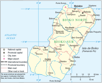
Map of Bioko
|
|
| Geography | |
| Location | Gulf of Guinea |
| Coordinates | 3°30′N 8°42′E / 3.500°N 8.700°E |
| Area | 2,017 km2 (779 sq mi) |
| Length | 70 km (43 mi) |
| Width | 32 km (19.9 mi) |
| Highest elevation | 3,012 m (9,882 ft) |
| Highest point | Pico Basile |
| Administration | |
|
Equatorial Guinea
|
|
| Largest settlement | Malabo (pop. 155,963 (2005 estimate)) |
| Demographics | |
| Population | 334,463 (2015 Census (preliminary)) |
| Pop. density | 165.8 /km2 (429.4 /sq mi) |
| Ethnic groups | Bubi (58%), Fang (16%), Fernandino (12%), Igbo (7%) (2002) |
Bioko is an island about 32 kilometers (20 miles) off the west coast of Africa. It is the northernmost part of Equatorial Guinea. The island sits in the Bight of Bonny, which is a part of the larger Gulf of Guinea.
Bioko covers a total area of 2,017 square kilometers (779 square miles). It is about 70 kilometers (43 miles) long and 32 kilometers (20 miles) wide. The highest point on the island is Pico Basile, a volcano that reaches 3,012 meters (9,882 feet) high.
Contents
Where is Bioko Island Located?
Bioko is an island in the Gulf of Guinea, close to the coast of West Africa. It is the largest island belonging to Equatorial Guinea. The capital city of Equatorial Guinea, Malabo, is located on Bioko.
Geography and Landscape
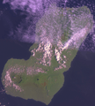
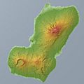
The island was formed by volcanoes, which is why it has tall peaks. Pico Basile is the highest of these. The island's volcanic past also means it has fertile soil. This soil is good for growing crops.
Bioko has a tropical climate. This means it is warm and humid all year round. There are also two main seasons: a wet season and a dry season. The island gets a lot of rain, especially in the wet season.
The coastline of Bioko has sandy beaches and rocky areas. There are also many small rivers and streams. These flow down from the mountains to the sea.
Who Lives on Bioko?
The main group of people living on Bioko are the Bubi people. They are the original inhabitants of the island. Other groups include the Fang people, Fernandino people, and Igbo people.
Languages and Culture
The official language of Equatorial Guinea is Spanish. However, many people on Bioko also speak local languages. The Bubi people speak the Bubi language.
The culture on Bioko is a mix of African traditions and Spanish influences. This comes from the island's history as a Spanish colony. Music, dance, and storytelling are important parts of daily life.
A Look at Bioko's History
Bioko has a long and interesting history. It was first explored by Europeans in the late 1400s.
Early European Contact
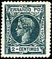
In 1472, a Portuguese explorer named Fernão do Pó was the first European to see the island. He named it "Formosa," meaning "beautiful." Later, the island was named after him, becoming "Fernando Pó."
Portugal claimed the island for many years. They used it as a trading post. In 1778, Portugal traded Fernando Pó and some other territories to Spain. This was part of a deal called the Treaty of El Pardo.
Spanish Rule and Independence
Spain then ruled Bioko for a long time. They used the island for plantations, growing crops like cocoa. Many people were brought to the island to work on these farms.
In 1968, Equatorial Guinea gained its independence from Spain. Fernando Pó became part of the new country. The island was later renamed Bioko. This new name honors the Bubi people.
Wildlife and Nature
Bioko is home to many different kinds of animals and plants. The island has thick rainforests. These forests are important habitats for wildlife.
Animals of Bioko
You can find various monkeys on Bioko. Some of these are found nowhere else in the world. There are also many types of birds, reptiles, and insects. The island's unique wildlife makes it a special place for nature lovers.
Protecting the Environment
Efforts are being made to protect Bioko's natural environment. This includes its rainforests and the animals that live there. Conservation groups work to keep the island's ecosystems healthy.
Images for kids
-
1908 map of Fernando Po and the coast of Cameroons
See also
 In Spanish: Bioko para niños
 | Jessica Watkins |
 | Robert Henry Lawrence Jr. |
 | Mae Jemison |
 | Sian Proctor |
 | Guion Bluford |


