Ferndale, Maryland facts for kids
Quick facts for kids
Ferndale, Maryland
|
|
|---|---|

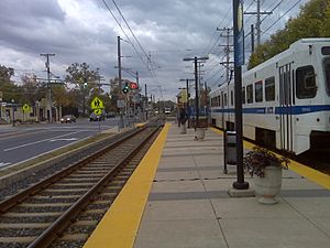
Ferndale Station platform.
|
|

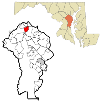
Location of Ferndale, Maryland
|
|
| Country | |
| State | |
| County | |
| Area | |
| • Total | 3.96 sq mi (10.25 km2) |
| • Land | 3.96 sq mi (10.25 km2) |
| • Water | 0.00 sq mi (0.00 km2) |
| Elevation | 79 ft (24 m) |
| Population
(2020)
|
|
| • Total | 17,091 |
| • Density | 4,319.18/sq mi (1,667.83/km2) |
| Time zone | UTC-5 (Eastern (EST)) |
| • Summer (DST) | UTC-4 (EDT) |
| FIPS code | 24-28075 |
| GNIS feature ID | 0590203 |
Ferndale is a community in Anne Arundel County, Maryland, in the United States. It's not a city or town with its own government. Instead, it's a special area defined for counting people, called a census-designated place (CDP). In 2010, about 16,746 people lived there. By 2020, the population grew to 17,091.
Contents
Discover Ferndale's Location
Ferndale is located in northern Anne Arundel County. It is about 5 miles (8 kilometers) south of the Baltimore city line. You can find its exact spot using these coordinates: 39°11′17″N 76°38′9″W / 39.18806°N 76.63583°W.
What Borders Ferndale?
Ferndale is surrounded by several important roads and natural features. To the north, you'll find Interstate 695, also known as the Baltimore Beltway, and a stream called Cabin Branch. To the west, Maryland Route 162 (Aviation Boulevard) forms a border. South of Ferndale are Maryland Route 176 (Dorsey Road) and 8th Avenue. To the east, Maryland Route 2 (Governor Ritchie Highway) marks the edge.
Nearby Communities and Airport
Ferndale has several neighbors. To the northwest is Linthicum. Brooklyn Park is to the northeast. Both Glen Burnie and Baltimore–Washington International Thurgood Marshall Airport are close by. The airport is just west of Ferndale, across Aviation Boulevard.
How Big is Ferndale?
The total area of Ferndale is about 3.96 square miles (10.3 square kilometers). All of this area is land, meaning there are no large bodies of water like lakes or rivers within its boundaries.
Ferndale's Climate Explained
The weather in Ferndale is known for its hot and humid summers. Winters are usually mild to cool. This type of weather is called a humid subtropical climate. On climate maps, it's often shown as "Cfa."
Understanding Ferndale's Population
| Historical population | |||
|---|---|---|---|
| Census | Pop. | %± | |
| 2020 | 17,091 | — | |
| U.S. Decennial Census | |||
In 2000, there were 16,056 people living in Ferndale. These people lived in 6,240 households, and 4,286 of these were families. The population density was about 3,952 people per square mile (1,526 people per square kilometer). There were also 6,443 housing units available.
Who Lives in Ferndale?
The people living in Ferndale come from many different backgrounds. In 2000, most residents were White (77.20%). About 15.60% were African American, and 3.29% were Asian. A smaller number were Native American (0.40%) or Pacific Islander (0.02%). About 1.47% were from other races, and 2.02% identified with two or more races. People of Hispanic or Latino background made up 3.11% of the population.
Households and Families
In Ferndale, about 32.7% of households had children under 18 living with them. Many households (48.3%) were married couples living together. About 15.1% of households were led by a female without a husband present. Roughly 24.1% of all households were made up of individuals living alone. About 9.1% of households had someone aged 65 or older living by themselves. The average household had 2.57 people, and the average family had 3.05 people.
Age Groups in Ferndale
The population of Ferndale includes people of all ages. In 2000, about 25.5% of the people were under 18 years old. About 8.2% were between 18 and 24. The largest group, 33.5%, was between 25 and 44 years old. People aged 45 to 64 made up 20.5% of the population. Finally, 12.4% of the residents were 65 years or older. The average age in Ferndale was 35 years.
Income in Ferndale
In 2000, the average income for a household in Ferndale was $45,816. For families, the average income was $51,289. Men had an average income of $38,068, while women had an average income of $28,892. The income per person in Ferndale was $20,806.
See also
 In Spanish: Ferndale (Maryland) para niños
 | Bessie Coleman |
 | Spann Watson |
 | Jill E. Brown |
 | Sherman W. White |

