Flintville, Tennessee facts for kids
Quick facts for kids
Flintville, Tennessee
|
|
|---|---|

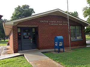
Flintville Post office (2013)
|
|

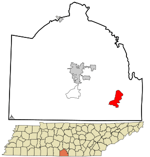
Location within Lincoln County and Tennessee
|
|
| Country | United States |
| State | Tennessee |
| County | Lincoln |
| Area | |
| • Total | 5.32 sq mi (13.79 km2) |
| • Land | 5.32 sq mi (13.79 km2) |
| • Water | 0.00 sq mi (0.00 km2) |
| Elevation | 902 ft (275 m) |
| Population
(2020)
|
|
| • Total | 722 |
| • Density | 135.64/sq mi (52.37/km2) |
| Time zone | UTC-6 (CST) |
| • Summer (DST) | UTC-5 (CDT) |
| ZIP code |
37335
|
| Area code | 931 |
| FIPS code | 47-26580 |
| GNIS ID | 1284492 |
Flintville is a small community in Lincoln County, Tennessee, United States. It is called an "unincorporated community" because it doesn't have its own separate city government. Instead, it's part of the larger county.
In 2010, about 627 people lived in Flintville. By 2020, the population grew to 722 people. Flintville is located about 10.5 miles (17 kilometers) southeast of Fayetteville. You can find it along Tennessee State Route 275 highway.
Who Lives in Flintville?
| Historical population | |||
|---|---|---|---|
| Census | Pop. | %± | |
| 2020 | 722 | — | |
| U.S. Decennial Census | |||
When we talk about "demographics," we are looking at facts about the people who live in a place. This includes how many people there are and how the population changes over time.
The United States Census Bureau helps us understand these numbers. They have marked Flintville as a "census-designated place" (CDP). This means it's an area that the Census Bureau defines for collecting population data, even though it's not an official city or town. It helps them count everyone accurately.
See also
 In Spanish: Flintville (Tennessee) para niños
 | Laphonza Butler |
 | Daisy Bates |
 | Elizabeth Piper Ensley |

