Forest-Saint-Julien facts for kids
Quick facts for kids
Forest-Saint-Julien
|
||
|---|---|---|

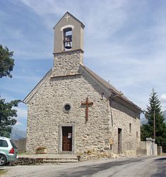
The chapel of Forest-Saint-Julien
|
||
|
||
| Country | France | |
| Region | Provence-Alpes-Côte d'Azur | |
| Department | Hautes-Alpes | |
| Arrondissement | Gap | |
| Canton | Saint-Bonnet-en-Champsaur | |
| Intercommunality | Champsaur-Valgaudemar | |
| Area
1
|
6.95 km2 (2.68 sq mi) | |
| Population
(Jan. 2019)
|
334 | |
| • Density | 48.06/km2 (124.47/sq mi) | |
| Time zone | UTC+01:00 (CET) | |
| • Summer (DST) | UTC+02:00 (CEST) | |
| INSEE/Postal code |
05056 /05260
|
|
| Elevation | 1,015–1,631 m (3,330–5,351 ft) (avg. 1,200 m or 3,900 ft) |
|
| 1 French Land Register data, which excludes lakes, ponds, glaciers > 1 km2 (0.386 sq mi or 247 acres) and river estuaries. | ||
Forest-Saint-Julien is a small village, also known as a commune, located in the Hautes-Alpes department of France. A commune is like a local government area, similar to a town or parish. A department is a larger region, like a county.
Contents
About Forest-Saint-Julien
Forest-Saint-Julien is found in the beautiful French Alps. It is known for its peaceful setting and natural beauty. The village is part of the Champsaur-Valgaudemar area.
Population Facts
As of January 2019, about 334 people lived in Forest-Saint-Julien. This makes it a very small and quiet community. The number of people living here has stayed fairly steady over the past few years.
Local Government
The mayor of Forest-Saint-Julien is Fabrice Borel. He helps lead the community from 2020 to 2026. The village is part of the Saint-Bonnet-en-Champsaur canton and the Gap arrondissement. These are different ways France organizes its local areas.
Getting Around
Forest-Saint-Julien is connected by several roads. These roads help people travel to and from the village.
Main Roads
The D13, D14, D114, D215, D414, and D944 roads all pass through the commune. These roads are important for local transport.
See also
 In Spanish: Forest-Saint-Julien para niños
 | Sharif Bey |
 | Hale Woodruff |
 | Richmond Barthé |
 | Purvis Young |


