Forestbrook, South Carolina facts for kids
Quick facts for kids
Forestbrook, South Carolina
|
|
|---|---|

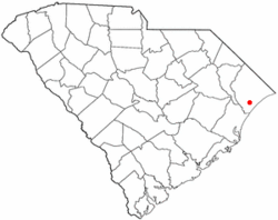
Location in South Carolina
|
|
| Country | United States |
| State | South Carolina |
| County | Horry |
| Area | |
| • Total | 3.67 sq mi (9.51 km2) |
| • Land | 3.67 sq mi (9.51 km2) |
| • Water | 0.00 sq mi (0.00 km2) |
| Elevation | 16 ft (5 m) |
| Population
(2020)
|
|
| • Total | 6,656 |
| • Density | 1,813.62/sq mi (700.23/km2) |
| Time zone | UTC-5 (EST) |
| • Summer (DST) | UTC-4 (EDT) |
| ZIP Code |
29579
|
| FIPS code | 45-26372 |
| GNIS feature ID | 1243725 |
Forestbrook is a special kind of community in Horry County, South Carolina, United States. It's called a census-designated place (CDP). This means it's an area that looks like a town but isn't officially a city or village.
In 2010, about 4,612 people lived here. By 2020, the population grew to 6,656 people. This shows that more and more families are choosing to call Forestbrook home!
Contents
Where is Forestbrook Located?
Forestbrook is in the southern part of Horry County. You can find it about 5 miles (8 kilometers) northwest of the popular beach city, Myrtle Beach. It's also about 10 miles (16 kilometers) southeast of Conway, which is the main town for Horry County.
Nearby Roads and Natural Features
The community has some important roads nearby. U.S. Route 501 runs along its northeast side. The South Carolina Highway 31, also known as the Carolina Bays Parkway, forms its northwest border. To the southeast, Forestbrook is bordered by the Socastee Swamp, a natural wetland area.
According to the United States Census Bureau, Forestbrook covers an area of about 3.7 square miles (9.7 square kilometers). All of this area is land.
Who Lives in Forestbrook?
The number of people living in Forestbrook has been growing.
| Historical population | |||
|---|---|---|---|
| Census | Pop. | %± | |
| 2020 | 6,656 | — | |
| U.S. Decennial Census | |||
Forestbrook's Population in 2020
In 2020, there were 6,656 people living in Forestbrook. These people lived in 2,528 different homes, and 1,936 of these were family households.
Here's a quick look at the different groups of people living in Forestbrook in 2020:
| Group | Number of People | Percentage |
|---|---|---|
| White (not Hispanic) | 5,386 | 80.92% |
| Black or African American (not Hispanic) | 400 | 6.01% |
| Native American | 21 | 0.32% |
| Asian | 72 | 1.08% |
| Pacific Islander | 8 | 0.12% |
| Other/Mixed | 357 | 5.36% |
| Hispanic or Latino | 412 | 6.19% |
See also

- In Spanish: Forestbrook para niños
 | Chris Smalls |
 | Fred Hampton |
 | Ralph Abernathy |

