Forrest, Arizona facts for kids
Quick facts for kids
Forrest, Arizona
|
|
|---|---|
|
Populated place
|
|

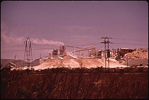
Paul Lime Plant in 1972
|
|
| Country | United States |
| State | Arizona |
| County | Cochise |
| Elevation | 4,196 ft (1,279 m) |
| Time zone | UTC-7 (Mountain (MST)) |
| • Summer (DST) | UTC-7 (MST) |
| Area code(s) | 520 |
| FIPS code | 04-24180 |
| GNIS feature ID | 24420 |
Forrest was a place in Cochise County, Arizona, United States. It was once a populated area, but it is no longer a town today.
History of Forrest
Forrest was located along an important railway line. This line was called the El Paso and Southwestern Railroad. The place was named after an old local resident and rancher.
The Paul Lime Plant
A large factory called the Paul Lime Plant started working nearby in 1918. This plant made lime, which is a material used in many products. The railway line that went to the plant was renamed Paul's Spur. By the 1940s, the Paul Lime Plant was the biggest producer of lime in Southern Arizona.
Life in Forrest
Forrest had its own post office. It opened on May 8, 1914. There was also a school called Forrest School. The school building was destroyed by fire two times! The first fire happened in 1915. The second fire was in 1929. After the second fire, a bigger, stronger brick building was built for the school.
At one time, about 200 families lived near Forrest. They worked at the lime plant. But new machines made the work easier. This meant the plant needed fewer workers. So, the number of people living in Forrest dropped. The school closed in 1963. Even after the school closed, the Forrest School District still existed. It helped transport students to schools in Douglas.


