
Fort Ricasoli facts for kids
Quick facts for kids Fort Ricasoli |
|
|---|---|
| Forti Rikażli | |
| Kalkara, Malta | |

View of Fort Ricasoli from Valletta
|
|

Map of Fort Ricasoli
|
|
| Coordinates | 35°53′51″N 14°31′33″E / 35.89750°N 14.52583°E |
| Type | Bastioned fort |
| Area | 83,800 m2 (902,000 sq ft) |
| Height | up to 20 m (66 ft) |
| Site information | |
| Owner | Government of Malta |
| Controlled by | Malta Film Commission Waste Oils Co. Ltd. |
| Open to the public |
No |
| Condition | Mostly intact but dilapidated |
| Site history | |
| Built | 1670–1698 |
| Built by | Order of Saint John |
| In use | 1674–1964 |
| Materials | Limestone |
| Battles/wars | French invasion of Malta (1798) Siege of Malta (1798–1800) World War II |
| Events | Froberg mutiny |
Fort Ricasoli (in Maltese: Forti Rikażli) is a large fort in Kalkara, Malta. It was built by the Order of Saint John between 1670 and 1698. The fort sits on a piece of land called Gallows' Point. It guards the entrance to the Grand Harbour along with Fort Saint Elmo.
Fort Ricasoli is the biggest fort in Malta and one of the largest in Europe. Since 1998, it has been considered for a spot on the UNESCO World Heritage Site list. It is part of the "Knights' Fortifications around the Harbours of Malta."
The fort was used during the French invasion of Malta in 1798. It also played a role in the Maltese uprising that followed. Later, it came under British control. In 1807, the Froberg mutiny happened here. The fort also served as a military hospital in the 1800s.
During World War II, parts of Fort Ricasoli were damaged by bombs from the air. After it stopped being a military site in the 1960s, it was used for industrial purposes. Today, the fort is still mostly standing but needs repairs. It is used as a place for filming movies and for cleaning large tanks. Plans to fix up the fort were approved in June 2019.
Contents
Building Fort Ricasoli: A Look at its History
Why was Fort Ricasoli Built?
Fort Ricasoli is located on the easternmost point of land on the east side of the Grand Harbour. This area was first known as Rinella Point. In 1531, it became known as Gallows' Point. This was after two leaders of a slave rebellion were hanged there. They had tried to take over Fort St. Angelo and escape from Malta.
During the Great Siege of Malta in 1565, the Ottoman forces built a cannon battery on this point. They used it to fire at Fort St. Elmo.

In 1602, a small battery called San Petronio Battery was built at Gallows' Point. It was later known as Orsi Battery. In 1629, a knight named Alessandro Orsi paid for a tower near the battery. It was called Torre San Petronio, but people often called it Orsi Tower. The tower was built to stop slaves from escaping the island.
The tower and battery were protected by a water-filled ditch and a drawbridge. They can be seen in a 1664 drawing of the Grand Harbour. The tower and battery were destroyed by a storm in 1821. Today, only the rock-cut ditch of the battery remains.
In 1644, Giovanni de’ Medici suggested building a new fort on Orsi Point. He even drew plans for it. However, these plans were never put into action.
How Fort Ricasoli was Built and Changed Over Time

In 1669, people worried about an attack from the Ottoman Empire. The next year, Grand Master Nicolas Cotoner asked Antonio Maurizio Valperga, a military engineer, to improve Malta's defenses. Valperga designed a new fort for the headland.
A knight from Florence, Fra Giovanni Francesco Ricasoli, gave money to build the fort. It was named in his honor. Construction began on June 15, 1670. The fort received a small group of soldiers in 1674, even though it was not yet finished.
In 1681, another engineer, Carlos de Grunenbergh, suggested changes to the fort's design. These ideas were used. The living quarters, chapel, and other buildings inside the fort were built in the 1680s and 1690s. The fort was officially finished and armed in May 1698.
In 1714, French engineers thought the fort's bastions (parts that stick out) were too small. They suggested repairs and building a new inner defense. Another idea was to dig a canal to separate the fort from the mainland. In 1722, some repairs were done, but the other ideas were not carried out due to lack of money. By the mid-1700s, the fort was in poor condition, and some maintenance was done in 1761.
In 1785, Fort Ricasoli had eighty cannons, making it the most heavily armed fort in Malta. Parts of the fort's outer walls were rebuilt in the 1790s. The fort was also used as a prison before the Corradino Correctional Facility was built.
Fort Ricasoli Under French and British Rule
French Occupation and Maltese Uprising
Fort Ricasoli was used during the French invasion of Malta in June 1798. At that time, it was defended by volunteer soldiers. The fort fought off three French attacks. However, it surrendered after Grand Master Hompesch gave up to Napoleon.
During the Maltese uprising that followed, the fort stayed in French hands. It constantly fired at the Maltese rebels' San Rocco Battery.
British Control and Changes
.jpg)
Fort Ricasoli remained an active military site during the British period. In 1807, it was the scene of a mutiny. Albanian soldiers revolted and barricaded themselves inside the fort. They eventually blew up the main gunpowder storage, causing a lot of damage. The mutiny was stopped, and the damaged parts of the fort were repaired. A new gunpowder storage was built in 1829.
The fort also served as a temporary naval hospital in the late 1820s and early 1830s. This was before Bighi Hospital opened. During the cholera outbreaks in 1837 and 1865, sick patients were moved to Ricasoli. Many of them died and were buried in a nearby cemetery.

In 1844, about 500 soldiers were stationed at the fort. In 1848, Sir John Fox Burgoyne inspected Malta's forts and called Ricasoli "unbeatable." In the 1850s, more powerful cannons were added. Over the next decades, the guns were replaced many times. By 1878, the seaward outer wall was completely redone. By the 1900s, new gun positions, searchlights, and a torpedo station were installed. In the 1930s, concrete towers for controlling gunfire were built.
Fort Ricasoli helped defend Malta during World War II. On July 26, 1941, its guns helped stop an Italian attack on the Grand Harbour. In April 1942, the fort's main gate and the Governor's House were destroyed by German air raids.
After the war, the fort was used as a naval barracks from 1947 to 1958. In 1958, the gate was rebuilt, but the Governor's House was not. In 1964, the British Navy gave control of the fort to the government of Malta.
Fort Ricasoli: Recent History and Current State
Industrial Use and Filming Location

After the fort was given to the Maltese government, it was first left empty. Later, it became a storage area for materials arriving in Malta. In 1976, part of the ditch was filled in, and a section of the fort was broken through for a new road.
In 1964, the fort's ditch became a place for cleaning tanks from ships. This facility cleans liquid waste from ships in the Grand Harbour. It removes oil and chemicals before releasing the water into the sea. The facility became private in 2012 and is now managed by Waste Oils Co. Ltd.
The area around the fort became an industrial park called Ricasoli Industrial Estate. This industrial estate was torn down in 2007 to make way for SmartCity Malta.
Most of the fort is rented out to the Malta Film Commission. It has been used a lot for filming movies and TV shows. Large sets were built inside its walls for films like Gladiator (2000), Troy (2004), and Agora (2009). In these movies, the fort stood in for places like Rome, Troy, and Alexandria. The fort was also used for Assassin's Creed (2016) and Entebbe (2018).
TV shows like Julius Caesar (2002) and Helen of Troy (2003) were also partly filmed at Fort Ricasoli. A set called the Roman Road was built for Julius Caesar and has been kept for other films. The first season of HBO's Game of Thrones also used parts of the fort to represent the Red Keep.
Current Condition and Future Plans
_02_ies.jpg)

Today, Fort Ricasoli is mostly intact, but it is in poor condition. The land it is built on is affected by coastal erosion. Some of the walls have already fallen into the sea. In 2004, a part of the fort's walls was repaired. However, a full restoration of the entire fort has not yet happened.
In May 2015, some groups suggested that a new university campus should be split between Fort Ricasoli and nearby forts. This idea was not used. By 2018, groups that protect heritage had repeatedly asked for the fort to be restored. Some work to attract more film productions began in early 2019. Plans for major restoration work were approved in June 2019. This news was welcomed by many.
Fort Ricasoli: How it's Built
Fort Ricasoli has an unusual shape that follows the coastline of the land it sits on. The fort has a strong land front with outer defenses. It also has walls facing the sea and a special shape facing Rinella Bay of the Grand Harbour.
The Land Front Defenses

The land front is made up of these bastions and demi-bastions (half-bastions), connected by walls:
- St. Dominic's Demi-Bastion (also called Left Demi-Bastion or No. 5 Bastion) – This is at the northern end of the land front. It was damaged in the 1807 mutiny when its gunpowder storage blew up.
- St. Francis Bastion (also called Central Bastion or No. 6 Bastion) – This is a five-sided bastion in the middle of the land front.
- St. John's Demi-Bastion (also called Right Demi-Bastion or No. 7 Bastion) – This is at the southern end of the land front.
The land front also has casemates, which were used as barracks (places for soldiers to live).

The land front is further protected by these outer defenses:
- A low wall (called a faussebraye) that goes around the entire land front.
- St. Dominic Counterguard – A fortified outer wall near the left side of the land front. Half of it has fallen due to seawater.
- Two triangular ravelins (outer works) between St. Francis Bastion and the demi-bastions. One of them holds a large gun.
- Two covered passages (called caponiers) that lead from the land front to each ravelin. The British made many changes to these.
These outer defenses are surrounded by a ditch, a hidden path (covertway), and a gentle slope (glacis).
The Sea-Facing Walls

The walls facing the open sea include these bastions and connecting walls:
- No. 1 Bastion – This is a half-bastion that forms Point Battery. It once had a small tower, but this was removed for a torpedo system. It also has a large gun position.
- No. 1 Curtain – This wall is between No. 1 and No. 2 bastions. It has a fortified battery and a searchlight position.
- No. 2 Bastion – This bastion has openings for guns and various British gun positions, storage areas for ammunition, and a fire control tower.
- No. 2 Curtain – This wall is between No. 2 and No. 3 bastions. It has gun openings, an ammunition storage, and a searchlight position.
- No. 3 Bastion – This flat-faced bastion has gun openings and various British gun positions, ammunition storage, and a fire control tower.
- A curtain wall near No. 4 Bastion – This wall has gun openings, ammunition storage, and a hidden exit (sally port). Part of this wall has fallen into the sea.
- No. 4 Bastion – A small bastion with a gun position, ammunition storage, and a fire control tower.
- No. 5 Curtain – This wall is between No. 4 Bastion and St. Dominic Demi-Bastion of the land front. It has gun positions and ammunition storage.
A shallow ditch carved into the rock runs from No. 1 to No. 3 bastions.
The Harbour-Facing Walls


The walls along Rinella Bay have a special zigzag shape with high walls. The fort's main gate is located within these walls. The Governor's House (now gone) and a Chapel of St Nicholas are inside the fort, near the main gate. A message on the gate remembers the fort's opening in 1698.
The rock-cut ditch of Orsi Battery can still be seen at the northern end of these walls. The British built a torpedo station near these walls in the late 1800s.
Images for kids
-
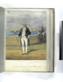
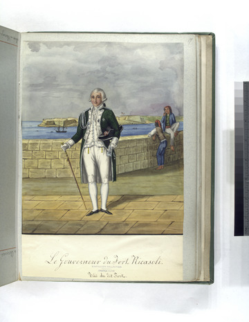
18th-century painting of the Hospitaller Governor of Fort Ricasoli, with the fort itself in the background
See also
 In Spanish: Fuerte Ricasoli para niños
