Fort San Pedro facts for kids
Quick facts for kids Fort San Pedro |
|
|---|---|
|
Moog ng San Pedro (Filipino)
|
|
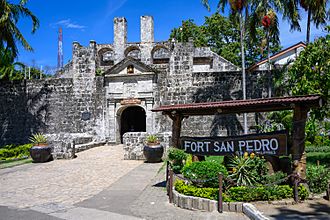
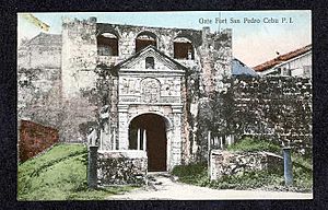
Front entrance of Fuerte de San Pedro
|
|
| Alternative names | Fuerte de San Pedro |
| General information | |
| Type | Bastioned fort |
| Architectural style | Italian-Spanish school of fortification |
| Location | Plaza Indepedencia |
| Town or city | Cebu |
| Country | Philippines |
| Coordinates | 10°17′32″N 123°54′21″E / 10.29222°N 123.90583°E |
| Construction started | 1565 |
| Technical details | |
| Structural system | Masonry |
| Floor area | 2,025 square metres (21,800 sq ft) |
| Designations | National Historical Landmark |
Fort San Pedro is a very old military fort in Cebu, Philippines. Spanish explorers built it to protect their settlement. It was first made of wood in 1565. Later, it was rebuilt with strong stone walls.
This fort is the oldest triangular fort in the Philippines. It has seen many important events in history. Today, it is a popular historical site. People visit to learn about its past and explore its grounds.
Contents
What is Fort San Pedro?
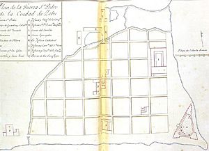
Fort San Pedro, also known as Fuerte de San Pedro, was built by the Spanish. It was started by Miguel López de Legazpi, who was the first Spanish governor in the Philippines. The fort is located near the pier in Cebu City.
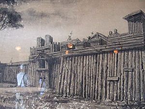
The original fort was made of wood. It was built soon after Legazpi and his team arrived. In the early 1600s, a stone fort was constructed. This was to defend against attacks from Muslim raiders.
How Was the Fort Built?
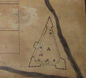
The fort has a unique triangular shape. Two sides face the sea, and the third side faces the land. The sea-facing sides had cannons for defense. The land side was protected by a strong wooden fence.
The fort has three main towers, called bastions. They are named La Concepción, Ignacio de Loyola, and San Miguel. The total area inside the fort is about 2,025 square meters.
The walls of the fort are about 6 meters (20 feet) high. They are also about 2.4 meters (8 feet) thick. The towers stand about 9 meters (30 feet) tall from the ground. The entire fort has a circumference of about 380 meters (1,248 feet).
A Look Inside the Fort
In 1739, the King of Spain asked for information about Cebu. Governor-General Tamón described the fort. He said it was made of stone and had a platform for cannons.
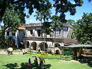
Inside the fort, there were important buildings. The Cuerpo de Guardia was where the soldiers lived. Next to it was the vivienda del teniente, which was the lieutenant's living area. There was also a well between these buildings. A powder magazine, called Almacenes de Pólvora, was located near the San Miguel bastion.
The Fort's Long History
The exact date the stone fort was finished is not fully known. Some say a Jesuit priest, Antonio Campioni, built a stone fort in 1630. The fort's gate shows the year 1738. It also has the symbols of the Spanish kingdoms of Castile and Leon.
The fort had big repairs in the late 1800s. This was part of a plan to make Cebu better.
Changing Hands: Americans and Filipinos
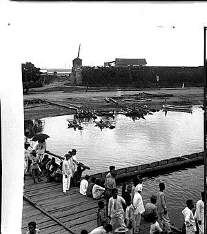
The Spanish era in the Philippines ended in 1898. This was after the Americans won the Battle of Manila Bay. The Spanish then gave Fort San Pedro to the Filipino revolutionaries in Cebu. The Filipinos used it as their stronghold.
Later, during the American rule, Fort San Pedro became part of the American Warwick barracks. From 1937 to 1941, it was even used as a school. Many Cebuanos got their education there.
World War II and Beyond
During World War II, from 1942 to 1945, Japanese people living in Cebu found shelter inside the fort. When the battle to free Cebu from the Japanese forces happened, the fort became an emergency hospital. It helped wounded people.
After the war, from 1946 to 1950, Fort San Pedro was an army camp. In 1950, the Cebu Garden Club took over. They cleaned up the inside and turned it into a small garden.
Saving and Restoring the Fort
In 1957, the mayor of Cebu wanted to tear down the fort. He planned to build a new city hall there. But many people and newspapers spoke out against this idea. The mayor then changed his mind.
By 1968, much of the fort was in ruins. Only two towers were still easy to recognize. Plans began to restore the fort to its original look. An architect named Leonardo Concepción created the plans.
The restoration project was a lot of hard work. Workers used coral stones from under the sea near Cebu. They cut and polished these stones to fit perfectly. After about a year and a half, the main entrance, the main building, and other parts were restored.
Fort San Pedro Today
Today, Fort San Pedro is managed by the Cebu City government. It is a historical park. The main building now serves as an office for the Department of Tourism. The lieutenant's quarters is a museum.
The inner courtyard is an open-air theater. The area around the fort is a park. The museum inside the fort displays Spanish artifacts. These include old documents, paintings, and sculptures. Outside the fort, you can see large statues of Legazpi and Antonio Pigafetta.
See also
 In Spanish: Fuerte de San Pedro para niños
- Fort San Pedro (Iloilo)
 | Bayard Rustin |
 | Jeannette Carter |
 | Jeremiah A. Brown |


