Fort Trois-Rivières facts for kids
Quick facts for kids Fort Trois-Rivières |
|
|---|---|
|
Fort des Trois-Rivières
|
|

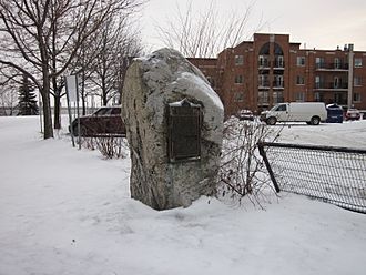
The monument marking Fort Trois-Rivières.
|
|
| General information | |
| Type | Fort |
| Location | Trois-Rivières, Quebec, Canada |
| Coordinates | 46°20′31″N 72°32′19″W / 46.341944°N 72.538611°W |
| Construction started | 1634 |
| Completed | 1638 |
| Demolished | 1668 |
| Official name: Fort Trois-Rivières National Historic Site of Canada | |
| Designated: | 1920 |
Fort Trois-Rivières (which means Fort of the Three Rivers in French) was an important wooden fort built in the 1600s. It was located in New France, which is now part of Canada. The fort was built between 1634 and 1638 by a man named Sieur de Laviolette.
Building this fort was a big step for New France. It became the second permanent settlement there. This settlement eventually grew into the modern city of Trois-Rivières, Quebec. Because of its historical importance, Fort Trois-Rivières was named a National Historic Site of Canada on January 30, 1920.
Contents
What Was Fort Trois-Rivières?
Fort Trois-Rivières was a strong wooden fort. It was built to protect the new settlement from attacks. The fort was surrounded by a tall fence made of pointed logs, called a palisade. This palisade helped protect the people inside.
Building a New Home
The construction of the fort started in 1634 and finished in 1638. It was a key part of establishing a lasting French presence in the area. The fort's location was chosen carefully, near the meeting point of three rivers, which gave the future city its name.
Protecting the Settlement
The fort's defenses were put to the test many times. In 1653, a large group of Iroquois warriors attacked the fort. However, the strong palisade and the brave defenders managed to fight them off. The fort was used to protect the settlement for many years.
Later, around 1650, the governor of New France, Louis d'Ailleboust de Coulonge, worked to make the fort even stronger. He gave specific instructions to the fort's commander, Pierre Boucher, to improve its defenses. These improvements helped the fort survive another major attack in 1653 by about five hundred Mohawks.
The Fort's End
Fort Trois-Rivières was used until 1668. In that year, a peace treaty was signed with the Iroquois. Because the threat of attacks was reduced, the fort was no longer needed for defense. It was then taken down.
Where Can You Find It Today?
Even though the fort is gone, its history is remembered. A special stone with a plaque is located south of the post office on des Casernes Street. This area is now called Platon Park. The plaque marks the general area where the fort once stood. The original boundaries of the fort were near today's Saint-Pierre, Saint-Jean, Saint-Louis, des Casernes, and Notre-Dame streets.

