Fostertown, New Jersey facts for kids
Quick facts for kids
Fostertown, New Jersey
|
|
|---|---|

Fostertown Road
|
|
| Country | |
| State | |
| County | Burlington |
| Township | Lumberton |
| Elevation | 12 m (39 ft) |
| Time zone | UTC−05:00 (Eastern (EST)) |
| • Summer (DST) | UTC−04:00 (EDT) |
| Area code(s) | 609 |
| GNIS feature ID | 876429 |
Fostertown is a small, quiet community. It is located within Lumberton Township. This township is in Burlington County, New Jersey. Fostertown is known as an unincorporated community. This means it's a place with a shared identity but without its own local government.
Contents
Discovering Fostertown's History
Fostertown has a long history. It was founded way back in 1735. A person named William Foster started the community. He created a large farm, called a plantation, on what is now West Bella Bridge Road.
What Fostertown Looks Like Today
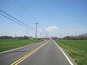
Today, Fostertown is mostly farmland. You can see many fields where crops grow. There are also some houses scattered around. A large power line also runs through the area.
Getting Around Fostertown
Fostertown has important roads and nearby airports. These help people travel to and from the community.
Major Roads in Fostertown
County Route 541 is a main road. It goes right through the middle of Fostertown. This road helps people get around the area easily.
Nearby Airports for Travel
There are two airports close to Fostertown. The Flying W Airport is located south of the community. Part of this airport is in Lumberton Township. The other part is in Medford. Another airport, the South Jersey Regional Airport, is west of Fostertown. These airports connect the community to other places.
 | Ernest Everett Just |
 | Mary Jackson |
 | Emmett Chappelle |
 | Marie Maynard Daly |


