Four Corners, Maryland facts for kids
Quick facts for kids
Four Corners, Maryland
|
|
|---|---|

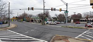
Intersection of MD 193 and its western turnaround in Four Corners
|
|
| Country | |
| State | |
| County | |
| Unincorporated community | Silver Spring |
| Area | |
| • Total | 1.48 sq mi (3.83 km2) |
| • Land | 1.46 sq mi (3.79 km2) |
| • Water | 0.01 sq mi (0.03 km2) |
| Elevation | 312 ft (95 m) |
| Population
(2020)
|
|
| • Total | 8,316 |
| • Density | 5,680.33/sq mi (2,193.89/km2) |
| ZIP Code |
20901
|
| Area codes | 301, 240 |
| FIPS code | 24-29790 |
| GNIS feature IDs | 2583623 |
Four Corners is a neighborhood in Montgomery County, Maryland, United States. It is also known as a census-designated place (CDP). This means it is an area that the government defines for gathering population information. Many people who live here think of Four Corners as part of Silver Spring. In 2020, about 8,316 people lived in Four Corners.
| Top - 0-9 A B C D E F G H I J K L M N O P Q R S T U V W X Y Z |
Where is Four Corners?
Four Corners is located in Maryland. Its borders are Dennis Avenue to the northwest and the Northwest Branch Trail to the northeast. To the south, it is bordered by Interstate 495 (Capital Beltway).
It is next to other neighborhoods like Woodmoor and Indian Spring Village. Other nearby areas include Franklin Knolls, Indian Spring Terrace, North Hills Sligo Park, and Burnt Mills Hills. The community of Northwood Park is also part of Four Corners. Sometimes, people call it Northwood-Four Corners or just North Four Corners.
Cool Places in Four Corners
Four Corners has some interesting landmarks and places to visit.
Montgomery Blair High School
Montgomery Blair High School is a public high school in the area. It is named after Montgomery Blair. He was a lawyer who worked for President Abraham Lincoln. The school is well-known for its special programs. These include a magnet program for advanced students and a Communication Arts Program (CAP).
Polychrome Historic District
The Polychrome Historic District is a special historic area in Four Corners. It includes five unique houses. These homes were built by John Joseph Earley in 1934 and 1935. They are recognized for their special design and history.
North Four Corners Park
North Four Corners Park is a large park that covers 14 acres. The land for the park was first bought in the mid-1940s. During World War II, temporary homes for military families were built there. Today, the park is a great place for fun activities. It has a recreation building, a playground, and fields for sports. You can also find tennis courts and a picnic area there.
Historic Homes
There are several old and interesting homes in North Four Corners. One is the Silver Spring 1939 World’s Fair Home. It was House No. 15 in the 'Town of Tomorrow' exhibit. Another is the brick Tudor Revival Washington Gas Model Home. This house was part of a building program that started in 1938 in Northwood Park.
History of Four Corners
Four Corners has a long and interesting history, going back to the 1700s.
The Burnt Mills Area
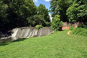
In the 1700s, a water mill was built in the eastern part of Four Corners. This was where Colesville Road crosses the Northwest Branch of the Anacostia River. The mill burned down in 1788, which is how the name "Burnt Mills" came about. It was rebuilt later.
In the early 1900s, the land was given to the Boy Scouts of America. They set up a camp there. Later, the Boy Scouts donated part of the land for a water treatment plant. This plant, called the Robert B. Morse Filtration Plant, was finished in 1936. The dam and two old pump houses are now historic sites. The Burnt Mills Dam parks are a popular spot for hikers. They can start their walk on the Northwest Branch Trail from here. This trail is part of the Rachel Carson Greenway.
Growth of the Neighborhood
In the 1800s, Four Corners was a farming community. It stayed mostly rural until after World War I. Then, many new homes were built in Montgomery County. Four Corners became a residential neighborhood between the two World Wars. This started in the late 1930s with new housing developments like Northwood Park and Woodmoor.
More neighborhoods were built between 1945 and 1955, such as Northwood and Franklin Knolls. The streets in these areas were often winding, creating a unique pattern. By the late 1950s, Four Corners was mostly developed into the neighborhood we see today.
Getting Around Four Corners
Four Corners has several ways to get around using public transportation.
You can use Metrobus lines Z6, Z8, C2, and C4. There are also Ride On buses, including numbers 8, 9, and 19, and the Flash BRT. For longer trips, the Washington Metro's Red Line is available. You can catch it at the nearby Wheaton and Silver Spring stations.
A new train line, the Purple Line, is being built. The Piney Branch Road station will be close by. It is expected to open to the public by 2027.
Population of Four Corners
The population of Four Corners has grown over the years.
- In 2010, the population was 7,945 people.
- In 2020, the population was 8,316 people.
The people living in Four Corners come from many different backgrounds. In 2010, about 67% of residents were White, 12.6% were African American, and 7.2% were Asian. About 17.7% of the population identified as Hispanic or Latino.
See also
 In Spanish: Four Corners (Maryland) para niños
 | Jackie Robinson |
 | Jack Johnson |
 | Althea Gibson |
 | Arthur Ashe |
 | Muhammad Ali |


