Northwest Branch Anacostia River facts for kids
Quick facts for kids Northwest Branch Anacostia River |
|
|---|---|

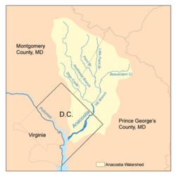
Map of the Anacostia River watershed showing the Northwest Branch
|
|
| Country | United States |
| State | Maryland |
| Cities | Wheaton, Silver Spring, Hyattsville |
| Physical characteristics | |
| Main source | Sandy Spring, Maryland |
| River mouth | Anacostia River Bladensburg, MD 38°56′34″N 76°56′39″W / 38.942832°N 76.944036°W |
| Length | 21.5 mi (34.6 km) |
| Basin features | |
| Basin size | 53.5 sq mi (139 km2) |
| Tributaries |
|
The Northwest Branch Anacostia River is a 21.5-mile (34.6 km) long stream in Maryland. It flows freely through Montgomery County and Prince George's County. This river is like a smaller "arm" that feeds into the Anacostia River. The Anacostia River then joins the Potomac River, which eventually flows into the Chesapeake Bay. So, the Northwest Branch is part of a much larger water system!
Contents
The River's Journey
The Northwest Branch starts near a place called Sandy Spring. From there, it flows south for about 21.5 miles (34.6 km). It eventually meets up with the Northeast Branch near Bladensburg. When these two branches meet, they form the main part of the Anacostia River.
What is a Watershed?
A watershed is like a giant bowl that collects all the rain and snowmelt in an area. All this water then drains into a single river or stream. The Northwest Branch Anacostia River has its own watershed.
Communities in the Watershed
The Northwest Branch watershed covers parts of many communities. In Montgomery County, these include Norwood, Bel Pre Manor, Colesville, Layhill, Glenmont, Wheaton, Hillandale, White Oak, Silver Spring, Kemp Mill, Four Corners, and Takoma Park.
In Prince George's County, the watershed includes Adelphi, Langley Park, University Park, Chillum, Hyattsville, Avondale, and Brentwood. A tiny part of the watershed is also in Washington, D.C..
Size and Population
The total area of the Northwest Branch watershed is about 53.5 square miles (138.6 square km). Around 254,000 people live in this area. This means many people live near and depend on the health of this river!
Protecting the River: Rachel Carson Greenway
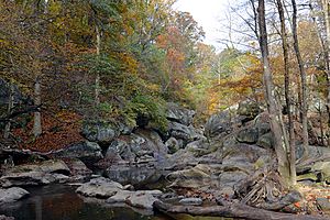
A special part of the Northwest Branch is called the Rachel Carson Environmental Area. This area is named after Rachel Carson, a famous environmental writer. It's kept wild and natural, flowing through a small gorge under the Capital Beltway.
The land along most of the Northwest Branch is protected as parkland. This helps keep the river healthy. The Maryland-National Capital Park and Planning Commission (M-NCPPC) plans to extend the Northwest Branch Trail into northern Montgomery County. This trail will be a natural hiking path, connecting to other trails in the area.
River's Geology: The Fall Line
The Northwest Branch crosses a special geological spot called the fall line. This is where the rocky Piedmont region meets the flatter Atlantic coastal plain. At this spot, the river forms a small waterfall. This waterfall is about 0.5 miles (0.8 km) south of the Burnt Mills Dam parks. This area was a favorite place for former U.S. President Theodore Roosevelt.
Smaller Streams Joining the River
The Northwest Branch is fed by many smaller streams, called tributaries. If you add up the length of the Northwest Branch and all its tributaries, it's about 75 miles (121 km) long!
Here are some of the streams that flow into the Northwest Branch:
- Bachelors Forest Tributary
- Bel Pre Creek
- Bryants Nursery Tributary
- Lamberton Drive Tributary
- Lockridge Drive Tributary
- Longmeade Tributary
- Norwood Tributary
- Old Orchard Tributary
- Rolling Stone Tributary
- Sandy Spring Tributary
- Sligo Creek
- Wheaton Park Tributary
 | Sharif Bey |
 | Hale Woodruff |
 | Richmond Barthé |
 | Purvis Young |


