Sligo Creek facts for kids
Quick facts for kids Sligo Creek |
|
|---|---|

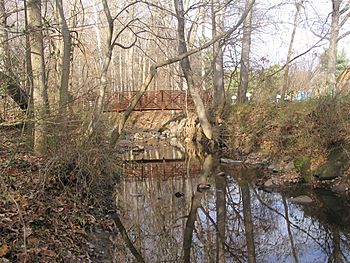
The creek running through Silver Spring, Maryland
|
|

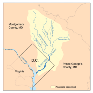
Map of the Anacostia River watershed showing Sligo Creek
|
|
| Country | United States |
| State | Maryland |
| City | Silver Spring, Maryland |
| Physical characteristics | |
| Main source | Kemp Mill, Maryland 450 ft (140 m) |
| River mouth | Northwest Branch Hyattsville, Maryland 35 ft (11 m) 38°57′32″N 76°58′26″W / 38.959°N 76.974°W |
| Length | 9.1 mi (14.6 km) |
| Basin features | |
| Basin size | 11.6 sq mi (30 km2) |
| Tributaries |
|
Sligo Creek is a stream in Maryland that flows into the Northwest Branch of the Anacostia River. The Anacostia River then joins the Potomac River, which eventually flows into the Chesapeake Bay and then the Atlantic Ocean.
Sligo Creek is about 9.1 miles (14.6 km) long. The area of land that drains water into the creek, called its watershed, is about 11.6 square miles (30.0 km2).
Contents
Where Sligo Creek Flows
Sligo Creek starts in the Kemp Mill area of Silver Spring in Montgomery County. It then flows southeast and joins the Northwest Branch near Hyattsville in Prince George's County.
In some parts, especially closer to where it meets the Northwest Branch, the creek's path has been made straighter by people. The land around the creek goes from about 450 feet (137 meters) above sea level at its start to 35 feet (11 meters) where it joins the Northwest Branch.
Streams that Join Sligo Creek
Several smaller streams flow into Sligo Creek. These are called tributaries. They include:
- Wheaton Branch
- Comstock Branch
- Takoma Park Branch
- Long Branch
Urban Areas and Nature Along the Creek
Sligo Creek flows through many towns, including Silver Spring, Wheaton, Takoma Park, Carole Highlands, Chillum, and Hyattsville.
The area around Sligo Creek is very developed, with many buildings and people. About 75% of the land that drains into the creek is in Montgomery County, 20% is in Prince George's County, and 5% is in Washington, D.C.. Less than 15% of the land is undeveloped, and only about 10% is covered by forests.
In many places, the land along the creek is kept as public parkland. You can find grassy areas and playing fields there.
Trails and Parkways
The Sligo Creek Trail is a popular path for hikers and bikers. It runs along the creek from Wheaton all the way to where Sligo Creek meets the Northwest Branch. From there, it connects to the larger Anacostia Tributary Trail System.
An automobile parkway (a scenic road) also runs alongside many parts of the creek in Montgomery County.
Protecting Sligo Creek's Water
Because the Sligo Creek watershed has so many buildings and roads, the water quality in the creek and its smaller streams has been affected. In 2002, the Maryland Department of the Environment (MDE) said the creek's water quality was poor.
To help fix this, the Montgomery County Government started projects in 1989 to manage stormwater (rainwater runoff) and restore the stream. By 2009, the MDE noticed some improvements in the creek's water quality. The county continues to work on these projects to make the creek healthier.
History of Sligo Creek
Sligo Creek got its name from a crossroads called "Sligo." This crossroads was started in the mid-1800s by Irish immigrant workers who were building the C&O Canal. It might have been named after County Sligo in Ireland. The original Sligo crossroads was located where Colesville Road and Georgia Avenue are today in Silver Spring.
During the Civil War, the Sligo crossroads had a toll gate, an inn, and a post office. Sligo Creek itself is about half a mile from this historic crossroads.
Past Uses of the Creek
Over the years, Sligo Creek has been used for many things by local residents:
- It powered grist mills, which ground grain into flour.
- It was a source of drinking water.
Near Washington Adventist University in Takoma Park, you can still see the remains of a dam and buildings from the Sligo Creek Waterworks. From 1900 to 1930, this waterworks provided public drinking water to the city of Takoma Park. It was one of the first public water systems in the area.
Another dam was located where Flower Avenue crosses Sligo Creek. This dam helped power Sligo Mill, which was built in 1812. Besides grinding grain, Sligo Mill also made whiskey. The mill was taken down in the 1920s.
In 1900, the Glen Sligo Hotel and Wildwood Amusement Park were built overlooking the Sligo Mill dam and pond. However, they only operated for a few years, closing in 1903.
Sligo Creek in Music and Books
Sligo Creek has inspired many artists:
- John Fahey, a guitarist from Takoma Park, wrote a song called "Sligo River Blues."
- Danny Noveck, a musician who lived near the creek, composed an Irish traditional tune called "Sligo Creek."
- Another folk guitarist, Al Petteway, also composed a song named "Sligo Creek." This song was later used as the theme music for The National Parks, a PBS TV series directed by Ken Burns.
- The creek, where her son and his friends played, helped inspire Katherine Paterson's famous book, Bridge to Terabithia. This book won the Newbery Medal.
 | Valerie Thomas |
 | Frederick McKinley Jones |
 | George Edward Alcorn Jr. |
 | Thomas Mensah |


