Northeast Branch Anacostia River facts for kids
Quick facts for kids Northeast Branch Anacostia River |
|
|---|---|

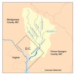
Map of the Anacostia River watershed showing the Northeast Branch
|
|
| Country | United States |
| State | Maryland |
| Cities | Beltsville, Greenbelt, College Park, Hyattsville |
| Physical characteristics | |
| Main source | Paint Branch Maryland 38°58′43″N 76°55′01″W / 38.9786111°N 76.9169444°W |
| River mouth | Anacostia River Bladensburg 38°56′33″N 76°56′37″W / 38.9426111°N 76.9435856°W |
| Length | 3 mi (4.8 km) |
| Basin features | |
| Basin size | 75.6 sq mi (196 km2) |
| Tributaries |
|
The Northeast Branch Anacostia River is a natural river in Prince George's County, Maryland. It flows freely for about 3.2 miles (5.1 km). This river is a smaller stream that flows into the Anacostia River. The Anacostia River then joins the Potomac River, which eventually reaches the Chesapeake Bay.
Where the River Flows
The Northeast Branch Anacostia River starts where two smaller streams, Indian Creek and Paint Branch, meet. This meeting point is on the eastern edge of College Park.
From there, the river flows south for about 3 miles (4.8 km). It then meets another river, the Northwest Branch. These two rivers join near Bladensburg to form the main part of the Anacostia River.
The River's Watershed
A watershed is an area of land where all the water drains into a specific river or stream. The Northeast Branch Anacostia River's watershed is in Prince George's County. It includes parts of several communities. These are Beltsville, Greenbelt, College Park, New Carrollton, Riverdale Park, Hyattsville, Berwyn Heights, and Edmonston.
Some smaller streams, like Paint Branch and Little Paint Branch, also bring water from other areas. These areas are in Montgomery County. Important places in the watershed include the Beltsville Agricultural Research Center and the University of Maryland, College Park. Greenbelt Park is also part of this area. The entire watershed covers about 75.6 square miles (196 km²). Around 246,530 people live in this area.
River's Geology
The Northeast Branch is located in a flat, low-lying area. This area is known as the Atlantic coastal plain geologic region. It is close to the Atlantic Ocean.
Streams Joining the River
Many smaller streams flow into the Northeast Branch. If you add up the length of the Northeast Branch and all these smaller streams, the total length is about 12.1 miles (19.5 km).
Here are some of the streams that join the Northeast Branch:
- Brier Ditch
- Indian Creek
- Little Paint Branch
- Paint Branch
- Still Creek
- Upper Beaverdam Creek
 | Misty Copeland |
 | Raven Wilkinson |
 | Debra Austin |
 | Aesha Ash |

