
College Park, Maryland facts for kids
Quick facts for kids
College Park, Maryland
|
|||
|---|---|---|---|
|
College Park City Hall
Memorial Chapel
NOAA Weather Prediction Center
|
|||
|
|||
 |
|||

College Park, Maryland
Location in Maryland

College Park, Maryland
Location in the United States
|
|||
| Country | |||
| State | |||
| County | Prince George's | ||
| Founded | 1856 | ||
| Incorporated | 1945 | ||
| Government | |||
| • Type | Council–manager | ||
| Area | |||
| • Total | 5.68 sq mi (14.72 km2) | ||
| • Land | 5.61 sq mi (14.53 km2) | ||
| • Water | 0.07 sq mi (0.18 km2) | ||
| Elevation | 69 ft (21 m) | ||
| Population
(2020)
|
|||
| • Total | 34,740 | ||
| • Density | 6,191.41/sq mi (2,390.37/km2) | ||
| Time zone | UTC−5 (EST) | ||
| • Summer (DST) | UTC−4 (EDT) | ||
| ZIP Codes |
20740–20742
|
||
| Area code | 301, 240 | ||
| FIPS code | 24-18750 | ||
| GNIS feature ID | 2390578 | ||
| Website | www.collegeparkmd.gov | ||


College Park is a city in Prince George's County, Maryland, United States. It is about 4 miles (6.4 km) from the northeast edge of Washington, D.C.. In 2020, about 34,740 people lived there.
College Park is famous for being the home of the University of Maryland, College Park. It also has important federal offices like the National Archives at College Park and the NOAA's Weather Prediction Center. Some cool tech companies, like IonQ (which works on quantum computing), are also located here.
The College Park Airport, started in 1909, is the oldest airport in the world that has been open continuously. Next to the airport is the College Park Aviation Museum. This museum is connected to the Smithsonian Institution and shows off old airplanes and items about early flight.
In 2014, the University of Maryland began a big project called the Greater College Park initiative. This project is a $2 billion plan to make the area around the university better. It aims to create a lively "Discovery District" and one of the best college towns in the country. Because of this, College Park is seeing many new homes, offices, schools, stores, and restaurants.
Contents
History of College Park
How College Park Grew
College Park started to develop in 1889. It was built near the Maryland Agricultural College (which later became the University of Maryland) and a train stop. The area officially became a city in 1945. It included several smaller neighborhoods like Lakeland and Hollywood.
The first plans for College Park were made in 1872. But the area didn't really grow until 1889, when two real estate developers from Washington, D.C., replanned it. They divided the land into a grid of streets with long, narrow building lots. College Park grew quickly because people wanted to escape crowded Washington, D.C., and many college staff needed places to live.
At first, College Park had single-family homes in popular styles of the time. More businesses opened in the 1920s as more cars used Baltimore Avenue / Route 1. After World War II, many new homes were built. The city continued to grow after it became official in 1945, and a city hall was built in 1959.
The Lakeland neighborhood began in 1890 near the train tracks. It was first planned as a resort area. But because the land was low and often flooded, it became a community for African-American families. Around 1900, a company built five artificial lakes there to raise goldfish. By 1903, Lakeland was a strong African-American community with its own school and churches.
The Berwyn neighborhood started around 1885 next to the train tracks. A man from Pennsylvania bought land and built a store and about 15 homes. This was to attract families who wanted to move out of Washington. The area grew more after 1900 when an electric streetcar line came through. By 1925, there were about 100 homes.
The Daniels Park neighborhood began in 1905. It was a small area with single-family houses built in a grid pattern. The houses were built between 1905 and the 1930s.
The Hollywood neighborhood also developed in the early 20th century along the streetcar line. It grew slowly until after World War II. Then, a developer built many brick and wood homes starting in 1950. An elementary school was built in 1952. Hollywood Neighborhood Park is a 21-acre (8.5 ha) park in the area.
Important Events in College Park
In 1943, during World War II, the Washington Senators baseball team held their spring training in College Park. This was because of rules to save train travel during the war.
From the 1960s to the 1980s, a project called Urban Renewal changed the historic African-American community of Lakeland. This project moved 104 of Lakeland's 150 families, even though many residents did not want it.
On September 24, 2001, a strong tornado hit College Park. It caused a lot of damage on the University of Maryland campus. The tornado traveled for 17.5 miles (28.2 km). It caused two deaths and 55 injuries, and $101 million in property damage. The two people who died were University of Maryland students.

Around the year 2000, College Park started to change a lot. People felt the city needed more fun things to do and a better community feel. In 2002, a plan was made to allow new types of buildings along College Park's main road, Route 1. New projects like student apartments and hotels are helping the city become a more exciting place. In 2004, College Park also added 72 acres (29 ha) of land that used to be part of Beltsville. This new area included a Holiday Inn and an IKEA.
Students from the University of Maryland helped imagine the future of College Park in 2006. A group of students also created "Rethink College Park" to share information about new developments.
Since 2009, new buildings have been added, including a parking garage, student apartment towers with shops, and The Hotel at the University of Maryland.
As of 2020, the University of Maryland is building many new things on campus. These include additions to the chemistry building, a sports and medicine complex, a new public policy school, and an "IDEA Factory."
On June 9, 2020, the city government officially apologized for past unfair treatment of the Lakeland community. They promised to work towards fairness and justice.
Geography and Climate
College Park is located at 38°59′48″N 76°55′39″W / 38.99667°N 76.92750°W.
The city covers a total area of 5.68 square miles (14.72 km2). Most of this area is land, with a small part being water.
What is the Climate Like?
The weather in College Park has hot, humid summers. Winters are usually mild to cool. It has a humid subtropical climate, which means it gets plenty of rain and has warm temperatures for much of the year.
Neighborhoods in College Park
College Park has many different neighborhoods, including:
- Autoville/Cherry Hill
- Berwyn
- Branchville
- Calvert Hills
- College Park Woods
- Crystal Springs/Patricia Court
- Daniels Park
- Hollywood
- Lakeland
- North College Park
- Old Town
- Sunnyside
- Yarrow
Nearby Areas
College Park is next to several other towns:
- Beltsville (North)
- Berwyn Heights (East)
- University Park (Southwest)
- Riverdale Park (South)
- Adelphi (West)
- Hyattsville (Southwest)
People and Population
| Historical population | |||
|---|---|---|---|
| Census | Pop. | %± | |
| 1950 | 11,170 | — | |
| 1960 | 18,482 | 65.5% | |
| 1970 | 26,156 | 41.5% | |
| 1980 | 23,614 | −9.7% | |
| 1990 | 21,927 | −7.1% | |
| 2000 | 24,657 | 12.5% | |
| 2010 | 30,413 | 23.3% | |
| 2020 | 34,740 | 14.2% | |
| U.S. Decennial Census | |||
In 2020, College Park had 34,740 people. The city is very diverse. About 47.79% of the people were White, 14.60% were Black or African American, and 17.13% were Asian. About 15.34% of the population was Hispanic or Latino.
The average income for a household in the city was about $50,168. For families, it was about $62,759.
Economy and Jobs

The University of Maryland, College Park plays a huge role in College Park's economy. It provides more than half of the jobs in the city. In 2017, the university renamed its business and research park the Discovery District. This area aims to bring together research companies, new businesses, shops, and restaurants.
The Discovery District is home to federal agencies like NOAA's Weather Prediction Center and the FDA's Center for Food Safety and Applied Nutrition. It also has university research centers.
Many technology companies are in the Discovery District, often connected to the university. Quantum technology has grown very fast here since 2010. Companies like IonQ (a quantum computing company) are part of this growth. The university wants to make College Park the "capital of quantum" technology.
Other growing areas in the Discovery District include cybersecurity and medical devices. In 2023, the Washington Commanders football team announced they would move their headquarters to the Discovery District in 2024. This area is considered one of the most important economic centers in the county.
Who are the Biggest Employers?


Here are the top employers in College Park as of 2023:
- University of Maryland, College Park: 14,505 employees (almost half of all jobs in the city!)
- University of Maryland Global Campus: 1,037 employees
- National Oceanic and Atmospheric Administration: 900 employees
- Food and Drug Administration: 755 employees
- National Archives and Records Administration: 732 employees
- IKEA: 500 employees
- IonQ: 200 employees
- The Home Depot: 170 employees
- The Hotel at the University of Maryland: 155 employees
- American Center for Physics: 142 employees
Culture and Fun
College Park holds several fun events each year. College Park Day happens in October at the College Park Aviation Museum & Airport. It's a big event with activities, entertainment, and food. Other events include the College Park Parade, Friday Night Live! (with music and food in the summer), and Winter Wonderland (a holiday market and tree lighting).
During spring and summer, farmer markets sell local produce, meats, baked goods, and crafts.
-
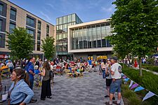
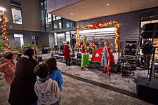
Friday Night Life! at the City Hall plaza
-
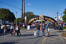
Entrance at the College Park day
-
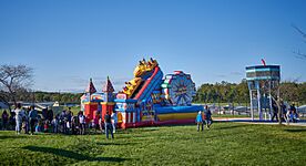
Inflatable at the College Park day with the airport in the background
-
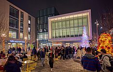
Tree lighting at the Winter Wonderland
-
Grinch at the College Park Winter Wonderland


Performing Arts and Music
The University of Maryland campus has many places for performing arts. The Clarice Smith Performing Arts Center is a huge building with six performance spaces. The Adele H. Stamp Student Union also has a theater and ballroom for events. There's even an outdoor amphitheater for performances.
Big sports venues like the Jones-Hill House, Ritchie Coliseum, and XFINITY Center also host concerts. Famous artists like Bruce Springsteen, Elvis Presley, Queen, and U2 have performed here!
Other places in College Park that host cultural events include the Old Parish House and The Hall CP restaurant.
Museums to Explore

The College Park Aviation Museum is a great place to learn about flight. It has old airplanes and lots of information about the history of the College Park Airport and early aviation.
Other museums include the Art Gallery at the University of Maryland and the National Museum of Language. This museum explores the history and art of language.
Historic Places to See
College Park has many historic sites. Here are some of the oldest ones:
- The Rossborough Inn (1803): This was a popular stop for travelers on the road between Baltimore and Washington.
- Old Parish House (1817): This building was first a farm building and later used for community events.
- Cory House (1891): One of the first houses built in the original College Park area.
- Morrill Hall (1892): A building at the University of Maryland, named after a politician.
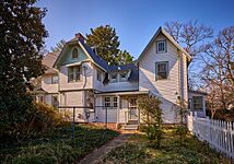
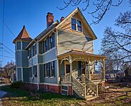
- Taliaferro House (1893): The home of Emily Taliaferro, whose father helped develop College Park.
- Lake House (1894): Built by the Lake family, it later became a church parsonage.
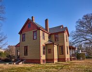
- McDonnell House (1896): Built for Henry B. McDonnell, the first Dean of Arts and Sciences at the University of Maryland.
-
The Rossborough Inn (1803), oldest building in College Park
-
The Old Parish House, built in 1817
-
The Cory House, built in 1891
-
The Lake House, built in 1894
-
The McDonnell House, built in 1896


Food and Restaurants
College Park has many different kinds of restaurants. You can find Chinese, Mexican, and many other international foods. In recent years, the food scene has grown a lot, with more fancy restaurants and Asian food options. This is part of an effort to make the Route 1 area more appealing to professionals.
Sports and Recreation


Sports in College Park mostly revolve around the University of Maryland. Their teams compete in NCAA Division I and have won over 44 national championships! The university's sports facilities are considered some of the best in the nation. The biggest ones are the SECU Stadium for football and lacrosse, and the XFINITY Center for basketball.
College Park has 11 parks. The most popular is Lake Artemesia, a 38-acre (15 ha) lake. It has gardens, fishing spots, and a 1.35-mile (2.17 km) trail around it. The lake is a great place for birdwatching, with over 220 different bird species. The trails connect to other paths, making College Park a hub for outdoor activities.
Runners and walkers often meet for the College Park parkrun every Saturday. This is a timed 5 km (3.1 mi) event. It's one of the largest parkrun events in the United States.
College Park also has a strong culture of board gaming and game design. The popular board game Wingspan was inspired by birdwatching at Lake Artemesia. It was even partly developed at Board and Brew, one of the oldest board game cafés in the U.S.
Other fun places include the Junior Tennis Champions Center (JTCC), a tennis training center, and the Ellen E. Linson Splash Park for swimming. There's also the Herbert Wells Ice Rink for ice skating.
Education in College Park
Colleges and Universities

The main university in College Park is the University of Maryland, College Park. It is the biggest university in Maryland and the Washington, D.C. area, with over 40,000 students.
The headquarters for the University of Maryland Global Campus are also nearby. This is the largest online public university in the U.S.
Schools for Kids
Public Schools
College Park is part of the Prince George's County Public Schools system. Students go to different elementary, middle, and high schools in College Park and nearby towns.
The College Park Academy is a charter school for grades 6-12. It was started in 2013 to improve local public schools.

Private Schools
Some private schools in the area include:
- Dar-us-Salaam/Al Huda School, K–12
- Berwyn Baptist School, PreK–8
- Friends Community School, K–8
- Holy Redeemer School, PreK–8
- Laurel Springs School at Junior Tennis Champions Center, K–12
- Saint Francis International School St. Mark Campus, K–8
Media and News
College Park is part of the Washington, D.C. television market. Here are some local media sources:
- The Diamondback: This is the student newspaper for the University of Maryland. It used to be printed but is now only online.
- College Park: Here & Now: A free monthly newspaper that started in 2020.
- UMTV: A TV station run by the University of Maryland's journalism school.
- WMUC: A radio station that broadcasts from the University of Maryland campus. You can also listen online.
- Radio College Park: The oldest Persian podcast, made by Iranian students at the University of Maryland.
Getting Around College Park
Roads and Highways

U.S. Route 1, also called Baltimore Avenue, is the main road through College Park. It connects the city to Washington, D.C., and other nearby towns. In North College Park, Route 1 connects to Interstate 95 and Interstate 495, which is a big highway that goes around Washington, D.C.
Other important roads include Maryland State Route 193 and MD 431.
Biking Trails

College Park has many miles of trails for biking and walking. The most popular is the Rhode Island Avenue Trolley Trail. This 3.8-mile (6.1 km) trail follows the path of old streetcar lines that used to connect College Park to Washington, D.C.
Other trails include the Lake Artemesia trail, the Paint Branch trail, and the Indian Creek trail. These trails connect to a larger system called the Anacostia Tributary Trail System. This means you can bike to places like Washington, D.C., or Silver Spring on dedicated paths. College Park is known as one of the most bike-friendly cities in Maryland.
Airports

College Park Airport is very special because it's the oldest airport in the United States that has been open continuously since 1909. It was where the U.S. government first trained pilots for military purposes. The airport is listed on the National Register of Historic Places.
For bigger flights, people use Baltimore-Washington International Airport, Reagan National Airport, and Washington Dulles International Airport.
Public Transportation

College Park has a Washington Metro station called College Park–University of Maryland Station. It's on the Green Line. There's also a MARC commuter train stop right next to the Metro station.
Soon, five new Purple Line light rail stations will serve College Park. This new line will connect the Metro's Red, Green, and Orange lines, making it even easier to travel around the area. University of Maryland students and staff will be able to ride for free between these stops.
See also
 In Spanish: College Park (Maryland) para niños
