Fowlerville, Livingston County, New York facts for kids
Quick facts for kids
Fowlerville, New York
|
|
|---|---|
| Country | United States |
| State | New York |
| County | Livingston |
| Town | York |
| Area | |
| • Total | 0.90 sq mi (2.33 km2) |
| • Land | 0.90 sq mi (2.33 km2) |
| • Water | 0.00 sq mi (0.00 km2) |
| Elevation | 636 ft (194 m) |
| Population
(2020)
|
|
| • Total | 163 |
| • Density | 180.91/sq mi (69.83/km2) |
| Time zone | UTC-5 (Eastern (EST)) |
| • Summer (DST) | UTC-4 (EDT) |
| Area code | 585 |
| FIPS code | 36-27133 |
| GNIS feature ID | 950550 |
Fowlerville is a small community known as a hamlet in Livingston County, New York, United States. It is also called a census-designated place (CDP). This means it's an area the government defines for counting people. In 2020, about 163 people lived there.
The community was named after Wells Fowler, who was the first person to settle there.
It's important not to confuse this Fowlerville with other places in New York that have similar names. There are other hamlets named Fowlerville in Erie County and Sullivan County. There's also a place called Fowlersville in Lewis County.
Contents
Where is Fowlerville Located?
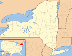
Fowlerville is found in the northwestern part of Livingston County. It is in the northeastern section of the town of York. The community sits at an elevation of about 636 feet (194 meters) above sea level.
Nearby Towns and Cities
Fowlerville is about 3 miles (5 km) northeast of the York hamlet. It is also about 8 miles (13 km) northwest of Geneseo, which is the main town for Livingston County. Other nearby places include Avon, about 6 miles (10 km) to the west, and the larger city of Rochester, about 24 miles (39 km) southwest.
Size of the Area
According to the 2010 United States Census, the Fowlerville CDP covers a total area of 0.90 square miles (2.33 square kilometers). All of this area is land, meaning there are no large bodies of water within its boundaries.
How Many People Live Here?
The number of people living in Fowlerville is counted during the United States Census.
Population Changes Over Time
The population of Fowlerville was 227 people in 2010. By the year 2020, the population had changed to 163 people. This information helps us understand how the community has grown or shrunk over time.
| Historical population | |||
|---|---|---|---|
| Census | Pop. | %± | |
| 2020 | 163 | — | |
| U.S. Decennial Census | |||
See also
 In Spanish: Fowlerville (Nueva York) para niños
 | Calvin Brent |
 | Walter T. Bailey |
 | Martha Cassell Thompson |
 | Alberta Jeannette Cassell |


