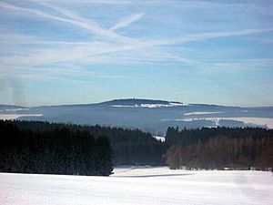
Franconian Forest facts for kids
The Franconian Forest (which is Frankenwald in German) is a beautiful, mid-sized mountain range located in Northern Bavaria, Germany. It's a special place known for its thick forests and rolling hills. This area connects two other important natural regions: the Fichtelgebirge and the Thuringian Forest.
What is the Franconian Forest?
The Franconian Forest is mostly a wide, forested plateau. A plateau is like a flat-topped mountain or a high, flat area of land. This plateau stretches for about 45 kilometers (around 28 miles) in a northwest direction. It gently slopes down towards the Saale river on its northern and eastern sides. However, it drops much more steeply towards the Bavarian plain on its western side.
Highest Point and Rivers
The highest point in the Franconian Forest is a mountain called the Döbraberg. It stands tall at 794 meters (about 2,605 feet) above sea level. You can find the Döbraberg near the town of Schwarzenbach am Wald.
Right through the middle of the Franconian Forest runs a very important line called a watershed. Imagine a roof: rain falling on one side goes one way, and rain falling on the other side goes another way. A watershed is similar for rivers. Here, water on one side flows into the Main River, which eventually joins the Rhine River. Water on the other side flows into the Saale River, which then connects to the Elbe River. This means the Franconian Forest helps decide where a lot of water in Germany ends up!
See also
 In Spanish: Selva de Franconia para niños
 | George Robert Carruthers |
 | Patricia Bath |
 | Jan Ernst Matzeliger |
 | Alexander Miles |


