Frankenfield Glacier facts for kids
Quick facts for kids Frankenfield Glacier |
|
|---|---|

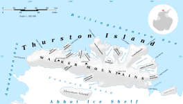
Map of Thurston Island
|
|
| Location | Ellsworth Land |
| Coordinates | 71°52′00″S 98°13′00″W / 71.86667°S 98.21667°W |
| Thickness | unknown |
| Terminus | Bellingshausen Sea |
| Status | unknown |
The Frankenfield Glacier (71°52′S 98°13′W / 71.867°S 98.217°W) is a small glacier in Antarctica. You can find it in the northeast part of Noville Peninsula, on Thurston Island. This glacier flows towards the east-northeast. It ends in the Bellingshausen Sea, located between Mount Feury and Mulroy Island.
Discovering Frankenfield Glacier
How the Glacier Was Found
Scientists first learned about Frankenfield Glacier from air photos. These pictures were taken by the U.S. Navy Operation Highjump. This important mission happened in December 1946. The photos helped them map out the glacier's general shape.
Who Was It Named After?
The glacier was named by a group called the Advisory Committee on Antarctic Names. They chose to name it after Lieutenant Chester Frankenfield. He was a meteorologist, which means he studied weather. Lieutenant Frankenfield was part of the U.S. Navy Bellingshausen Sea Expedition. In February 1960, he set up a special automated weather station on Thurston Island. This station helped collect important weather information.


