Freeman Spur, Illinois facts for kids
Quick facts for kids
Freeman Spur, Illinois
|
|
|---|---|

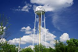
Water tower
|
|

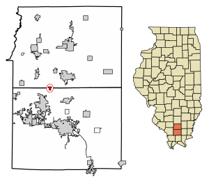
Location of Freeman Spur in Williamson & Franklin Counties, Illinois.
|
|

Location of Illinois in the United States
|
|
| Country | United States |
| State | Illinois |
| Counties | Williamson, Franklin |
| Townships | Denning, Herrin Precinct |
| Area | |
| • Total | 0.40 sq mi (1.04 km2) |
| • Land | 0.40 sq mi (1.03 km2) |
| • Water | 0.00 sq mi (0.01 km2) |
| Elevation | 390 ft (120 m) |
| Population
(2020)
|
|
| • Total | 268 |
| • Density | 671.68/sq mi (259.04/km2) |
| Time zone | UTC-6 (CST) |
| • Summer (DST) | UTC-5 (CDT) |
| ZIP Code |
62841
|
| Area code(s) | 618 |
| FIPS code | 17-27858 |
| GNIS feature ID | 2398925 |
| Wikimedia Commons | Freeman Spur, Illinois |
Freeman Spur is a small village located in Williamson and Franklin Counties, Illinois, United States. In 2020, about 268 people lived there.
History of Freeman Spur
Freeman Spur started as a few small communities in the early 1900s. These communities grew because of the opening of the Possum Ridge coal mine. Coal mining was a very important industry back then.
In 1913, these small communities decided to join together. They officially became a village called "Freeman Spur." The village was named after James R. Freeman. He was the person who owned the land where the coal mine was built.
Geography and Location
Freeman Spur is a small place, covering about 0.40 square miles (1.04 square kilometers). Most of this area is land. Only a tiny part is water.
The Possum Ridge Mine, which opened in 1908, was located right in Freeman Spur. This mine was a big part of the village's early life. However, in 1912, a powerful tornado hit the area. It sadly destroyed the buildings above ground at the mine.
People of Freeman Spur
| Historical population | |||
|---|---|---|---|
| Census | Pop. | %± | |
| 1920 | 325 | — | |
| 1930 | 277 | −14.8% | |
| 1940 | 258 | −6.9% | |
| 1950 | 451 | 74.8% | |
| 1960 | 406 | −10.0% | |
| 1970 | 363 | −10.6% | |
| 1980 | 377 | 3.9% | |
| 1990 | 290 | −23.1% | |
| 2000 | 273 | −5.9% | |
| 2010 | 287 | 5.1% | |
| 2020 | 268 | −6.6% | |
| U.S. Census | |||
In 2020, the village of Freeman Spur had 268 residents. There were 88 households, which means 88 different homes where people lived. About 58 of these were families.
The population density was about 667 people per square mile. This tells us how many people live in a certain area. Most people in the village were White. A smaller number were African American or from two or more races.
About 25% of the people living in Freeman Spur were under 18 years old. Also, about 25% were 65 years old or older. The average age in the village was around 41 years.
The average income for a household in Freeman Spur was about $37,750 per year. For families, it was around $39,250. Some families and individuals in the village lived below the poverty line. This included about 56% of those under 18.
See also
 In Spanish: Freeman Spur para niños


