Frustration Falls facts for kids
Quick facts for kids Frustration Falls |
|
|---|---|

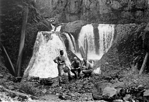
1963 photo of the expedition to name the waterfalls in the Salmon River Gorge
|
|
| Lua error in Module:Infobox_mapframe at line 185: attempt to index field 'wikibase' (a nil value). | |
| Location | Salmon–Huckleberry Wilderness |
| Coordinates | 45°14′48″N 121°53′49″W / 45.24667°N 121.89694°W |
| Type | Cascade |
| Elevation | 2,165 ft (660 m) |
| Total height | unconfirmed |
Frustration Falls is a beautiful waterfall with three distinct drops, located on the Salmon River in Clackamas County, Oregon. It sits at the edge of the amazing Mount Hood National Forest. This area is very special because the river creates many other cool waterfalls nearby.
The forest around the falls and river trail is filled with tall trees. You can see Douglas firs, western hemlocks, red cedars, bigleaf maples, red alders, and black cottonwood trees. It's a great place to explore nature!
Getting to Frustration Falls
To visit Frustration Falls, you can start your adventure on a hiking trail. This trail follows the Salmon River south from the town of Welches. Welches is located on U.S. Route 26 as it passes through the Mount Hood National Forest.
Trail Highlights
As you hike, you'll find several interesting spots along the way:
- Green Canyon Campground: This is the first landmark you'll reach. It has a restroom, which is handy!
- Wooden Bridge: After the campground, the trail crosses over the Salmon River on a sturdy wooden bridge.
- Rolling Riffle Campground: About two miles further, you'll find this historic campground nestled in the forest.
- Bighorn Campground: A mile past Rolling Riffle, you'll reach another campground.
- Final Falls: About half a mile after Bighorn Campground, you'll see Final Falls. Frustration Falls is just a bit further upstream from there.
The trail is about 7 mi (11 km) long, so it's a good hike! Remember to always follow safety rules when hiking near waterfalls.
 | Aurelia Browder |
 | Nannie Helen Burroughs |
 | Michelle Alexander |

