
Salmon River (Clackamas County, Oregon) facts for kids
Quick facts for kids Salmon River |
|
|---|---|

At Wildwood Recreation Site, less than 2 miles (3 km) from the river mouth
|
|

Mount Hood and vicinity showing the Salmon River (near the bottom center)
|
|
| Country | United States |
| State | Oregon |
| County | Clackamas County |
| Physical characteristics | |
| Main source | Mount Hood National Forest Mount Hood 6,124 ft (1,867 m) 45°20′09″N 121°42′24″W / 45.33583°N 121.70667°W |
| River mouth | Sandy River Brightwood 1,017 ft (310 m) 45°22′36″N 122°01′49″W / 45.37667°N 122.03028°W |
| Length | 33.5 mi (53.9 km) |
| Basin features | |
| Basin size | 115 sq mi (300 km2) |
| Type: | Wild, Scenic, Recreational |
| Designated: | October 28, 1988 |
The Salmon River is a 33.5-mile (53.9 km) long river in Oregon, a state in the United States. It flows through the Cascade Range and helps drain the southwestern part of Mount Hood. The entire river is special because it's protected as a National Wild and Scenic River. This means its natural beauty and wildlife are kept safe. Parts of the river also flow through protected wilderness areas. The Salmon River eventually flows into the Sandy River, which then joins the mighty Columbia River.
Contents
Journey of the Salmon River
The Salmon River starts high up on the south side of Mount Hood. Its path looks a bit like a curved blade, with the tip pointing towards Mount Hood and the handle pointing west.
Where the River Begins
The very beginning of the river, called its headwaters, is at the base of the Palmer Glacier on Mount Hood. It starts near Silcox Hut. The river then flows south for a few miles, staying east of Timberline Road. As it goes downhill, it turns southwest. It flows under Oregon Route 35 and then under U.S. Route 26.
Joining Other Streams
The West Fork Salmon River also starts near Timberline Lodge ski area. It flows south and gets water from cold natural springs. It also crosses under Highway 26. Soon after, the West Fork joins the main Salmon River. About a half-mile (1 km) later, the East Fork Salmon River flows in from a steep valley.
The combined river then flows south through Red Top Meadow and Salmon River Meadows. Here, it starts to wind and curve. Ghost Creek joins from the left, and then Mud Creek, which comes from Trillium Lake, joins from the right. Further downstream, Fir Tree Creek enters from the right as the river reaches the edge of the Salmon–Huckleberry Wilderness.
Through the Gorge and Waterfalls
The Salmon River then enters a deep, narrow gorge that runs east to west. Many smaller creeks flow into it here, like Wolf, Inch, Draw String, and Linney. The river turns northwest and flows over a series of six waterfalls in the next 3 miles (5 km). These waterfalls range from 15 to 75 feet (4.6 to 22.9 m) high. Some of the well-known ones are Stein, Split, Little Niagara, Vanishing, Frustration, and Final Falls. Near the Salmon River, Iron Creek also has its own waterfall called Hideaway Falls.


After Final Falls, Copper Creek and Bighorn Creek join the river. The river then leaves the wilderness area. About 1.5 miles (2.4 km) later, the South Fork Salmon River joins from the left. This South Fork drains a large area of mountains. From here, the river flows for 11 miles (18 km) on a flatter path, passing by Welches and Wemme.
It flows through the Wildwood Recreation Site near Wildwood. Finally, after crossing under Route 26 again, the Salmon River merges with the Sandy River near Brightwood. This meeting point is 37.5 miles (60.4 km) upstream from where the Sandy River joins the Columbia River.
Animals and Plants of the Salmon River
The areas around the lower parts of the Salmon River are home to many animals. You might find black bears, blacktail deer, cougars, badgers, fishers, and marten.
Trees and Plants
The forests here are very dense. You'll see tall western hemlock and Douglas-fir trees. Mixed in are western red cedar, red alder, and vine maple. A special and rare tree, the Alaska cedar, grows in small groups around the Salmon River Meadows.
Fish and River Life Cycle
The upper parts of the river are home to cutthroat trout. Downstream from the waterfalls, the river is a great place for fish to lay their eggs, a process called spawning. This is especially true for steelhead, Chinook salmon, and coho salmon. The river is actually named after these amazing salmon fish!
Fun Things to Do at the Salmon River
The Salmon River offers many outdoor activities, from exciting boating to peaceful camping and hiking.
Boating Adventures
People who love Whitewater boating sometimes go down a part of the lower river. This 5.5-mile (8.9 km) section has "fairly continuous class 2 rapids" and beautiful wilderness views. It starts at a bridge near a hiking trail and ends at the Arrah-Wanna Road bridge. This part of the river is rated as Class II+ to III, which means it's good for intermediate boaters. You need to watch out for logs and a section of boulders with a 3-foot (1 m) drop.
For expert kayakers, the Salmon River gorge further upstream is extremely challenging. Some call it the "Mount Everest of Oregon Kayaking." It has huge waterfalls that are very hard to get around, steep canyon walls, and difficult rescue possibilities. These gorge runs are rated Class V to V+, meaning they are for expert and extreme kayakers only.
Camping Spots
There are several great campgrounds near the Salmon River.
Alpine Campground
This campground is east of the Salmon River, close to Timberline Lodge. It's the highest campground in the Mount Hood National Forest. It has 16 sites for tents and offers access to hiking and mountain biking trails. You'll find picnic tables and drinking water here. It's open from early June to early September, but sometimes there's still snow in mid-summer!
Trillium Lake Campground
Located along Trillium Lake, west of the Salmon River, this campground has over 50 sites for tents and trailers. It's connected to Route 26 near Government Camp. It offers drinking water, picnic tables, toilets, and access to fishing, hiking, biking, and non-motorized boating on the lake.
Green Canyon Campground
About 4 miles (6 km) by road from Wemme, this campground is right along the Salmon River. It's open from late May to late September and has sites for tents and RVs. You'll find picnic tables and access to hiking trails and rainbow trout fishing. It has vault toilets but no drinking water.
Wildwood Recreation Site
This is a large 550-acre (220 ha) day-use area along the lower river. It's managed by the Bureau of Land Management. The site has many picnic tables, shelters, kitchens, playing fields, and courts. There's also a boardwalk over wetlands, an underwater viewing chamber, and an interpretive trail. You can also go fishing and swimming here.
Hiking Trails
The Salmon River area is perfect for hiking.
Salmon River Trail System
The Salmon River West Trailhead is a starting point for exploring the Salmon–Huckleberry Wilderness via the Salmon River Trail. This trail is 14 miles (23 km) long and generally follows a forested bluff above the north side of the river. At its eastern end, the Salmon River Trail connects to the famous Pacific Crest Trail using the 4.5-mile (7.2 km) long Jackpot Meadows Trail.
There are also other connecting trails, like the 2.1-mile (3.4 km) long Kinzel Lake Trail. These trails allow you to create many different hiking routes. This whole system of trails, known as the Salmon River National Recreation Trail, covers about 70 miles (110 km)! Downriver from the Salmon River West Trailhead, the Old Salmon River Trail goes for 2.5 miles (4.0 km) to the Old Salmon River Trailhead.
Images for kids
-
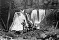
OGNB Members at Frustration Falls, Salmon River Gorge
-
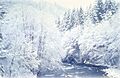
The Salmon River in winter
