Gabo Island facts for kids
| Geography | |
|---|---|
| Location | Bass Strait |
| Coordinates | 37°33′47″S 149°54′39″E / 37.5629167°S 149.9109722°E |
| Length | 2.4 km (1.49 mi) |
| Width | 0.8 km (0.5 mi) |
| Highest elevation | 52 m (171 ft) |
| Administration | |
|
Australia
|
|
| State | Victoria |
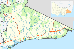
Gabo Island is a special island located off the coast of eastern Victoria, Australia. It covers about 154 hectares, which is like 380 football fields! The island sits between Mallacoota and Cape Howe, near the border with New South Wales.
A narrow channel, about 500 meters wide, separates Gabo Island from the mainland. You can reach the island by special flights or boats. Gabo Island is also important for weather warnings issued by the Australian Bureau of Meteorology, especially for ships in Bass Strait.
Gabo Island's Historic Lighthouse
Gabo Island is famous for its historic lighthouse. This lighthouse is Australia's second tallest. It was finished in 1862. The lighthouse was built using pink granite rocks found and cut right on the island.
The light from the lighthouse shines from 55 meters above sea level. It flashes three times every twenty seconds. A person called a caretaker lives in a house at the lighthouse. Another building there can be rented if you want to stay overnight.
Gabo Island's Weather and Climate
Gabo Island has its own unique weather patterns. The island's location influences its temperatures and rainfall throughout the year. Here's a look at the climate data for Gabo Island:
| Climate data for Gabo Island Lighthouse | |||||||||||||
|---|---|---|---|---|---|---|---|---|---|---|---|---|---|
| Month | Jan | Feb | Mar | Apr | May | Jun | Jul | Aug | Sep | Oct | Nov | Dec | Year |
| Record high °C (°F) | 40.8 (105.4) |
39.1 (102.4) |
38.6 (101.5) |
35.0 (95.0) |
26.6 (79.9) |
22.5 (72.5) |
23.3 (73.9) |
26.7 (80.1) |
31.0 (87.8) |
35.6 (96.1) |
37.2 (99.0) |
38.4 (101.1) |
40.8 (105.4) |
| Mean daily maximum °C (°F) | 21.3 (70.3) |
21.6 (70.9) |
21.0 (69.8) |
19.2 (66.6) |
16.9 (62.4) |
14.8 (58.6) |
14.1 (57.4) |
14.7 (58.5) |
15.9 (60.6) |
17.2 (63.0) |
18.4 (65.1) |
19.9 (67.8) |
17.9 (64.2) |
| Mean daily minimum °C (°F) | 15.8 (60.4) |
16.2 (61.2) |
15.4 (59.7) |
13.5 (56.3) |
11.2 (52.2) |
9.3 (48.7) |
8.2 (46.8) |
8.5 (47.3) |
9.7 (49.5) |
11.2 (52.2) |
12.8 (55.0) |
14.4 (57.9) |
12.2 (54.0) |
| Record low °C (°F) | 6.3 (43.3) |
7.8 (46.0) |
7.8 (46.0) |
6.4 (43.5) |
2.2 (36.0) |
3.3 (37.9) |
2.0 (35.6) |
2.8 (37.0) |
2.8 (37.0) |
2.8 (37.0) |
1.7 (35.1) |
7.2 (45.0) |
1.7 (35.1) |
| Average precipitation mm (inches) | 70.2 (2.76) |
67.7 (2.67) |
72.5 (2.85) |
84.4 (3.32) |
98.3 (3.87) |
103.4 (4.07) |
85.4 (3.36) |
71.5 (2.81) |
72.5 (2.85) |
74.4 (2.93) |
73.1 (2.88) |
66.7 (2.63) |
941.9 (37.08) |
| Average precipitation days | 9.4 | 9.1 | 10.6 | 11.8 | 13.4 | 14.4 | 13.7 | 13.3 | 13.3 | 13.3 | 11.6 | 10.8 | 144.7 |
| Source: Bureau of Meteorology | |||||||||||||
Amazing Birds of Gabo Island
Gabo Island is a very important place for birds. It is home to the world's largest colony of little penguins! Imagine up to 21,000 pairs of these cute birds living there.
BirdLife International has named Gabo Island and nearby Tullaberga Island an Important Bird Area. This is because of the huge numbers of breeding penguins and white-faced storm petrels (up to 20,000 pairs!). These birds come to the islands to lay their eggs and raise their young.
For a while, there was a problem with wild cats on the island. These cats were hunting the native birds and animals. So, between 1987 and 1991, a successful program removed the wild cats from the island. This helped protect the amazing bird life there.
 | Roy Wilkins |
 | John Lewis |
 | Linda Carol Brown |


