Gareloi Island facts for kids

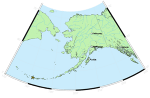
Gareloi (which is also called Gorely in Russian or Anangusix̂ in Aleut) is a volcanic island in Alaska. It is part of the Delarof Islands, which are a group of islands in the Aleutian Islands. This island is located between two ocean passages, the Tanaga Pass and the Amchitka Pass.
Contents
About Gareloi Island
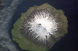
Gareloi Island is about 6 miles (10 km) long and 5 miles (8 km) wide. Its total land area is about 26 square miles (67 square km). This makes Gareloi the biggest island in the Delarof group. No one lives on Gareloi Island.
Gareloi Volcano
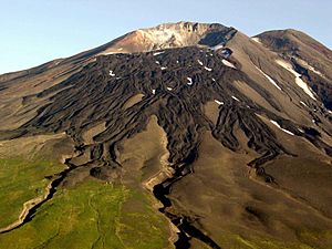
The main feature of the island is Gareloi Volcano, which is a type of volcano called a stratovolcano. This means it's a tall, cone-shaped volcano built up by many layers of hardened lava and ash. The volcano is in the middle of the island and reaches a height of 5,161 feet (1,573 meters). There is another peak on the island, but it is not as tall as the main volcano.
The island is mostly made of volcanic rocks like lava and ash. The lower parts of the island and its valleys are covered with grass and tundra, which is a type of flat, treeless land. The coasts have steep cliffs with big rocks at the bottom.
Home for Seabirds
The tall cliffs along the coast of Gareloi Island are a perfect home for many seabirds. More than 600,000 seabirds nest here! Most of these birds are small birds called auklets, who like to nest in cracks in the rocks.
- Least Auklets make up 62% of the birds.
- Crested Auklets make up 30%.
- Parakeet Auklets make up 6%.
A very large number of these birds live on Gareloi Island, showing how important this island is for their populations around the world.
Volcanic Activity
Gareloi's northern peak has a crater about 300 yards (274 meters) across. Inside this crater, there are active spots called fumaroles, which are openings that release steam and gases from the volcano.
Thirteen younger craters, ranging from 80 yards (73 meters) to 1 mile (1.6 km) wide, are lined up along a crack that goes from the shoreline to the southern peak. These craters formed during a big explosive eruption in 1929. That eruption also created four lava flows and covered an area of about 1.5 by 3 miles (2.4 by 4.8 km) on the volcano's southeast side with ash.
Recent Eruptions
Gareloi Volcano had four confirmed eruptions in the 1980s. Most of these were explosive eruptions, meaning they were powerful and threw out ash and rock. There was also one eruption in 1996 that was not officially confirmed.
In the spring and summer of 2007, the island experienced more earthquakes than usual. Sometimes there were as many as 40 earthquakes in a single day, which showed increased activity inside the volcano.
See also
 In Spanish: Isla Gareloi para niños
 | Tommie Smith |
 | Simone Manuel |
 | Shani Davis |
 | Simone Biles |
 | Alice Coachman |


