
Gareloi Volcano facts for kids
Quick facts for kids Gareloi Volcano |
|
|---|---|

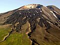
Summit of the volcano
|
|
| Highest point | |
| Elevation | 5,161 ft (1,573 m) |
| Prominence | 5,161 ft (1,573 m) |
| Listing |
|
| Geography | |

Gareloi
Location in Alaska
|
|
| Location | Gareloi Island, Alaska, U.S. |
| Parent range | Aleutian Islands |
| Geology | |
| Age of rock | Holocene-Pleistocene |
| Mountain type | Stratovolcano |
| Volcanic arc/belt | Aleutian Arc |
| Last eruption | August 1989 |
The Gareloi Volcano is a type of volcano called a stratovolcano. It's found in the Aleutian Islands of Alaska, United States. This volcano is about 1,259 miles (2,026 km) away from Anchorage.
Gareloi Volcano is located on Gareloi Island. It makes up most of the island's land. The island also has two small glaciers. These glaciers stick out towards the northwest and southeast.
The volcano's base is about 6 miles (10 km) by 5 miles (8 km) wide. It has two main tops, called summits. The southern crater is much bigger. It is 984 feet (300 m) wide and has fumaroles. Fumaroles are vents that release steam and gases. The northern crater of Gareloi is completely closed off.
Contents
Exploring Gareloi Volcano
Vitus Bering was a famous sailor from Russia. He went on many successful trips between 1725 and 1730. In 1740, Bering was sent to explore the area now known as the Bering Sea in the Pacific Ocean.
He set up a base on the Kamchatka Peninsula. There, he built two ships named St. Peter and St. Paul. In 1741, Bering and his crew sailed towards North America. A big storm stopped them and forced them to land. They couldn't see the Alaskan coast because of the storm. The storm was too strong, so the ships turned back. On their way, they mapped several of the Aleutian Islands, including Gareloi.
Since then, Gareloi Volcano has not been studied much. This means we don't know everything about its past eruptions. Some eruptions might not even be recorded.
Gareloi Island has no people living on it. It is part of the Alaska Maritime National Wildlife Refuge. The U.S. Fish and Wildlife Service manages this refuge.
How Gareloi Volcano Was Formed
Gareloi is the northernmost volcano in the Delarof Group. This group is a part of the Aleutian Islands. The volcano has two craters. The older crater is covered by lava flows. These flows run to the northwest and southern coasts.
The northern crater is small. It has a feature that suggests a dome collapsed on its northwest side. The southern side is higher up and much larger. It has active fumaroles releasing gases. A fissure, which is a long crack, was made by Gareloi's 1929 eruption. This crack runs along the southern summit of the volcano.

Steep sea cliffs on the southwest side of the island cut into an older caldera. A caldera is a large basin-shaped hollow. Three land masses near the island were formed by debris flows from the volcano.
Gareloi is made of lava flows and pyroclastic material. Pyroclastic material includes ash, rocks, and gas from an eruption. Two main events helped create the volcano. The lava deposits on the mountain are between 3 feet (1 m) and 20 feet (6 m) thick. Some of these flows came from outside vents on the volcano. This suggests that activity happened during the Pleistocene time period.
There are two large, u-shaped lava valleys on the island's southwest side. The oldest of these flows are from the Pleistocene age. They are made of basaltic trachyandesite and basaltic andesite. These rocks also contain smaller amounts of plagioclase, clinopyroxene, olivine, and hornblende.
The Rocks of Gareloi
The rocks that make up Gareloi Island and its volcano are thought to be from the Pleistocene age. This is because of the glaciers and landslide debris found there. The rocks are made of dissected lava flows and pyroclastic masses. They have been shaped by glaciers melting away. This process started about 10,000 years ago. Other landslides have also happened on the north and east sides of the volcano.
Mapping the Volcano
The Alaska Volcano Observatory mapped Gareloi Volcano in 2003. They also put in seismic monitors in June. These monitors help detect earthquakes and volcanic activity.
Volcano Eruptions
Gareloi has a long history of eruptions, going back to at least 1760. At least 12 eruptions have happened at the top of the volcano. These eruptions included lava and pyroclastic flows. Pyroclastic flows are fast-moving currents of hot gas and volcanic debris.
Typically, eruptions start from a central vent. Then, there is an explosive eruption. Sometimes, a phreatic explosion also occurs. A phreatic explosion happens when hot magma heats water, causing it to flash to steam. All these eruptions have been rated from 1 to 3 on the Volcanic Explosivity Index (VEI).
Eruptions have happened in:
- 1790, 1791, 1792
- 1873
- 1922, April 1929
- 1950, January 17, 1952
- August 7, 1980, January 15, 1982
- September 4, 1987, and August 17, 1989.
Some eruptions are uncertain, meaning they might have happened but aren't fully confirmed. These were in 1760, 1828, 1927, and 1996.
The 1929 Eruption
In 1929, Gareloi Volcano had a big explosive eruption. It created four lava flows. It also produced andesitic tuff, volcanic glass, and red scoria. Thirteen craters, all located in the fissure, contributed to this event. Most of these were likely phreatic eruptions.
During this eruption, pyroclastic flows mixed with tephra. Tephra is any material ejected from a volcano. Deposits suggest this happened. Lahars also flowed down from the summit. Lahars are dangerous mudflows made of volcanic ash and water.
Eruptions in the 1980s and 1990s
On August 8, 1980, Gareloi erupted for the first time since 1929. It sent ash plumes more than 35,000 feet (10,668 m) into the air. Small earthquakes happened on August 8 and 9. These quakes were west of the Adak seismic network.
A similar event happened in 1982. An ash cloud over 23,000 feet (7,010 m) high was seen in satellite images on January 15. The year 1987 was important in Gareloi's eruption history. A commercial airplane pilot saw a flow, likely from the volcano. This flow stretched for 1,312 feet (400 m) down the volcano. Steam was reported coming from the volcano. However, scientists couldn't confirm it was an eruption.
In 1989, an employee of the US Fish and Wildlife Service saw another ash plume. It covered the caldera and rose 2,300 feet (701 m) from the summit on August 17. A small eruption happened on September 27, 1996. It was reported to the National Weather Service in Anchorage. The plume, made of ash and steam, rose 5,000 feet (1,524 m) from the volcano's top.
Volcano Dangers
Volcanic dangers near Gareloi can be a big threat. If Gareloi erupts suddenly, ash clouds, falling volcanic ash, pyroclastic flows, and debris avalanches (like lahars) could cause deadly problems. These could even create tsunamis.
Volcanic ash can make airplane engines stop working. This puts commercial airplanes at high risk. Breathing in volcanic ash, also known as tephra, can cause breathing problems and eye irritation.
Pyroclastic flows from an eruption would destroy much of the wildlife around the volcano. Gareloi has produced several pyroclastic flows in the past. These flows can travel extremely fast. Future flows at Gareloi Volcano could travel off the island into the Pacific Ocean. If they are large enough, they could fall into the ocean and create tsunamis. However, this is not very likely.
Images for kids
-
Summit of the volcano
-
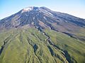
Fissure created from Gareloi's 1929 eruption. This feature runs down the southern summit.
See also
 In Spanish: Monte Gareloi para niños
