Gargantilla del Lozoya y Pinilla de Buitrago facts for kids
Quick facts for kids
Gargantilla del Lozoya y Pinilla de Buitrago
|
|||
|---|---|---|---|
|
|||

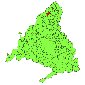
Municipal location within the Community of Madrid.
|
|||
| Country | |||
| Autonomous community | Community of Madrid | ||
| Area | |||
| • Land | 9.31 sq mi (24.12 km2) | ||
| Elevation | 3,717 ft (1,133 m) | ||
| Population
(2018)
|
|||
| • Total | 318 | ||
| Time zone | UTC+1 (CET) | ||
| • Summer (DST) | UTC+2 (CEST) | ||
Gargantilla del Lozoya y Pinilla de Buitrago is a small town, also called a municipality, located in the Community of Madrid, Spain. It has a very long name, in fact, it's known for having the longest official name for a municipality in all of Spain!
This special place is found in the beautiful region of the Community of Madrid. It's a quiet area, perfect for enjoying nature and learning about Spanish history.
Geography
Gargantilla del Lozoya y Pinilla de Buitrago is located in a lovely natural setting. It is surrounded by hills and valleys, which are typical of the Madrid region. The town is situated at an elevation of 1133 meters (about 3,717 feet) above sea level. This higher elevation often means cooler temperatures compared to lower areas.
Climate
The climate in Gargantilla del Lozoya y Pinilla de Buitrago is known as a Csb climate. This is according to the Köppen climate classification system.
What does Csb mean?
- The "C" means it's a temperate climate. This means it doesn't get extremely hot or extremely cold.
- The "s" means it has a dry summer. So, summers are usually sunny with little rain.
- The "b" means the summer is temperate, not too hot.
So, you can expect mild temperatures and dry, pleasant summers in this area. It's a great place to visit if you like comfortable weather!
See also
 In Spanish: Gargantilla del Lozoya y Pinilla de Buitrago para niños
 | Toni Morrison |
 | Barack Obama |
 | Martin Luther King Jr. |
 | Ralph Bunche |


