
Garners Beach Burial Ground facts for kids
Quick facts for kids Garners Beach Burial Ground |
|
|---|---|
.jpg)
Garners Beach Burial Ground, 2011
|
|
| Location | Garners Beach Road, Garners Beach, Cassowary Coast Region, Queensland, Australia |
| Design period | 1919 - 1930s (interwar period) |
| Built | 1935 - 1968 |
| Official name: Garners Beach Burial Ground, Clump Point Private Cemetery, Garners Beach Cemetery, Wilford Hill | |
| Type | state heritage (built) |
| Designated | 23 April 1999 |
| Reference no. | 601627 |
| Significant period | 1930s-1960s (fabric, historical use for burials) |
| Significant components | burial/grave, headstone, grave surrounds/railings |
| Lua error in Module:Location_map at line 420: attempt to index field 'wikibase' (a nil value). | |
Garners Beach Burial Ground is a special old cemetery located at Garners Beach in Queensland, Australia. It was built between 1935 and 1968. This site is also known as Clump Point Private Cemetery, Garners Beach Cemetery, and Wilford Hill. It was added to the Queensland Heritage Register on April 23, 1999, because of its historical importance.
History of Garners Beach
The Garners Beach Burial Ground is linked to the Garner family. They were among the first settlers in the Muff Creek area, which is just north of Mission Beach. The family owned land around Muff Creek from 1911 until the early 1970s.
The Garner Family Arrives
Edward Thomas Garner, his wife Edith Fay Johnson, and their three children moved to New South Wales around 1889. Edward Thomas (ET) Garner was a seaman who spent most of his life working on or building boats. He came to Queensland around 1889, bringing a boat to Townsville for the Hayles brothers. This boat helped them start their ferry service to Magnetic Island.
ET Garner stayed in North Queensland and began cutting timber. This work brought him to the Clump Point area, where he cut logs from the hills behind Mission Beach.
Settling and Working the Land
By 1900, the Garner family had settled in Cardwell. In the early 1900s, they used boats to carry supplies for Chinese farmers. These farmers were setting up banana plantations along the Hull River. The Garners also transported farm produce from the plantations to larger ships offshore.
In 1905, they started a sawmill on the Murray River. They made packing cases for the banana trade. In 1909, they moved to Bingil Bay. Here, ET Garner, his son Edward Henry (EH) Garner, and other family members built and managed a sawmill.
Starting a New Farm
In late 1910, ET Garner applied for his own piece of land. This land was about 160 acres along Muff Creek, with a coastline (now Garners Beach). It was covered in thick tropical jungle and forests. In December 1910, ET Garner was given a 20-year lease on this land, starting January 1, 1911.
On their Muff Creek farm, the ET Garners were joined by their son Edward Henry and daughter Elizabeth Ann Wildsoet. The Garner and Wildsoet families cleared the land and grew bananas to sell. Several shipping companies would pick up their produce from the beaches.
The Garners built several boats on their farm, some as long as 60 feet. They used these boats to carry settlers, goods, and farm produce along the creeks. They also helped with navigation lights in the area. When sugar farms started in the early 1910s, the Garners began making lime. They blasted coral from King Reefs, burned it at Garners Beach, and sold it to sugar cane farmers.
Life at Wilford Hill
By late 1915, over 40 acres of the Garner farm were being used for crops. They had 30 acres of bananas, 8 acres of citrus fruits, and 3 acres of pineapples. They also had 5 more acres cleared. Local Indigenous Australians helped with much of the work. They were paid with food and tools, which seemed to work well for everyone.
The family built four 4-room houses from silky oak with metal roofs. These houses were shipped from Townsville. The property was known as Wilford Hill, likely named after Wilford Hill in Nottingham, England, where ET and Edith Garner were married.
Challenges and Changes
During the World War I (1914-1918), only ET Garner, his wife, and youngest daughter Nellie stayed at the beach. Other family members left for war or other work. Shipping companies reduced their services, making it hard for settlers like the Garners to sell their produce.
A very strong cyclone in 1918 caused a lot of damage. It destroyed houses, farms, and boats. The ET Garners' house on Wilford Hill was swept away.
By the early 1920s, the Garners had returned to their farm. They had about 800 citrus trees and 12 acres of bananas. There was a 5-room house and five small huts on the property. These huts were built in the 1920s for family, visitors, and paying holiday-makers.
Helping Others During Hard Times
During the 1930s Great Depression, the huts served a kind purpose. A family member later recalled that people who were struggling were welcome to stay at Garners Beach. Since the area could produce most of its own food, no one went hungry. After a while, these people would move on, having been helped by the Garners.
In 1931, ET Garner's lease on the farm was extended. An inspection in 1931 noted it was a very well-kept farm with good improvements for dairy farming.
The First Burials
By mid-1935, Lou Wildsoet and his sons were managing the property. On August 24, 1935, Edith Garner, aged 67, passed away at Wilford Hill. She was buried the next day near her home. This was the first burial at what is now Garners Beach Burial Ground. ET Garner then moved to Tully. In 1937, his son EH Garner took over the lease and later gained full ownership of the land.
The second person buried at Garners Beach was Catherine Mary Garner, EH Garner's wife. She died on January 1, 1937, and was buried the next day. An old photo shows that a barbed wire fence once marked the burial ground.
Later Years and More Burials
By October 1939, EH Garner was mostly using Wilford Hill to raise a few dairy cattle. He spent most of his time running a boat for fishing trips to the Great Barrier Reef. During World War II (1939–45), several of EH Garner's children served in the armed forces. After the war, his sons returned and continued taking boating parties around the Reef.
ET Garner died on July 4, 1945, at the age of 86. He was buried the next day at the Clump Point Private Cemetery, which was the third burial there.
From 1951, the Garner family began to divide their land into smaller blocks. In the late 1950s and early 1960s, several holiday homes were built near Garners Beach. One of these was the holiday home of Harold Holt, who later became the Prime Minister of Australia. His home was close to the Garner graves.
In the 1960s, two more Garner family members were buried at Garners Beach. Edward Henry Garner died on March 27, 1965, and Edward Christian Garner died on August 18, 1968.
After EH Garner's death, about 26 acres of land, including the burial ground, went to his son Stanley Douglas Garner and his wife Elsie Norma Garner in 1965. They later sold the property, including the burial ground, to the Kenny family in 1972.
About the Burial Ground
Garners Beach is located in a large bay between Ninney Point and Murdering Point, a few kilometers north of Bingil Bay. The southeastern end of Garners Beach is where the Garner family first settled.
The burial ground is on private property, about halfway up a hill called Wilford Hill. This hill is at the southeastern end of Garners Beach. You can reach it from Garners Beach Road. The site is about 200 meters from where the early settlement was. It is a small area, about 12 by 13 meters, and is partly surrounded by vehicle tracks.
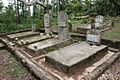
The Graves
The burial ground holds the graves of five members of the Garner family:
- Edith Fay Garner (buried August 25, 1935)
- Catherine Mary Garner (buried January 2, 1937)
- Thomas Edward Garner (buried July 5, 1945)
- Edward Henry Garner (buried March 29, 1965)
- Edward Christian Garner (buried August 20, 1968)
The graves are close together and face west. Four of the graves share a common concrete border. This border is about 250 mm high and 150 mm wide, and it used to have a simple metal fence around it. Edward Christian Garner's grave is just east of the others. It has its own concrete border with concrete corner posts and chains between them.
Each grave has a concrete headstone with a marble plaque. The headstones for the three men buried here have three symbols at the top: a ship's wheel, a Christian cross, and a ship's anchor. These symbols are carved into the stone and painted black.
Why It's a Heritage Site
Garners Beach Burial Ground was listed on the Queensland Heritage Register on April 23, 1999. This means it is considered an important historical place.
Showing Queensland's History
This burial ground helps us understand how Queensland's history unfolded. It shows the hard work of the Garner family, who were farmers, boat builders, and boat operators. They helped develop the Clump Point area into a fruit-producing region in the early 20th century.
Special Connection to People
The Garner family was well-known and respected in their local community. Their work in building and operating boats was very important to the development of the area. This site has a special connection to their lives and contributions to Queensland's history.
Images for kids
-
Garners Beach Burial Ground, 2011
