Gaube Lake facts for kids
Quick facts for kids Gaube Lake |
|
|---|---|

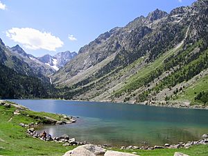
View of the lake in summer with Vignemale in the background
|
|
| Location | Hautes-Pyrénées |
| Coordinates | 42°49′52″N 0°08′23″W / 42.831138°N 0.139732°W |
| Lake type | Glacial lake |
| Primary inflows | Gaube River tributaries (Gave des oulettes de Gaube) |
| Primary outflows | Gaube River |
| Basin countries | France |
| Surface area | 0.19 km2 (0.073 sq mi) |
| Average depth | 40 m (130 ft) |
| Surface elevation | 1,725 m (5,659 ft) |
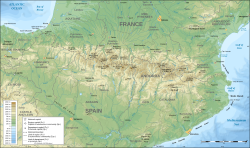
Gaube Lake is a beautiful lake located in the French Pyrenees mountains. You can find it in the Hautes-Pyrénées department, close to the town of Cauterets. In French, its name is Lac de Gaube.
Contents
What's in a Name?
The name "Gaube Lake" is a bit funny! In the old Gascon language, which people used to speak here, the word gaube actually means "lake." So, "Gaube Lake" literally means "Lake Lake"! It's like saying "River River."
Where is Gaube Lake Located?
Gaube Lake sits high up in the mountains, at an elevation of 1,725 meters (about 5,659 feet) above sea level. It has an oval shape, stretching from north to south in the Gaube valley. This valley has steep sides and is found right at the base of the huge Vignemale mountain, which is 3,298 meters (about 10,820 feet) tall.
The lake is surrounded by several other peaks:
- To the east, there's the Mayouret peak (2,688 m).
- To the southeast, you'll see the big Paloumères peak (2,720 m).
- To the northwest, there's the Gaube peak (2,377 m).
How Does the Lake Get and Lose Water?
The main water sources for Gaube Lake are small rivers that flow into it. These are called the Gaube River tributaries, or "Gave des oulettes de Gaube." The water then flows out of the lake through the Gaube River itself.
The lake is quite deep, averaging 40 meters (about 131 feet). Its surface covers about 19 hectares (or 0.19 square kilometers). The shoreline, which is the edge of the lake, stretches for more than 2 kilometers. At the point where the main river flows out, there's a small area of land built up by sand and rocks carried by glaciers.
What is the Lake's Geology Like?
The shores of Gaube Lake and the slopes around it are covered with different types of rocks. These rocks were shaped and moved by glaciers a very long time ago.
How Can You Visit Gaube Lake?
Gaube Lake is famous for its amazing views and how easy it is to reach. You can get there in a couple of ways:
- You can take about an hour-long hike through the forest.
- Or, you can ride a cable car from a place called Pont d'Espagne in the Cauterets valley.
The lake is also a popular starting point for many hiking trails. One famous trail, the GR 10, runs along the left side of the lake and leads towards the Gaube River tributaries.
See also
 In Spanish: Lago de Gaube para niños


