
Geodetic datum facts for kids
A geodetic datum is like a special starting point or a reference system that helps us accurately figure out where things are on Earth. Imagine you're trying to find a treasure on a map. You need a clear starting point and directions, right? A geodetic datum provides that starting point and framework for maps and GPS devices. It makes sure that when you use coordinates (like latitude and longitude), they point to the exact same spot for everyone.
Contents
What is a Geodetic Datum?
A geodetic datum is a set of carefully measured points and a mathematical model of the Earth's shape. Think of it as the foundation for all our maps and location services. Without a datum, different maps might show the same place in slightly different spots, which would be very confusing!
Why Do We Need Datums?
We need datums because the Earth isn't a perfect sphere. It's actually a bit squashed at the poles and bulges at the equator, like a slightly flattened ball. Scientists call this shape an ellipsoid or a geoid. A geodetic datum helps us deal with this uneven shape. It gives us a smooth, mathematical surface to use as a reference, making it easier to measure distances and locations precisely.
How Datums Help with Location
When you use a GPS on your phone or in a car, it relies on a geodetic datum. The GPS device receives signals from satellites and uses the datum to calculate your exact position on Earth. This is super important for things like:
- Navigation: Helping planes, ships, and cars find their way.
- Mapping: Creating accurate maps for cities, countries, and even the whole world.
- Construction: Making sure buildings, bridges, and roads are built in the right place.
- Science: Tracking changes in the Earth's crust or sea levels.
Types of Geodetic Datums
There are two main types of geodetic datums:
- Horizontal Datums: These are used to measure positions (like latitude and longitude) on the Earth's surface. They help us know exactly where something is located horizontally.
- Vertical Datums: These are used to measure heights or depths. They tell us how high a mountain is or how deep the ocean is, usually measured from a specific "sea level" reference point.
Global vs. Local Datums
Some datums are global, meaning they are designed to work all over the world. The most famous global datum is the World Geodetic System 1984, often called WGS84. This is the datum used by most GPS devices today.
Other datums are local. These are designed to be very accurate for a specific area, like a country or a region. For example, the United States uses a datum called the North American Datum of 1983 (NAD83) for many of its maps. Local datums might be slightly different from global ones because they are optimized for their specific area.
How Datums Are Created
Creating a geodetic datum involves a lot of careful measurement and calculation.
- Early Surveys: In the past, scientists and surveyors used triangulation. They would measure angles and distances between points on the ground, often from high places like mountains. One of the first big surveys was The Great Trigonometrical Survey of India, which started in 1802. It took many years to complete and helped map a huge part of the world.
- Satellite Technology: Today, we use advanced technology like GPS and satellite geodesy. Satellites orbiting Earth send signals that help us measure distances and positions with incredible accuracy. This allows us to create very precise global datums like WGS84.
Importance in Everyday Life
Even if you don't realize it, geodetic datums affect your daily life. Every time you use a navigation app to find a restaurant, or look at a map to plan a trip, you're relying on a geodetic datum to make sure the information is correct. They are the invisible backbone of our modern world of location-based services.
Images for kids
-
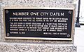
City of Chicago Datum Benchmark
-
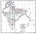
The Great Trigonometrical Survey of India, one of the first surveys comprehensive enough to establish a geodetic datum.


See also
 In Spanish: Datum para niños
