Geology of the Tasman District facts for kids
The Tasman Region and the nearby Nelson Region are super interesting places in New Zealand if you like rocks! They have some of the oldest rocks found on New Zealand's main islands. These areas also contain all the main types of "terranes" that make up New Zealand's deep foundation, called the "basement."
These basement rocks include special kinds of rocks called Ultramafic rocks, like Serpentine and Dunite. You can also find valuable minerals here, such as shiny Gold! The Nelson Region is next to a huge crack in the Earth's crust called the Alpine Fault. This fault is where two giant land plates, the Pacific Plate and the Indo-Australian Plate, meet. This movement helped create the amazing Southern Alps.
Contents
New Zealand's Foundation Rocks: Terranes
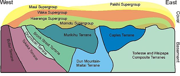
New Zealand's deep foundation, or "basement," is made of different sections called terranes. Think of them like giant puzzle pieces that came together over millions of years. Geologists divide these terranes into two main groups: the Western Province and the Eastern Province.
The Western Province includes the Buller and Takaka terranes. The Eastern Province has many more, like the Brook Street, Murihiku, Dun Mountain-Maitai, Caples, Torlesse Composite, and Waipapa Composite Terranes. A large block of rock called the Median Batholith sits between these two main provinces. Guess what? All these different terranes can be found in or very close to the Nelson Region!
Western Province Terranes
The Buller Terrane forms the bedrock west of the Anatoki Fault. This area stretches from Whanganui Inlet down to Springs Junction. You can also find it along the West Coast, west of the Alpine Fault, all the way to Milford Sound. The oldest rocks here are from the Greenland Group. They are sandstones and mudstones that formed on the ocean floor between 505 and 470 million years ago. On top of these are the Golden Bay Group rocks, which are quartz sandstone and shale, formed between 490 and 443 million years ago.
The Takaka Terrane is found east of the Anatoki Fault. It covers areas like Takaka, the Arthur and Matiri Ranges, and goes south to Springs Junction. This terrane is very complex and has many cracks, or "faults." The oldest rocks in New Zealand's main islands are found here! They formed in an ocean where volcanoes were active, about 518-515 million years ago. In the Cobb Valley, you can see rocks like gabbro and ultramafic rocks, which have mostly changed into serpentine. Later rocks, formed between 500 and 397 million years ago, include the famous Mount Arthur limestone and marble.
Scientists believe the Buller and Takaka Terranes joined together about 390 million years ago. After they joined, around 370-354 million years ago, special pink granite rocks called the Karamea Suite pushed their way into the Buller Terrane. This pink color comes from large pink crystals inside the granite.
The Median Batholith
The Median Batholith is a huge block of rock that separates the Western and Eastern Provinces. It's thought to be a very old and long-lasting "batholith," which is a large mass of igneous rock formed deep underground. It was created by a "subduction zone" (where one plate slides under another) along the edge of eastern Australia, before the Tasman Sea even existed! This happened between 375 and 110 million years ago.
Parts of the Median Batholith include the Riwaka Complex (around 375 million years old) and the Separation Point Suite (around 110 million years old). The Riwaka Complex rocks are found west of Abel Tasman National Park. The Separation Point Suite forms the granite rocks from Abel Tasman National Park south to Springs Junction. Even though much of the Median Batholith is hidden under the Moutere Depression, you can see it in places like Peppin Island near Nelson City and around Nelson Lakes.
Eastern Province Terranes
The Brook Street, Murihiku, and Dun Mountain-Maitai Central Arc Terranes are found in narrow strips to the east of the Waimea-Flaxmore Fault System. They stretch from Durville Island in the north down to the Alpine Fault near Nelson Lakes in the south.
The Brook Street Terrane formed about 300-250 million years ago from an oceanic island arc (a chain of volcanic islands). It has well-preserved parts of old volcanic cones.
The Murihiku Terrane is made of marine sandstone that formed between 250 and 145 million years ago. These rocks came from a volcanic arc and haven't been changed much.
The Dun Mountain-Maitai Terrane includes the Dun Mountain Ophiolite Belt, which is about 290-256 million years old. This belt is made of dark, heavy rocks from the ancient seafloor and deep inside the Earth. Because these rocks have high levels of nickel and magnesium, it's hard for plants to grow on Dun Mountain and Red Hills. On top of these rocks are the Maitai Group rocks, which are breccia, sandstone, siltstone, and limestone, formed between 290 and 206 million years ago.
The Caples Terrane makes up a lot of the Marlborough Sounds. It stretches from east of D'Urville Island to west of Charlotte Sound, and southwest to Nelson Lakes and the Alpine Fault. The Caples Terrane formed between 256 and 227 million years ago. Its rocks are mostly sandstone and argillite (a type of mudstone). They were laid down by underwater currents next to an island arc. Some of these rocks have changed into schist near the Rakaia Terrane.
The Torlesse (Composite) Terrane is made up of the Rakaia and Pahau Terranes. These rocks are mostly marine sandstone and mudstone. The Pahau Terrane (159-99 million years old) is younger than the Rakaia Terrane (290-206 million years old). Some schist rocks south of the Caples Terrane and north of the Alpine Fault are part of the Rakaia Terrane. Rocks south of the Alpine Fault also belong to the Torlesse Composite Terrane.
The Waipapa (Composite) Terrane includes the Hunua and Morrinsville Terranes. The rocks around Picton and Arapawa Island are thought to be part of the Morrinsville Terrane. These are sandstone rocks from about 227-206 million years ago that have changed into schist.
Interestingly, the rocks in western Nelson used to be right next to the rocks in Fiordland and Central Otago. They moved apart when the Alpine Fault became active about 23 million years ago. The types of terranes in Nelson match those on the other side of the Alpine Fault!
Coal and Limestone Deposits
Most of the Nelson area was above sea level from the Late Cretaceous to the Middle Eocene periods. During the Late Cretaceous, swamps formed around the Whanganui Inlet, and this is where coal began to develop. Later, these coal layers were covered by sandstone and then by conglomerate (a rock made of pebbles). Much of these covering rocks have since worn away.
More coal also formed in swamps across western Nelson during the Late Eocene (40-34 million years ago). You can still find these coal deposits in places like the Buller Coalfield, Heaphy River, Takaka, and Richmond. After this, the land slowly sank, and the sea moved in. This led to the formation of calcareous sandstone, mudstone, and limestone during the Oligocene period (34-24 million years ago).
Uplift and Mountain Building
The powerful Alpine Fault started moving about 23 million years ago. This movement caused the land to lift up, and the types of rocks being deposited changed from limestone to mudstone. A big period of rapid uplift, which created the Southern Alps, happened much later, about 3 million years ago. This rapid uplift created huge amounts of gravel from the Torlesse rocks, which can be seen in the Moutere Depression.
How the Land is Moving Today
The Alpine Fault is still moving, shifting about 3-5 millimeters each year. The Awatere Fault is even faster, moving 6-8 millimeters per year. The Waimea-Flaxmore Fault System is also active. In the Marlborough Sounds, the land is slowly sinking by 1-7 millimeters each year. However, Nelson itself is quite stable, and the western coast is actually rising very slowly, about 0-1 millimeter per year.
Valuable Earth Resources
People have found alluvial gold (gold washed into rivers) in the Anatoki, Takaka, Aorere, and Paparoa valleys of Golden Bay. Gold has also been mined from specific areas like the Aorangi Mine and Johnston's United Mine. You can also find it in the Caples Terrane schist.
Chromium and copper have been mined from the Dun Mountain Ophiolite Belt.
Asbestos, talc, and magnesite have been mined in the Cobb area.
Coal has been mined in many places, including Collingwood, Takaka, Nelson-Richmond, Baton, Heaphy, Karamea, and the Buller areas.
The beautiful Mount Arthur marble is used in buildings. Also, younger limestone is quarried to make cement.
Scientists believe the sea northwest of the Nelson region might have potential for oil and gas deposits.
Earthquake Risks
The main natural danger in this region comes from earthquakes. These can happen along the Alpine Fault or other related faults. Earthquakes in nearby areas like Murchison, Kaikoura, and Wellington could also cause damage in the Nelson and Tasman regions.
Cool Geological Places to Visit
- The Cobb Valley is a fascinating place to see mafic and ultramafic rocks, serpentine, talc, and asbestos.
- Abel Tasman National Park is great for seeing limestone and marble, the Separation Point granite, and the Riwaka Complex diorite and gabbro. From the top of the park, you can even see Harwoods Hole, a huge vertical shaft that leads down to the limestone cave system of Takaka Hill.
- The Arthur Range is a perfect spot to see the famous Mount Arthur marble.
- The Bryant Range offers a good view of the Central Arc Terranes.
- Red Hill and Dun Mountain are excellent places to observe how ultramafic rocks affect what plants can grow.
- Taking a trip on the inter-island ferry gives you a wonderful view of the Marlborough Sounds.
- You can see the mighty Alpine Fault in the Wairau Valley, between Blenheim and Nelson Lakes.
- The effects of ancient glaciers can be seen around Nelson Lakes.
Geological Maps
You can get geological maps of New Zealand from the New Zealand Institute of Geological and Nuclear Science (GNS Science). This is a government research institute.
GNS Science also provides a free online Map of New Zealand's Geological Foundations.
Their main maps are the 1:250,000 QMap series. These maps come with booklets and were mostly completed by 2010. You can download lower-quality versions of these maps for free from the GNS website.
- The map for the Nelson Area was released in 1998.
- The map for the Wellington Area was released in 2000.
- The map for the Greymouth Area was released in 2002.
- The map for the Kaikoura Area was released in 2006.
 | Ernest Everett Just |
 | Mary Jackson |
 | Emmett Chappelle |
 | Marie Maynard Daly |


