Mount Arthur (New Zealand) facts for kids
Quick facts for kids Mount Arthur |
|
|---|---|

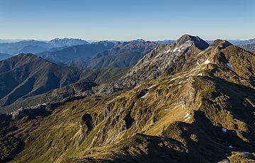
Wharepapa / Arthur Range, taken from the track leading to the summit
|
|
| Highest point | |
| Elevation | 1,795 m (5,889 ft) |
| Listing | Mountains of New Zealand |
| Naming | |
| Native name | Error {{native name}}: an IETF language tag as parameter {{{1}}} is required (help) |
| Geography | |
| Country | New Zealand |
| District | Buller |
| Parent range | Wharepapa / Arthur Range |
| Protected area | Kahurangi National Park |
Mount Arthur, known as Tuao Wharepapa in Māori, is a tall mountain in the South Island of New Zealand. It is part of the Wharepapa / Arthur Range in the northwest. This mountain stands 1,795 meters (about 5,889 feet) high. Mount Arthur was named after Captain Arthur Wakefield. It is located inside Kahurangi National Park, a large protected area.
Understanding Mount Arthur's Rocks
Mount Arthur is mostly made of a very hard rock called marble. This marble was once limestone, a softer rock. It changed into marble under great heat and pressure deep underground. This change happened about 450 million years ago. Back then, the limestone formed at the bottom of the sea.
The marble found here is called "Arthur Marble." It is part of a larger rock area known as the Takaka Terrane. This land was once part of a huge ancient continent called Gondwana. The rocks here are similar to those found in parts of modern-day Australia.
Amazing Caves Underground
Below Mount Arthur, there are many deep and complex cave systems. Explorers are still finding new parts of these caves today. The mountain is home to the Ellis Basin cave system. This is the deepest cave system in the Southern Hemisphere. Before it was discovered in 2010, Nettlebed Cave was thought to be the deepest.
How Glaciers Shaped the Mountain
During the ice ages, small glaciers moved across Mount Arthur. These glaciers carved out smooth, bowl-shaped areas high on the mountain. These areas are called 'cirques'. The glaciers polished and scraped the tough marble rock. The bottoms of these cirques have many sinkholes. These sinkholes are where surface water flows underground. This water then enters the mountain's large cave systems.
 | Isaac Myers |
 | D. Hamilton Jackson |
 | A. Philip Randolph |


