Gesse facts for kids
Quick facts for kids Gesse |
|
|---|---|
 |
|
| Country | France |
| Physical characteristics | |
| Main source | Arné 550 m (1,800 ft) 43°09′17″N 00°28′00″E / 43.15472°N 0.46667°E |
| River mouth | Save 175 m (574 ft) 43°26′04″N 00°51′06″E / 43.43444°N 0.85167°E |
| Length | 52.1 km (32.4 mi) |
| Basin features | |
| Progression | Save→ Garonne→ Atlantic Ocean |
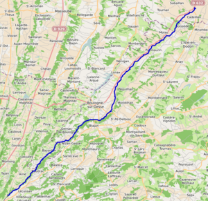
The Gesse is a river in southwestern France. It is about 52.1 km (32.4 mi) long. The Gesse flows through three different areas of France called départements. These are the Hautes-Pyrénées, Haute-Garonne, and Gers.
The river starts at a place called Arné. This is on a flat area known as the plateau de Lannemezan. The Gesse generally flows towards the northeast. It is a left tributary, meaning it joins another river from the left side. The Gesse flows into the Save river at a town called Espaon.
Journey of the Gesse River
The Gesse river starts its journey in the Hautes-Pyrénées area. It then flows through many towns and villages. As it travels, it passes through the Haute-Garonne and Gers départements.
Towns Along the Gesse
The Gesse river flows past several towns. Here are some of the main ones it goes through, from where it starts to where it ends:
- In Hautes-Pyrénées: Arné
- In Haute-Garonne: Boudrac, Saint-Loup-en-Comminges, Nizan-Gesse, Gensac-de-Boulogne, Blajan, Boulogne-sur-Gesse, Péguilhan, Lunax, Nénigan, Saint-Ferréol-de-Comminges, Puymaurin, Molas, Boissède
- In Gers: Tournan, Cadeillan, Sabaillan, Sauveterre, Espaon
See also

- In Spanish: Gesse para niños
 | Audre Lorde |
 | John Berry Meachum |
 | Ferdinand Lee Barnett |

