
Giddings Road Covered Bridge facts for kids
Quick facts for kids Giddings Road Bridge |
|
|---|---|
_Covered_Bridge_1.jpg) |
|
| Coordinates | 41°45′53″N 80°43′57″W / 41.76472°N 80.73250°W |
| Locale | Ashtabula County, Ohio, United States |
| Characteristics | |
| Design | single span, Pratt truss |
| Total length | 107 feet (32.6 m) |
| History | |
| Construction begin | 1995 |

|
|

The Giddings Road Bridge is a special type of bridge called a covered bridge. It crosses over Mill Creek in Jefferson Township, which is in Ashtabula County, Ohio, United States. This bridge is one of 16 covered bridges you can still drive across in Ashtabula County!
The bridge has a single span, meaning it crosses the water in one long section. It uses a design called a Pratt truss, which is a way to arrange the beams to make the bridge super strong. It was built with special funding from a grant, helping to preserve this classic style of bridge. You can find the bridge about 2.7 miles (4.3 km) northeast of Jefferson.
Bridge History
The Giddings Road Bridge was built in 1995. It was a new addition to Ashtabula County's collection of historic covered bridges.
Bridge Size
The Giddings Road Bridge is 107 feet (32.6 meters) long. That's about the length of three school buses lined up end-to-end!
Bridge Pictures
-
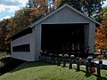
This picture shows the north side of the bridge.
-
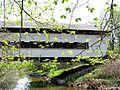
A view of the bridge in May 2015.
-
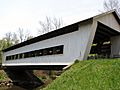
Another angle of the bridge.
-
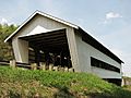
The bridge from a different perspective.
_Covered_Bridge_2.jpg)

.jpg)
.jpg)
