Glen Hall, Indiana facts for kids
Quick facts for kids
Glen Hall, Indiana
|
|
|---|---|

Looking north into Glen Hall along County Road 700W
|
|

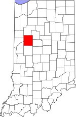
Tippecanoe County's location in Indiana
|
|
| Country | United States |
| State | Indiana |
| County | Tippecanoe |
| Township | Wayne |
| Elevation | 617 ft (188 m) |
| Time zone | UTC-5 (Eastern (EST)) |
| • Summer (DST) | UTC-4 (EDT) |
| ZIP code |
47992
|
| Area code(s) | 765 |
| GNIS feature ID | 435116 |
Glen Hall, sometimes called Glenhall, is a small place in Indiana, United States. It is an "unincorporated community." This means it does not have its own local government like a city or town. Instead, it is part of Wayne Township in Tippecanoe County. People often think of Glen Hall as part of the nearby town of West Point.
Contents
History of Glen Hall
Early Services in the Community
A long time ago, in 1866, Glen Hall had its own post office. This was a very important place where people could send and receive letters and packages. The post office stayed open for many years, helping the community connect with the outside world. However, it eventually closed down in 1904.
Geography of Glen Hall
Where is Glen Hall Located?
Glen Hall is located very close to the town of West Point. It is less than half a mile (about 0.8 kilometers) north of West Point. This small community is part of Wayne Township.
Elevation of the Area
The land where Glen Hall sits is about 625 feet (which is about 190 meters) above sea level. This measurement tells us how high the ground is compared to the ocean.
 | Jackie Robinson |
 | Jack Johnson |
 | Althea Gibson |
 | Arthur Ashe |
 | Muhammad Ali |


