
Glenmore Bay facts for kids
Quick facts for kids Glenmore Bay |
|
|---|---|

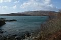
Glenmore Bay, Loch Sunart. From the road near Glenborrodale.
|
|

Glenmore Bay
Location in Lochaber
|
|
| Location | Loch Sunart Ardnamurchan, Scotland |
| Coordinates | 56°41′2.040″N 5°56′10.344″W / 56.68390000°N 5.93620667°W |
| River sources | Glenmore River |
| Ocean/sea sources | Atlantic Ocean |
| Basin countries | Scotland |
| Max. length | 0.72 km (0.45 mi) |
| Max. width | 0.6 km (0.37 mi) |
| Islands | Eilean Mòr |
| Settlements | Glenmore |
Glenmore Bay is a quiet, beautiful bay in Scotland. It's on the southern coast of the Ardnamurchan peninsula, right at the end of a sea loch called Loch Sunart. A "sea loch" is like a narrow arm of the sea that reaches inland. The bay is affected by tides, meaning the water level goes up and down each day.
Exploring Glenmore Bay
Glenmore Bay has a small village right by the water. Here, you can find the Ardnamurchan Natural History and Visitor Centre. This center is a popular spot for tourists. It's a great place to learn about the local wildlife and history.
Just a little to the east of the main village is an even tinier place called Glenbeg. To reach Glenmore Bay, you'll travel on a small, single-lane road called the B8007. This road has special spots for cars to pass each other. It connects to a bigger road, the A861, about 9 miles (14.5 km) to the east in a village called Salen. As you drive along this road, you'll pass through other small villages like Glenborrodale and Laga. The journey offers lovely views of Loch Sunart.
The Geography of Glenmore Bay
Glenmore Bay is one of four bays found along a 2.78 km stretch of coastline. These bays are bordered by the large Glenborrodale nature reserve to the east. To the west, you'll find the Ardslignish peninsula.
Glenmore Bay is the most eastern of these four bays. As you move west, you'll find Port na Croisg, then Camas Fearna, and finally the small bay of Camas Bàn. Glenmore Bay is separated from Port na Croisg by a place called Eilean Mòr. Sometimes, Eilean Mòr is an island, and other times it's connected to the mainland by a small strip of land.
Because Glenmore Bay is tidal, its shoreline changes with the water level. The land where it meets the bay is covered in special sand and sea-grasses. This type of land is called machair.
Gallery
-
Glenmore Bay, Loch Sunart
-
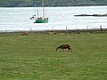
Deer, Cattle and Boats At Glenmore Bay.


