Ardnamurchan facts for kids
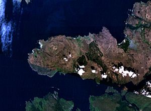
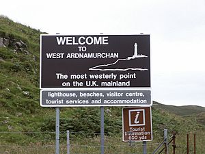
Ardnamurchan (Scottish Gaelic: Àird nam Murchan: headland of the great seas) is a 50-square-mile (130-square-kilometre) peninsula in Lochaber, Highland, Scotland. It is famous for being very wild and untouched. Getting there can be tricky. The main road is mostly a single track road. The most westerly point of mainland Great Britain, Corrachadh Mòr, is found here.
From 1930 to 1975, Ardnamurchan was also the name for a larger area. This area included places like Morvern, Sunart, and Ardgour.
Contents
Exploring Ardnamurchan's Geography
Strictly speaking, Ardnamurchan is the land beyond Salen (in the south) and Acharacle (in the north). But today, the name often includes nearby areas. These are Sunart, Ardgour, Morvern, and even Moidart.
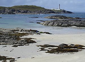
Ardnamurchan Point is a famous spot. It has the 36-metre-tall (118 ft) Ardnamurchan Lighthouse. Many people think this is the most westerly point of the British mainland. However, Corrachadh Mòr, about a kilometer south, is actually a few meters further west.
Understanding Ardnamurchan's Geology
The northwest part of Ardnamurchan has a special rock formation. It's called a lopolith. This is a large, bowl-shaped rock body. It was formed deep underground by magma. Over time, the land above it wore away. This exposed the lopolith at the surface.
You can see the circular patterns of this rock structure. They are clear in satellite photos and on maps. These patterns are less obvious when you are on the ground. There are other similar rock formations in western Britain. Geologists often visit these sites to study them.
A Glimpse into Ardnamurchan's History
Adomnan of Iona wrote about St Columba visiting Ardnamurchan. This was in the 6th century. Adomnan's writings suggest that Irish Gaels lived there then. He recorded three amazing stories about Columba on the peninsula.
In one story, Columba predicted the death of two kings. News of their deaths arrived later that same day. This happened at a place called 'paradise bay'. In another story, a boy's parents brought him to Columba for baptism. There was no water. Columba prayed, and water appeared from a rock. He also predicted the boy's future life.
The third story took place at 'Sharp bay'. A bad man named Ioan stole from Columba's friend. Columba told him to change his ways. But Ioan got on his boat with the stolen goods. Columba waded into the water and prayed. He then said the man and his boat would face disaster. Adomnan wrote that the boat sank, and Ioan drowned with the stolen items.
The village of Bourblaige no longer exists. It was destroyed in the Highland Clearances in the early 1800s. Its stone foundations can still be seen.
Archaeological finds suggest battles happened here. Spears, daggers, and arrowheads have been found. A coin from the time of King Edward I was also discovered. These items might be from conflicts in the 13th century.
In 2011, a Viking ship burial was found at Port an Eilean Mhòir. It was likely from the 10th century. Inside, archaeologists found a Viking warrior. The items buried with him suggest he was important. These included an axe, a decorated sword, a spear, and a shield. Other finds were a knife, a bronze drinking horn tip, a whetstone from Norway, and a ring pin from Ireland.
Ardnamurchan's Settlements
About 2000 people live on the peninsula. Ardnamurchan was once part of the Argyll county. Now, it is part of the Lochaber area in the Highland local authority.
Here are some villages in Ardnamurchan:
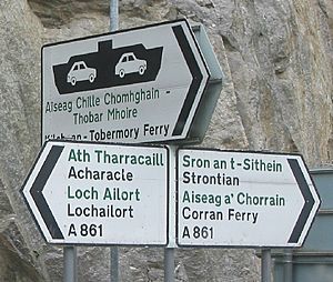
- Acharacle (Àth Tharracail)
- Achnaha (Achadh na h-Àtha)
- Glenborrodale (Gleann Bhorghdail)
- Kilchoan (Cille Chòmhghain)
- Kilmory (Cill Mhóire)
- Laga (Làga)
- Ockle (Ocal)
- Portuairk (Port Uairce)
- Salen (An t-Sàilean)
- Sanna (Sanna)
Scottish Gaelic Language in Ardnamurchan
Ardnamurchan has many Gaelic speakers. About 19.3% of people here can speak the language. This is one of the highest numbers on the Scottish mainland.
The peninsula has also been home to local Gaelic poets. Dr John MacLachlan wrote a famous poem. It was about the Ardnamurchan Clearances. This poem was special because it openly criticized the landlords.
Ardnamurchan's Culture
Ardnamurchan has its own shinty team. They are called Ardnamurchan Camanachd. Shinty is a traditional Scottish sport. It is similar to hockey.
Wildlife and Scenery in Ardnamurchan
Ardnamurchan is a wild and beautiful place. You might see rare animals here. These include the wildcat, pine marten, golden eagle, and white-tailed eagle.
Ardnamurchan Point offers amazing views. From its high cliffs, you can see the wide Atlantic Ocean. The northern part of Ardnamurchan is part of a National Scenic Area. These areas are protected because of their outstanding natural beauty.
Famous People from Ardnamurchan
- The geologist Donald Duff (1927–98) bought a house here. He had surveyed the area in the 1950s.
- The button box accordion player, Fergie MacDonald, is from this area.
- The preacher J. Douglas MacMillan also came from Ardnamurchan.
See also
 In Spanish: Ardnamurchan para niños
 | Anna J. Cooper |
 | Mary McLeod Bethune |
 | Lillie Mae Bradford |


