Glenwood, Georgia facts for kids
Quick facts for kids
Glenwood, Georgia
|
|
|---|---|

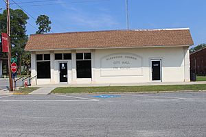
City Hall in Glenwood
|
|

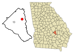
Location in Wheeler County and the state of Georgia
|
|
| Country | United States |
| State | Georgia |
| County | Wheeler |
| Area | |
| • Total | 1.89 sq mi (4.89 km2) |
| • Land | 1.86 sq mi (4.82 km2) |
| • Water | 0.03 sq mi (0.06 km2) |
| Elevation | 194 ft (59 m) |
| Population
(2020)
|
|
| • Total | 850 |
| • Density | 456.50/sq mi (176.28/km2) |
| Time zone | UTC-5 (Eastern (EST)) |
| • Summer (DST) | UTC-4 (EDT) |
| ZIP code |
30428
|
| Area code(s) | 912 |
| FIPS code | 13-33392 |
| GNIS feature ID | 0314643 |
Glenwood is a small city located in Wheeler County, Georgia, in the United States. It is a quiet place where people live and work. In 2020, about 850 people called Glenwood home.
Contents
Where is Glenwood Located?
Glenwood is found at specific coordinates: 32 degrees, 10 minutes, 52 seconds North and 82 degrees, 40 minutes, 22 seconds West. This helps pinpoint its exact spot on a map.
Land Area of the City
According to the United States Census Bureau, Glenwood covers a total area of about 3.2 square miles (which is about 4.89 square kilometers). All of this area is land, meaning there are no large lakes or rivers within the city limits.
How Many People Live in Glenwood?
The number of people living in Glenwood has changed over the years. This information comes from the United States Census Bureau, which counts people every ten years.
| Historical population | |||
|---|---|---|---|
| Census | Pop. | %± | |
| 1910 | 347 | — | |
| 1920 | 592 | 70.6% | |
| 1930 | 569 | −3.9% | |
| 1940 | 625 | 9.8% | |
| 1950 | 684 | 9.4% | |
| 1960 | 682 | −0.3% | |
| 1970 | 670 | −1.8% | |
| 1980 | 824 | 23.0% | |
| 1990 | 881 | 6.9% | |
| 2000 | 884 | 0.3% | |
| 2010 | 747 | −15.5% | |
| 2020 | 850 | 13.8% | |
| U.S. Decennial Census | |||
In the year 2000, there were 884 people living in Glenwood. These people made up 354 households, with 210 of those being families. By 2020, the population of Glenwood had slightly decreased to 850 people.
See also

- In Spanish: Glenwood (Georgia) para niños
 | William L. Dawson |
 | W. E. B. Du Bois |
 | Harry Belafonte |

