Godrevy facts for kids
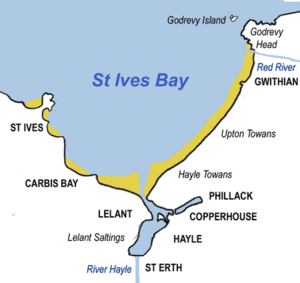
Godrevy (which means small farms in Cornish) is a beautiful area in west Cornwall, England. It's on the eastern side of St Ives Bay and faces the huge Atlantic Ocean. Godrevy is a super popular spot for both surfing and walking.
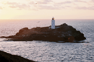
A big part of Godrevy is owned by the National Trust, a charity that protects special places. Just offshore, on Godrevy Island, stands a lighthouse looked after by Trinity House. People say this lighthouse was the inspiration for the famous book To the Lighthouse by Virginia Woolf. Godrevy is also part of the Cornwall Area of Outstanding Natural Beauty (AONB), which means it's a specially protected landscape. The South West Coast Path, a long walking trail, goes all around this area. You can find public car parks and a café run by the National Trust on the western side.
Contents
Godrevy Head: A Special Place
Godrevy Head is a piece of land that sticks out into the Atlantic Ocean in Cornwall. It's on the eastern side of St Ives Bay, about 5 kilometers (3 miles) northeast of Hayle. The closest village is Gwithian, just half a mile west.
This headland is roughly square-shaped and covers about 1 square kilometer (0.4 square miles). In 1939, a large part of the coastline here was given to the National Trust. Later, more land was added in 1962.
Godrevy Head has some of the best coastal heathland in Cornwall. This means it's home to many different kinds of plants, animals, and insects. Because it's so special, part of the headland is a Site of Special Scientific Interest (SSSI), which helps protect its unique nature.
Exploring the Headland
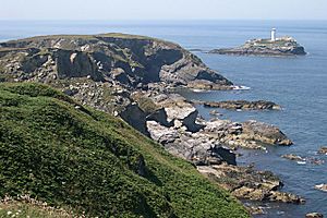
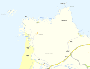
The western side of Godrevy Head has rocky areas to the north and a wide, sandy beach to the south. This beach is a favorite for surfers! At the very tip of the northwest corner is Godrevy Point. At the northeast corner, you'll find Navax Point, which means head of the autumn dwelling in Cornish. The cliffs between these two points are about 67 meters (220 feet) high.
On the northern side of the headland, there are two coves called Mutton Cove and Kynance Cove. Kynance Cove means cove of the autumn dwelling. Beyond these, you might see the Nathaga Rocks, which means milky ones. On the eastern side of the headland are Castle Giver Cove (meaning cove of the goat's castle) and Fishing Cove.
South of Navax Point is an area of heathland called The Knavocks. This name also means autumn dwelling in Cornish. The National Trust looks after this area. It has grassy fields and gorse bushes, with many footpaths for walking. It's a great place to see butterflies and birds, especially nesting stonechats. To keep the heathland healthy, the National Trust regularly cuts back the gorse and uses ponies to graze the land.
Beyond Fishing Cove, the coast turns east towards Hell's Mouth. The land here rises to about 88 meters (290 feet), which is the highest point on this part of the clifftop.
Amazing Animals of Godrevy
The cliffs, rocks, and coast around Godrevy Head are a fantastic home for many seabirds. You can spot birds like cormorants, fulmars, guillemots, razorbills, and several types of gulls. There's also a large group of grey seals that live here all year round. Sometimes, if you're lucky, you might even see bottlenose dolphins swimming in the water!
Godrevy Island and The Stones
Godrevy Island is a small island located about 275 meters (300 yards) off Godrevy Point. This island is not lived on by people, but it's where the Godrevy Lighthouse stands. The lighthouse is managed by Trinity House. The island is about 4.8 hectares (12 acres) in size and is home to seagulls, oystercatchers, and pipits. In spring, you'll see beautiful primroses and sea thrift flowers. To protect the wildlife, you can only land on the island if you have permission from Trinity House.
The Dangerous Stones
Out in the sea, beyond Godrevy Island, there's a hidden reef called The Stones. This underwater reef stretches for about 1.6 kilometers (1 mile) to the northwest. It's been the cause of many shipwrecks over the years. One very sad event was the sinking of the SS Nile in 1854, where everyone on board was lost. After this disaster, people pushed for a lighthouse to be built on Godrevy Island. The lighthouse was finished in 1859 and became fully automatic in 1939, meaning it no longer needed people to operate it.
The Rocks of Godrevy
The rocks at Godrevy are made of mudstone that formed a very long time ago, during the Devonian period. These rocks were laid down in a deep sea basin. On top of these older rocks are layers from more recent ice ages. Godrevy is an important place for studying the Pleistocene epoch, which was a time of many ice ages, from about 2.5 million to 11,700 years ago.
Religion
The Godrevy team ministry is part of the Church of England. It includes five churches in the St Ives area.
 | Isaac Myers |
 | D. Hamilton Jackson |
 | A. Philip Randolph |


