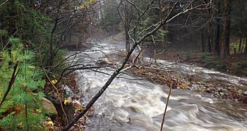
Gosford River facts for kids
Quick facts for kids Gosford River |
|
|---|---|
 |
|
| Country | Canada |
| Province | Quebec |
| Region | Capitale-Nationale, Mauricie |
| Regional County Municipality | Portneuf Regional County Municipality |
| Municipalities | Saint-Raymond |
| Physical characteristics | |
| Main source | Gosford Lake Saint-Raymond, MRC Portneuf Regional County Municipality 291 m (955 ft) 46°56′30″N 71°45′55″W / 46.94167°N 71.76527°W |
| River mouth | Lac Sept Îles Saint-Raymond 209 m (686 ft) 46°44′44″N 71°49′44″W / 46.74556°N 71.82889°W |
| Length | 6.3 km (3.9 mi) |
The Gosford River is a small river in Quebec, Canada. It flows into Sept Îles Lake, which is the start of the Portneuf River. The river is located in the Portneuf Regional County Municipality, within the Capitale-Nationale region.
The Gosford River flows entirely through a forest area. Because of this, forestry (the business of growing and cutting down trees) is the main economic activity in this small valley. Roads like Chemin du rang Notre-Dame and Chemin du rang Gosford help people get around the valley.
The river usually freezes over from early December to late March. However, it's safest to walk or play on the ice from late December to early March. The amount of water in the river changes with the seasons and how much rain or snow falls. A big increase in water, called a spring flood, usually happens in March or April.
Where the Gosford River Starts and Ends
The Gosford River begins in a forest near the rang Gosford Road in Saint-Raymond. The exact spot where it starts is:
- About 1.7 kilometres (1.1 mi) east of a bend in the Sainte-Anne River.
- About 1.4 kilometres (0.87 mi) northwest of a mountain peak that is 432 metres (1,417 ft) high, where a communication tower stands.
- About 10.9 kilometres (6.8 mi) north of the center of Saint-Raymond village.
- About 3.8 kilometres (2.4 mi) north of where the Gosford River flows into another body of water.
From its source, the Gosford River flows south for about 6.3 kilometres (3.9 mi). It flows in a fairly straight line and drops about 82 metres (269 ft) in height along its path.
The Gosford River ends by flowing into a bay on the west side of Sept Îles Lake. From this point, the water travels about 2.8 kilometres (1.7 mi) southeast across Sept Îles Lake. After that, the water flows for about 42 kilometres (26 mi) down the Portneuf River, winding its way southwest towards the north shore of the Saint Lawrence River.
How the Gosford River Got Its Name
The name "Gosford River" comes from the name of the area, or canton, it flows through. This name honors Archibald Acheson, who was the 2nd Earl of Gosford (1776-1849).
Lord Gosford was born in Ireland and had Scottish family roots. He served as the governor-in-chief of British North America from 1835 to 1838. This was a very busy and sometimes difficult time in Canadian history. He came to Canada as a special Royal Commissioner, meaning he was sent by the King or Queen to investigate important issues. His job was to look into the political problems that were causing trouble in Lower Canada (which is now part of Quebec).
Lord Gosford wrote a report about these problems. However, his report did not make the French Canadians happy. Even though he tried to be fair, he asked to be called back home and was replaced by John Colborne. Later, in 1840, Lord Gosford spoke up in the British Parliament in London to defend the French Canadians. He was against a plan to unite Upper and Lower Canada that would have given them the same number of seats in the new government assembly, which he felt was unfair to Lower Canada.
The official name "Rivière Gosford" was formally recognized on August 17, 1978, by the Commission de toponymie du Québec, which is like a government office that names places in Quebec.
 | Stephanie Wilson |
 | Charles Bolden |
 | Ronald McNair |
 | Frederick D. Gregory |

