Sainte-Anne River (Les Chenaux) facts for kids
Quick facts for kids Rivière Sainte-Anne |
|
|---|---|

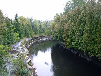
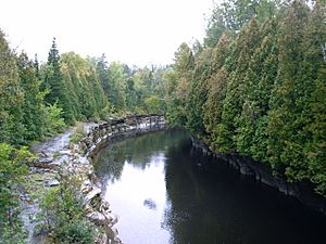
The gorges of the Sainte-Anne river in Saint-Alban.
|
|
| Country | Canada |
| Province | Quebec |
| Region | Capitale-Nationale, Mauricie |
| Regional County Municipality | La Jacques-Cartier Regional County Municipality, Portneuf Regional County Municipality, Les Chenaux Regional County Municipality |
| Municipalities | Lac-Croche, Stoneham-et-Tewkesbury, Saint-Gabriel-de-Valcartier, Saint-Raymond, Saint-Léonard-de-Portneuf, Sainte-Christine-d'Auvergne, Saint-Gilbert, Saint-Alban, Saint-Casimir, Sainte-Anne-de-la-Pérade |
| Physical characteristics | |
| Main source | Lac Sainte-Anne Lac-Croche in Laurentides Wildlife Reserve 662 m (2,172 ft) 47°17′06″N 71°39′36″W / 47.285°N 71.66°W |
| River mouth | Estuary of Saint Lawrence Saint-Anne-de-la-Pérade 4 m (13 ft) 46°33′13″N 72°12′22″W / 46.55361°N 72.20611°W |
| Length | 123 km (76 mi) |
| Basin features | |
| Tributaries |
|
The Sainte-Anne River is a river in Quebec, Canada. It flows into the northern side of the big Saint Lawrence River at a place called Sainte-Anne-de-la-Pérade. This river runs through different areas of Quebec, including:
- Capitale-Nationale region: This includes towns like Stoneham-et-Tewkesbury and Saint-Gabriel-de-Valcartier.
- Portneuf Regional County Municipality: Here you'll find towns such as Saint-Raymond, Saint-Léonard-de-Portneuf, Sainte-Christine-d'Auvergne, Saint-Gilbert, Saint-Alban, and Saint-Casimir.
- Mauricie region: Specifically, the Les Chenaux Regional County Municipality with the town of Sainte-Anne-de-la-Pérade.
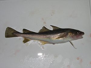
The Sainte-Anne River is famous for its ice fishing in winter. People mainly catch a fish called Tomcod (or poulamon in French). From late December to mid-February, a small village of fishing huts pops up on the frozen river near Ste-Anne-de-la-Pérade.
Sometimes, the river can cause flooding, especially in St-Raymond and occasionally in St-Casimir. Besides the towns, the main ways people make a living around the river are through forestry (cutting down trees), tourism (people visiting for fun), and farming.
The river's surface usually freezes from early December to late March. However, it's safest to walk or drive on the ice from late December to early March. The water level changes with the seasons and how much it rains or snows. The biggest flood usually happens in March or April when the snow melts.
Contents
River's Name: What's in a Name?
No one knows for sure how the Sainte-Anne River got its name. In 1609, Samuel de Champlain called it the Sainte-Marie River, but he didn't say why. Later, in 1641, a map by Jean Bourdon showed it as the Sainte-Anne River, and that name stuck. The Hurons, an Indigenous group, called it "Telahiar."
The name "Rivière Sainte-Anne" was officially recognized on December 5, 1968, by the Commission de toponymie du Québec, which is like the official naming board for places in Quebec.
River's Journey: Where It Flows
River's Start and Path
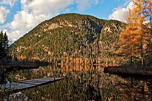
The Sainte-Anne River begins high up in the Laurentides, about 662 metres (2,172 ft) (2,172 ft) above sea level. It starts at the mouth of Lac Sainte-Anne in the Laurentides Wildlife Reserve. This lake is about 4.8 kilometres (3.0 mi) (3 mi) long.
From its source, the Sainte-Anne River flows for about 123 kilometres (76 mi) (76 mi), dropping 651 metres (2,136 ft) (2,136 ft) in height. It travels mainly southwest, passing through several towns and natural areas.
Along its journey, the river goes through:
- Upper Course: It starts by flowing southeast, passing through smaller lakes like Gabriella and Georgiana. It then turns east and south, winding through deep valleys and collecting water from smaller streams and lakes.
- Middle Course: After joining with the Chézine River, it continues south. It passes by the Tourilli River and the Talayarde River, and then flows through the village of Saint-Raymond. Here, it meets the Bras du Nord.
- Lower Course: Further downstream, it passes through the village of Sainte-Christine-d'Auvergne and then the Jacquot River joins it. It flows past Saint-Alban and Saint-Casimir, where it meets the Noire River and the Niagarette River.
- End of the Journey: Finally, the Sainte-Anne River reaches Sainte-Anne-de-la-Pérade and empties into the mighty Saint Lawrence River.
River's Water and Tributaries
The area that drains water into the Sainte-Anne River, called its watershed, covers about 2,694 square kilometres (1,040 sq mi) (1,040 sq mi). On average, about 78 cubic meters (2,755 cubic feet) of water flow out of the river every second at its mouth.
Many smaller rivers and streams flow into the Sainte-Anne River. Some of the main ones are the Tourilli River, the Chézine River, the Talayarde River, the Bras du Nord, the Jacquot River, the Noire River, the Niagarette River, and the Charest River. The watershed also has 828 lakes, with some important ones being Montauban, Long, Blanche, Carillon, and Clair.
River's Rocks and Land
The land under the Sainte-Anne River changes as it flows. Upstream of Saint-Alban, the ground is part of the Laurentian Mountains. Here, the rocks are very old and hard, like gneiss and granite, which are tough against erosion.
Downstream from Saint-Alban, the river enters the St. Lawrence Lowlands. In this area, the rocks are softer, mostly limestone and shale. The whole area is covered by layers of sand, gravel, and clay left behind by ancient seas and glaciers.
People Living by the River
In 2001, about 16,000 people lived in the Sainte-Anne River basin. The town of Saint-Raymond alone has about half of these residents. Other towns located along the river include Sainte-Christine-d'Auvergne, Saint-Alban, Saint-Casimir, and Sainte-Anne-de-la-Pérade.
Nature Around the River
Much of the land around the Sainte-Anne River is covered by forests, making up 80% of the watershed. These forests are a mix of different tree types, including mixed forests, coniferous trees (like pines and spruces), and broadleaved trees (like maples and birches).
The river and its smaller streams are home to 33 different kinds of fish. If you like sport fishing, you might find brook trout, walleye, and smallmouth bass here.
The Sainte-Anne River is also a very important place for Atlantic tomcod to lay their eggs. Between December and February, hundreds of millions of these fish come to the river to spawn. About two million of them are caught by fishers each year. It's thought that a big landslide in 1894 at Saint-Alban created the perfect sandy and gravelly riverbed for these fish to reproduce.
River's Past: A Look Back
The St. Lawrence Iroquoians, an Indigenous group, knew about the Sainte-Anne River a long time ago, even around the year 1000. They were already practicing ice fishing there.
The large population of Atlantic tomcod in the river was "rediscovered" in 1938. After that, ice fishing became very popular, and a village of up to 1,200 fishing huts would appear on the ice. However, too much fishing by both commercial groups and sport fishers caused the tomcod population to drop. To help the fish recover, commercial fishing was stopped in 1992, which allowed the tomcod numbers to grow back.
River's Structures: Dams
There are five dams on the Sainte-Anne River. Three of these dams are used to create electricity. These are the power stations at Saint-Alban, Chutes-à-Gorry, and Glenford.
 | DeHart Hubbard |
 | Wilma Rudolph |
 | Jesse Owens |
 | Jackie Joyner-Kersee |
 | Major Taylor |


