Gowen County facts for kids
Quick facts for kids GowenNew South Wales |
|||||||||||||||
|---|---|---|---|---|---|---|---|---|---|---|---|---|---|---|---|

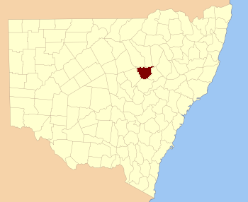
Location in New South Wales
|
|||||||||||||||
|
|||||||||||||||
Gowen County is a special kind of area in New South Wales, Australia. Think of it like an old way of dividing up land, mostly used for keeping records about who owns what. It's one of 141 such areas in New South Wales.
This county is found east of the Castlereagh River. It stretches from a town called Gilgandra in the west, all the way to Coonabarabran in the north-east. The main road, the Newell Highway, also runs through parts of Gowen County.
What is a Cadastral Division?
A cadastral division is a way of splitting up land into smaller parts. These divisions help governments keep track of land ownership and boundaries. They are like invisible lines on a map that help people understand where one piece of land ends and another begins.
Where Did the Name Gowen Come From?
The exact reason why this county was named Gowen is not known. Sometimes, places are named after important people, local features, or even Aboriginal words, but for Gowen County, the origin of its name remains a mystery.
Smaller Areas Inside Gowen County
Counties like Gowen are made up of even smaller areas called parishes. These parishes are like tiny neighborhoods or districts within the larger county. Each parish has its own name and helps to further divide the land for record-keeping. Gowen County contains many different parishes, each with its own unique location.

