
Gracias facts for kids
Quick facts for kids
Gracias
Ciudad de los confines
|
||
|---|---|---|
|
Municipality
|
||
.jpg)
La Merced church from the XVII century.
|
||
|
||

Gracias
Location in Honduras
|
||
| Country | Honduras | |
| Department | Lempira | |
| Founded | 1536 | |
| Area | ||
| • Total | 449 km2 (173 sq mi) | |
| Elevation | 800 m (2,600 ft) | |
| Population
(2023 projection)
|
||
| • Total | 61,421 | |
| • Density | 136.80/km2 (354.3/sq mi) | |
| Climate | Aw | |

Gracias (pronounced GRAH-see-ahs) is a town and municipality in Honduras. It was founded in 1536 and is the capital of the Lempira Department.
The municipality of Gracias has about 61,421 people. The town itself has around 18,550 residents (as of 2023). It is located in the mountains of western Honduras.
Contents
What Does "Gracias" Mean?
The word gracias means "thanks" in Spanish. The story goes that when Spanish explorers first arrived, they were very tired. They had traveled through a lot of mountains. When they reached a flat area, they said, "Gracias a Dios hemos llegado a tierra plana." This means "Thank God we have arrived at flat land."
A Look Back: History of Gracias
How Gracias Was Founded
The city was started in October 1536. It was first named "Gracias a Dios." Gonzalo de Alvarado y Chávez, a cousin of Pedro de Alvarado, founded it. It was built near the Higuito River. For some years, Gracias was a very important city for the Spanish. But later, other cities like Antigua Guatemala became more important.
On January 14, 1539, Gracias a Dios officially became a Municipality.
The Royal Court of Los Confines
In 1544, Gracias became the home of the Royal Court of the Confines. This court was very important. It was in charge of making sure Spanish laws were followed. It also handled land claims and taxes. The court also made sure justice was served.
However, in 1549, the court moved to Santiago de Guatemala. Some people think this was a bad decision. Gracias was in the middle of Central America. This made it a better central spot for the court.
In 1863, General José María Medina became the president of Honduras in Gracias. He was on vacation nearby at the time. In 1949, the city got its first public drinking water service.
Times of Conflict

Gracias has seen some battles. During the civil war of 1919, a group called the "Western Revolutionary Army" attacked the city. This happened on August 11. After a tough fight, they took control of Gracias.
In another civil war in 1924, rebel forces also took over Gracias. This happened on February 7.
Later, in 1959, there was a small rebellion. Some officers took over Fort San Cristóbal in Gracias. But after a short fight, the rebellion ended.
Gracias Today

Today, Gracias is a popular place for tourists in Honduras. Many historic buildings, like the Iglesia de la Merced, have been restored. These buildings are from the colonial period.
The city has grown a lot. In 2018, about 54,404 people lived in the municipality. Most people have a basic education. They often work in farming, raising animals, or fishing. Many homes still cook with firewood.
Gracias has many modern services. You can find banks, restaurants, and markets. There is a hospital, schools, and university centers. The city also has radio stations and TV channels. Tourism has helped the city's economy grow. There is even a small airport runway, opened in 2013.
Who Lives in Gracias?
In 2013, the population of Gracias was 47,622 people.
- About 71% were Mestizo (people with mixed European and Indigenous heritage).
- Around 27% were Indigenous, mostly Lenca people.
- About 1.4% were White.
- Less than 1% were Black or Afro-Honduran.
Exploring the Geography of Gracias
Gracias is located in a mountainous area. The town square is about 800 meters (2,625 feet) above sea level. The highest point is Montaña Celaque, which is 2,870 meters (9,416 feet) high. Celaque is also known as Cerro Las Minas.
The weather in Gracias changes with how high up you are. Lower areas have a wet and dry season. Montaña Celaque is the tallest mountain in Honduras. It also has the largest cloud forest. This forest is protected as part of Celaque Mountain National Park.
Getting Around Gracias
Gracias is a central point for transportation in its region. A paved highway connects the town to Santa Rosa de Copan in the north. Another paved highway to La Esperanza has been under construction for several years.
How Gracias Makes Money

Farming is important in Gracias. Farmers grow crops for themselves and to sell. The types of crops depend on the elevation. Corn and beans are grown in lower areas. Fruits and vegetables are grown higher up in the mountains.
Tourism is also a big part of the economy. People visit Gracias for its history and nature. They come to see the old colonial churches, Celaque Mountain, and the relaxing hot springs.
Images for kids
-
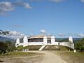
Fortress of Gracias Lempira.
-
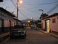
A street of Gracias.
-
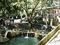
The hot springs of Gracias
See also
 In Spanish: Gracias (Lempira) para niños
