Grape Creek (Colorado) facts for kids
Quick facts for kids Grape Creek |
|
|---|---|

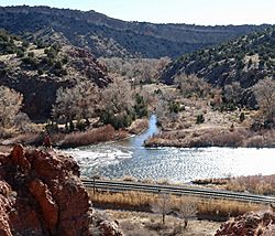
The mouth of Grape Creek, at its confluence with the Arkansas River near Cañon City, Colorado
|
|
| Physical characteristics | |
| Main source | Custer County, Colorado 37°54′31″N 105°28′49″W / 37.90861°N 105.48028°W |
| River mouth | Cañon City, Colorado 5,374 feet (1,638 meters) 38°25′51″N 105°16′07″W / 38.43083°N 105.26861°W |
| Basin features | |
| Progression | Arkansas River—Mississippi River |
Grape Creek is a cool river in Colorado. It flows through Custer and Fremont counties in the southern part of Central Colorado. This creek helps drain a big area called the Wet Mountain Valley. This valley is nestled between two mountain ranges: the Sangre de Cristo Mountains and the Wet Mountains.
Contents
Where Grape Creek Starts and Flows
Grape Creek begins high up in the Sangre de Cristo Mountains. It starts near a place called Blueberry Mountain. From there, the creek tumbles down the eastern side of these mountains. It then reaches the Wet Mountain Valley.
The creek flows north through the valley. It passes near the town of Westcliffe. North of Westcliffe, it goes under Highway 69. Then, it flows northeast into a lake called DeWeese Reservoir.
After leaving the reservoir, Grape Creek continues flowing north. It carves its way through a rocky and wild canyon. Finally, it empties into the Arkansas River. This meeting point is just west of Cañon City.
Special Places Along Grape Creek
Grape Creek flows through several important public lands. These areas are managed to protect nature and offer fun activities.
Bureau of Land Management Area
After leaving DeWeese Reservoir, the creek enters a canyon. This canyon is owned by the Bureau of Land Management (BLM). The BLM is a U.S. government agency. It manages public lands. They have set aside about 16,600 acres (67,000,000 square meters) of this canyon. It is called an "area of critical environmental concern." This means it is a very special place. It needs extra protection for its plants, animals, or historical sites.
San Isabel National Forest
The creek also flows through a small part of the San Isabel National Forest. National Forests are large areas of land. They are managed for many uses. These include recreation, wildlife, and timber.
Colorado State Trust Land
Next, Grape Creek passes through two pieces of land. These lands cover about 1,280 acres (5,200,000 square meters). They are owned by the State of Colorado. Colorado Parks and Wildlife manages these lands. They are called State Trust Lands. These lands offer places for hunting, fishing, and watching wildlife.
Temple Canyon Park
Finally, near the end of the creek's journey, it flows through Temple Canyon Park. This park is about 600 acres (2,400,000 square meters) in size. The city of Cañon City owns and manages it. The park is a popular spot for visitors. It is located just before Grape Creek joins the Arkansas River.
 | Anna J. Cooper |
 | Mary McLeod Bethune |
 | Lillie Mae Bradford |

