
Cañon City, Colorado facts for kids
Quick facts for kids
Cañon City, Colorado
|
||
|---|---|---|

Downtown Cañon City, 2010
|
||
|
||
| Nicknames:
Climate Capital of Colorado
|
||
| Motto(s):
Gateway to the Authentic West
|
||

Location of the City of Cañon City in Fremont County, Colorado.
|
||

Cañon City, Colorado
Location in the United States
|
||
| Country | ||
| State | ||
| County | Fremont County | |
| Settled | 1860 | |
| Incorporated | April 3, 1872 | |
| Government | ||
| • Type | Home rule municipality | |
| Area | ||
| • Total | 12.404 sq mi (32.127 km2) | |
| • Land | 12.392 sq mi (32.095 km2) | |
| • Water | 0.012 sq mi (0.032 km2) | |
| Elevation | 5,312 ft (1,619 m) | |
| Population
(2020)
|
||
| • Total | 17,141 | |
| • Density | 1,383/sq mi (534/km2) | |
| • Metro | 48,939 | |
| • CSA | 217,101 | |
| • Front Range | 5,055,344 | |
| Time zone | UTC−07:00 (MST) | |
| • Summer (DST) | UTC−06:00 (MDT) | |
| ZIP codes |
81212, 81215 (PO Box)
|
|
| Area code(s) | 719 | |
| FIPS code | 08-11810 | |
| GNIS ID | 2409976 | |
| Major Routes | ||

Cañon City (pronounced KAN-yən) is a city in Colorado, United States. It is the main city in Fremont County. In 2020, about 17,141 people lived there.
Cañon City is part of the Front Range Urban Corridor. It sits along the Arkansas River. The city is a popular spot for tourists. People enjoy sightseeing, whitewater rafting, and rock climbing. It is famous for its many parks, fossil finds, and the Royal Gorge Bridge. The city also has lots of natural hiking trails.
In 1994, the official name of the city was changed. A special mark called a tilde (Ñ) was added to "Canon." This made it "Cañon City." It's one of the few U.S. cities with the Spanish letter Ñ in its name.
Contents
History of Cañon City
Cañon City was first planned on January 17, 1858. This was during the Pike's Peak Gold Rush. However, the land was not used right away. A new group took over the town site in late 1859. They built the first building in February 1860. The town was meant to be a trading hub for mining in South Park. It also served the upper Arkansas River area.
Early Years (1860s to 1900)

In 1862, A. M. Cassaday found oil near Cañon City. He drilled for petroleum about 6 miles north of the city. He hit oil at 50 feet deep. This was the first commercial oil well west of the Mississippi River. Cassaday drilled more wells and made kerosene and fuel oil. He sold these products in Denver.
After gold was found at Cripple Creek in 1891, many metal smelters were built in Cañon City. These factories processed metal ores.
Historic Places in Cañon City
The Cañon City Downtown Historic District is a special area. It was added to the National Register of Historic Places in 1983. This means it's an important historical site.
Geography and Climate
Cañon City is in eastern Fremont County. It is mostly on the north side of the Arkansas River. The city is just east of where the river leaves the Royal Gorge. To the south is the community of Lincoln Park.
Via U.S. Route 50, Pueblo is about 39 miles to the east. Colorado Springs is about 45 miles to the northeast. The city covers about 32 square kilometers (12.4 square miles).
Cañon City's Climate
Cañon City is known as "the Climate Capital of Colorado." This is because of its unique location. The city is protected from harsh weather. Its elevation is about 5,300 feet.
The average high temperature in January is about 49.4°F. In July, the average low temperature at night is about 59°F. Cañon City has a semi-arid climate. This means it is generally dry.
| Climate data for Cañon City, 1991–2020 normals, extremes 1893–present | |||||||||||||
|---|---|---|---|---|---|---|---|---|---|---|---|---|---|
| Month | Jan | Feb | Mar | Apr | May | Jun | Jul | Aug | Sep | Oct | Nov | Dec | Year |
| Record high °F (°C) | 80 (27) |
82 (28) |
84 (29) |
90 (32) |
98 (37) |
104 (40) |
107 (42) |
102 (39) |
100 (38) |
95 (35) |
83 (28) |
82 (28) |
107 (42) |
| Mean maximum °F (°C) | 68.1 (20.1) |
69.0 (20.6) |
76.5 (24.7) |
82.1 (27.8) |
89.0 (31.7) |
96.7 (35.9) |
97.8 (36.6) |
95.7 (35.4) |
92.1 (33.4) |
84.9 (29.4) |
75.6 (24.2) |
68.2 (20.1) |
98.8 (37.1) |
| Mean daily maximum °F (°C) | 49.4 (9.7) |
50.4 (10.2) |
58.5 (14.7) |
64.3 (17.9) |
73.3 (22.9) |
84.6 (29.2) |
89.2 (31.8) |
86.7 (30.4) |
80.1 (26.7) |
68.6 (20.3) |
57.2 (14.0) |
49.0 (9.4) |
67.6 (19.8) |
| Daily mean °F (°C) | 33.9 (1.1) |
35.0 (1.7) |
42.3 (5.7) |
48.8 (9.3) |
58.2 (14.6) |
68.4 (20.2) |
73.9 (23.3) |
72.0 (22.2) |
64.2 (17.9) |
52.4 (11.3) |
41.8 (5.4) |
33.8 (1.0) |
52.1 (11.2) |
| Mean daily minimum °F (°C) | 18.4 (−7.6) |
19.7 (−6.8) |
26.1 (−3.3) |
33.2 (0.7) |
43.0 (6.1) |
52.2 (11.2) |
58.7 (14.8) |
57.2 (14.0) |
48.4 (9.1) |
36.1 (2.3) |
26.3 (−3.2) |
18.7 (−7.4) |
36.5 (2.5) |
| Mean minimum °F (°C) | −1.5 (−18.6) |
2.2 (−16.6) |
11.3 (−11.5) |
20.2 (−6.6) |
30.8 (−0.7) |
42.9 (6.1) |
51.9 (11.1) |
50.0 (10.0) |
36.1 (2.3) |
21.2 (−6.0) |
9.0 (−12.8) |
−1.6 (−18.7) |
−8.5 (−22.5) |
| Record low °F (°C) | −24 (−31) |
−30 (−34) |
−13 (−25) |
5 (−15) |
15 (−9) |
30 (−1) |
35 (2) |
35 (2) |
25 (−4) |
−3 (−19) |
−24 (−31) |
−25 (−32) |
−30 (−34) |
| Average precipitation inches (mm) | 0.55 (14) |
0.57 (14) |
1.04 (26) |
1.76 (45) |
1.56 (40) |
0.85 (22) |
2.25 (57) |
2.06 (52) |
1.20 (30) |
0.87 (22) |
0.55 (14) |
0.46 (12) |
13.72 (348) |
| Average snowfall inches (cm) | 6.7 (17) |
6.2 (16) |
6.0 (15) |
4.1 (10) |
0.5 (1.3) |
0.0 (0.0) |
0.0 (0.0) |
0.0 (0.0) |
0.2 (0.51) |
3.3 (8.4) |
5.1 (13) |
6.2 (16) |
38.3 (97.21) |
| Average precipitation days (≥ 0.01 in) | 3.7 | 4.7 | 5.6 | 6.8 | 8.4 | 7.4 | 11.6 | 12.0 | 6.5 | 5.4 | 4.5 | 4.1 | 80.7 |
| Average snowy days (≥ 0.1 in) | 3.4 | 3.9 | 3.0 | 2.1 | 0.4 | 0.0 | 0.0 | 0.0 | 0.0 | 1.0 | 2.5 | 3.8 | 20.1 |
| Source 1: NOAA | |||||||||||||
| Source 2: National Weather Service | |||||||||||||
Neighborhoods in Cañon City


As Cañon City has grown, it has added nearby communities. New neighborhoods have also been built. Here are some of them:
- Dawson Ranch
- Eagle Heights
- Fireman's Bluff
- Four Mile Ranch
- Gold Cañon
- Meadowbrook
- Orchard Park
- South Cañon (a historic area south of the Arkansas River)
- Sunrise Mesa
- Western Meadows
- Wolf Park
- Five Star Mobile Home park
Parks and Recreation
Cañon City has many parks. Some are owned by the city. Others are managed by the Cañon City Area Recreation and Park District.
City Parks
- Centennial Park (also called "Duck Park")
- Denver & Rio Grande Western Park (also called "Depot Park")
- Greydene Park
- Magdalene Park
- Margaret Park
- Mountain View Park (has the city's skate park)
- Red Canyon Park (a 500-acre park 10 miles north of the city)
- Royal Gorge Park (home to the Royal Gorge Bridge and Park)
- Rudd Park
- Temple Canyon Park
- Veterans Park (known for summer concerts)
Recreation and Park District Facilities
The Cañon City Area Recreation and Park District was started in 1965. It helps meet the community's fun needs. It offers parks, a public swimming pool (R.C. Icabone Pool), a dog park, and an archery range. It also has a ropes course and a community room.
Parks run by the Rec District include:
- John Griffin Park (near the Riverwalk)
- Harrison Park (a former school playground)
- Pathfinder Regional Park (shared with Florence)
- Rouse Park
The city also maintains the Tunnel Drive Trail. This is a four-mile trail that follows an old irrigation path.
The Guy U. Hardy Award for Service to Outdoor Recreation honors people. It recognizes those who help protect and promote outdoor fun. Guy U. Hardy greatly helped outdoor activities in the Royal Gorge area.
Population of Cañon City
| Historical population | |||
|---|---|---|---|
| Census | Pop. | %± | |
| 1870 | 229 | — | |
| 1880 | 1,501 | 555.5% | |
| 1890 | 2,825 | 88.2% | |
| 1900 | 3,775 | 33.6% | |
| 1910 | 5,162 | 36.7% | |
| 1920 | 4,551 | −11.8% | |
| 1930 | 5,938 | 30.5% | |
| 1940 | 6,690 | 12.7% | |
| 1950 | 6,345 | −5.2% | |
| 1960 | 8,973 | 41.4% | |
| 1970 | 9,206 | 2.6% | |
| 1980 | 13,037 | 41.6% | |
| 1990 | 12,687 | −2.7% | |
| 2000 | 15,431 | 21.6% | |
| 2010 | 16,400 | 6.3% | |
| 2020 | 17,141 | 4.5% | |
| U.S. Decennial Census | |||
In 2020, there were 17,141 people living in Cañon City. The city had about 1,312 people per square mile. Most residents (95.4%) were White. About 10.2% of the population were Hispanic or Latino.
There were 7,448 households. About 22.6% of these households had children under 18. The average household size was 2.05 people.
About 22.6% of the population was under 18 years old. About 24.6% were 65 years or older. Women made up 52% of the population.
Local Government and Services
Cañon City has its own police department. It also has a sheriff's office and a municipal court. The city is home to the courts for Fremont County. It also hosts the 11th Judicial District of Colorado.
Economy and Jobs
The land along the Arkansas River is good for farming and ranching. But Cañon City's economy also relies on other things. These include tourism, education, and manufacturing. The city also has many state and federal prisons.
Main Employers
Cañon City's main jobs come from the Colorado Department of Corrections and the federal prison system. Tourism is also very important. Tourist spots include the Royal Gorge Route Railroad, Royal Gorge Bridge and Park, and Red Canyon Park. Local shops and the St. Thomas More Hospital are also big employers.
Prisons in the Area
Prisons are a big part of the economy in Cañon City and Fremont County. The Museum of Colorado Prisons helps preserve the history of the state's prison system. The Colorado Territorial Correctional Facility is in Cañon City. Other state prisons are in nearby areas of Fremont County.
Tourism in Cañon City
From the historic downtown to the Royal Gorge Bridge, there are many places to visit. The Cañon City Downtown Historic District is a popular spot.
Media and News
Cañon City has a daily newspaper called the Cañon City Daily Record. It also has an FM radio station, Star Country 104.5 FM. There is also a long-running AM radio station, KRLN NewsRadio 1400 AM.
Getting Around Cañon City
You can get around Cañon City by cab or shuttle bus. There's also a fun downtown wagon ride. Jeep tours and Segway tours are available. These tours let you explore parks like Red Canyon Park or scenic spots like Skyline Drive.
The Fremont County airport (1V6) is 6 miles east of the city. It does not have regular passenger flights. The Colorado Springs Airport is about an hour away. It has daily flights from major airlines.
Major Roads and Highways
The area has one state highway and one U.S. highway. There are also city and county roads.
State and National Highways
- U.S. Highway 50: This road is called Royal Gorge Boulevard in downtown Cañon.
- State Highway 115: This road connects Cañon City to nearby Florence and Penrose. It ends in Colorado Springs.
City and County Roads
- 4th Street: Connects downtown with South Cañon and other areas.
- 5th Street: A north-south road from downtown. It helps traffic from Skyline Drive return to U.S. 50.
- 9th Street: Carries CO 115 for a bit and heads north.
- 15th Street: The main road north to the hospital and some businesses.
- Orchard Avenue
- Raynolds Avenue/Ash Street: Runs from East Cañon to CO 115.
- MacKenzie / Four Mile Lane: Connects from CO 115.
Bus Service
Cañon City is part of Colorado's Bustang network. It is on the Alamosa-Pueblo Outrider bus line.
Scenic Routes
- Skyline Drive: This is a major scenic road. It overlooks Cañon City. It was built by local inmates from the Territorial Prison.
Railroads
The Union Pacific Railroad stopped using the Tennessee Pass line in 1997. In 1998, Rock and Rail LLC started operating on parts of this track. They run trains between Cañon City and Parkdale. They also operate between Pueblo and Cañon City. The tourist train, Cañon City and Royal Gorge Railroad, also uses these tracks.
Education in Cañon City
Cañon City's schools are managed by the Cañon City School District Fremont RE-1. The district has four elementary schools. It also has one charter school and one school that serves both elementary and middle school students. There is one middle school and one high school, Cañon City High School.
For higher education, Pueblo Community College has a campus in Cañon City. It is located on the west side of the city along U.S. Highway 50.
Places to Visit
Listed on the National Register of Historic Places
- Cañon City Downtown Historic District
- Cañon City Municipal Building (also known as the Royal Gorge Regional Museum and History Center)
- Cañon City Post Office and Federal Building
- Cañon City State Armory
Famous People from Cañon City
- Robert Wesley Amick: An artist.
- Don Bendell: A writer.
- Jack Christiansen: An NFL Hall-of-Famer for the Detroit Lions.
- Donald S. Fredrickson: A medical researcher. He was born in Cañon City.
- Skip Konte: A musician.
- Vice Admiral Emory S. Land: A U.S. Navy officer, born in Cañon City.
- Bird Millman: A circus aerialist, born in Cañon City.
- James Hamilton Peabody: A former governor of Colorado.
Sister Cities
Cañon City has special connections with cities in other countries. These are called sister cities:
 Chalchicomula de Sesma, Mexico
 Kahoku, Japan
 Valday, Russia
Images for kids
-
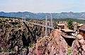
The Royal Gorge Bridge in 1987.
-
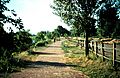
The Arkansas Riverwalk is part of John Griffin Regional Park.
See also
 In Spanish: Cañon City para niños
