Greystone Bridge facts for kids
Quick facts for kids Greystone Bridge |
|
|---|---|

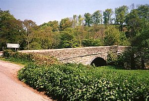
Greystone Bridge in 1995
|
|
| Coordinates | 50°36′00″N 4°18′25″W / 50.599931°N 4.306952°W |
| Carries | B3362 |
| Crosses | River Tamar |
| Locale | Cornwall and Devon border in southwest England |
| Characteristics | |
| Width | 3 metres (9.8 ft) |
| Longest span | 7 metres (23 ft) |
| History | |
| Construction end | 1439 |
| Statistics | |
| Toll | No |
Greystone Bridge is a very old and important bridge in southwest England. It crosses the River Tamar, right on the border between Cornwall and Devon. This bridge was built way back in 1439 and is still used today! It's so special that it's protected as a Grade I listed building. This means it's a historic structure that must be carefully preserved.
Contents
About Greystone Bridge
Greystone Bridge is located southeast of Launceston, Cornwall. It carries the B3362 road over the River Tamar. The bridge is made of stone, with special cut stones called freestone used for its outer layer.
Bridge Design and Features
The road across the bridge is about 3 meters (10 feet) wide. The bridge has special pointed parts called cutwaters that stick out from its base. These help to break the flow of the river water. They reach up to 8.2 meters (27 feet) from the riverbed. There is also a safe path for people to walk on.
The bridge has four main arches that are shaped like segments of a circle. It also has two extra arches on each bank. These are called floodwater arches and they help the bridge handle extra water during floods. Each of these arches measures about 4.3 meters (14 feet) wide.
History of Greystone Bridge
Greystone Bridge was built a very long time ago, in 1439. Its construction was supported by a special permission called an indulgence. This was granted by Bishop Lacy of Exeter on December 27, 1439.
Who Built the Bridge?
Experts believe that Greystone Bridge and another nearby bridge, the Horsebridge, were built by the same person. Both bridges cross the River Tamar. It is thought that an important religious leader, an Abbot of Tavistock, helped to fund the building of Greystone Bridge.
Repairs and Protection
Because Greystone Bridge is so old, it sometimes needs repairs. Large vehicles often damaged its side walls, called parapets. In November 2007, the bridge was repaired. The entrance on the Cornwall side was also made wider to help traffic. New traffic lights were put in place to make crossing safer.
Today, Greystone Bridge is not just a Grade I listed structure, but also a scheduled ancient monument. This means it's a very important historical site that is protected by law. It helps us remember the history and building skills of people from hundreds of years ago.
 | George Robert Carruthers |
 | Patricia Bath |
 | Jan Ernst Matzeliger |
 | Alexander Miles |

