Grosvenor Canal facts for kids
Quick facts for kids Grosvenor Canal |
|
|---|---|

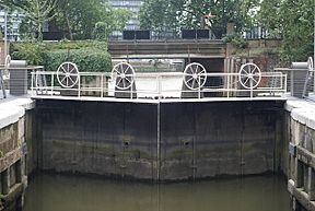
The view from the entrance lock towards the River Thames
|
|
| Specifications | |
| Status | Closed, mostly infilled |
| History | |
| Date of first use | 1824 |
| Date completed | 1825 |
| Date closed | 1858, 1925, 1990s |
| Geography | |
| Connects to | River Thames |
The Grosvenor Canal was once a busy waterway in the Pimlico area of London. It opened in 1824. Over time, it became shorter and shorter. This happened as railways and buildings were constructed over parts of it.
The canal was used until 1995. It helped barges carry rubbish away from the city. This made it the very last canal in London to be used for business. Today, only a small part of it remains. You can find it near the Grosvenor Waterside development.
Contents
A Canal's Journey: From Creek to Commercial Hub
In the early 1700s, the area near Pimlico had marshy land and a natural creek. A company called the Chelsea Waterworks Company got permission in 1722 to take water from the River Thames. They used this water to supply west London with drinking water. They built a tide mill to pump the water. Later, a steam engine took over the pumping.
The land belonged to Sir Richard Grosvenor, 4th Baronet. The waterworks company leased it from him. In 1823, their lease ended.
Building the Canal
In 1824, the Earl of Grosvenor decided to turn the creek into a proper canal. They built a lock near the Thames and a basin further inland. A basin is like a wide pool where boats can turn around or load goods.
Most of the boats on the canal carried coal. This coal was used to heat homes and power businesses nearby. John Armstrong was the engineer who designed the lock and the basin. The canal officially opened in 1824.
The Chelsea Waterworks continued to use the canal for water. But in 1852, a new law stopped them from taking water from the Thames in that area. They moved their operations further upriver in 1856.
Shortening the Canal
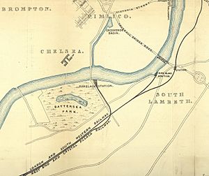
The canal originally ran from the Thames near Chelsea Bridge all the way to Grosvenor Basin. This basin is now the site of Victoria Station. Maps from the 1850s show the basin was very large.
Around 1858, Victoria Station was built. The railway company made an agreement with the Duke of Westminster. This allowed them to build the station over the basin. The station opened in 1860.
As the railways grew, they needed more space. In 1899, another law allowed the canal to be closed above Ebury Bridge. This happened around 1902. The canal became half its original length.
Since 1866, the local council had used the canal to move household rubbish. They were based near the end of the canal at Ebury Bridge. After the canal was shortened, the Duke of Westminster sold the rest of it to Westminster City Council. Moving rubbish became its main job.
Around 1925, the canal was made even shorter. This was to allow the Ebury Bridge housing estate to be built. The lower part of the canal was kept as a dock. This allowed the council to keep loading rubbish onto barges.
In 1928, the canal closed for almost a year for big improvements. At its busiest, 8,000 tons of rubbish were loaded onto barges every week! This rubbish transport continued until 1995. This made the Grosvenor Canal the last canal in London to be used for business.
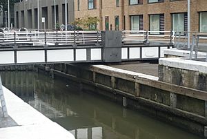
Today, the area is called Grosvenor Waterside. The lock and the basin near the Thames are still there. The lock has three sets of gates. Two face away from the Thames. A third set faces towards the Thames. This helps manage the water when the river level is very high.
The Canal's Path
The Grosvenor Canal starts where it meets the River Thames. It passes under Grosvenor Road, which runs along the river. On the side away from the river is the Lower Basin. This basin is affected by the tides and is often empty when the tide is low.
Just north of the Lower Basin is the lock. Above the lock was a wider area called the Upper Basin. In the past, there were timber yards, saw mills, and iron works along the canal.
A large sewage pumping station was also built nearby by 1875. This was an important part of London's drainage system. It helped pump sewage away from the city.
Further along the canal, towards Ebury Bridge, the railway tracks were very close to the east bank. There were many wharves (places where boats could load and unload goods) along this section. Over time, these wharves disappeared as the railway expanded.
Beyond Ebury Bridge, the canal continued with more wharves. But eventually, these also disappeared under the railway tracks. The canal ended before Eccleston Bridge, as the railway tracks curved to reach Victoria Station.
Points of Interest
| Point | Coordinates (Links to map resources) |
OS Grid Ref | Notes |
|---|---|---|---|
| Site of Grosvenor Basin | 51°29′41″N 0°08′43″W / 51.4946°N 0.1454°W | TQ288789 | Under Victoria Station |
| Site of Eaton Wharf | 51°29′33″N 0°08′49″W / 51.4926°N 0.1470°W | TQ287787 | Under railway sidings |
| Site of Ebury Wharf | 51°29′27″N 0°08′56″W / 51.4908°N 0.1490°W | TQ286784 | now a car park |
| Upper basin | 51°29′15″N 0°08′57″W / 51.4875°N 0.1492°W | TQ286781 | |
| Lower basin | 51°29′10″N 0°08′58″W / 51.4862°N 0.1494°W | TQ285779 |
 | Delilah Pierce |
 | Gordon Parks |
 | Augusta Savage |
 | Charles Ethan Porter |


